Download
1 / 4
70 likes | 311 Views
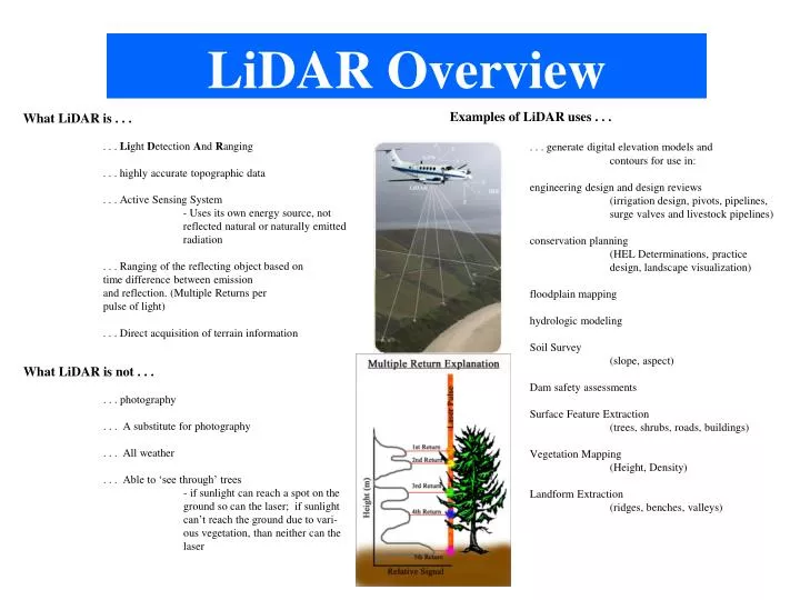
LiDAR Overview. Examples of LiDAR uses . . . . . . generate digital elevation models and contours for use in: engineering design and design reviews (irrigation design, pivots, pipelines, surge valves and livestock pipelines) conservation planning

E N D
LiDAR Overview Examples of LiDAR uses . . . . . . generate digital elevation models and contours for use in: engineering design and design reviews (irrigation design, pivots, pipelines, surge valves and livestock pipelines) conservation planning (HEL Determinations, practice design, landscape visualization) floodplain mapping hydrologic modeling Soil Survey (slope, aspect) Dam safety assessments Surface Feature Extraction (trees, shrubs, roads, buildings) Vegetation Mapping (Height, Density) Landform Extraction (ridges, benches, valleys) What LiDAR is . . . . . . Light Detection And Ranging . . . highly accurate topographic data . . . Active Sensing System - Uses its own energy source, not reflected natural or naturally emitted radiation . . . Ranging of the reflecting object based on time difference between emission and reflection. (Multiple Returns per pulse of light) . . . Direct acquisition of terrain information What LiDAR is not . . . . . . photography . . . A substitute for photography . . . All weather . . . Able to ‘see through’ trees - if sunlight can reach a spot on the ground so can the laser; if sunlight can’t reach the ground due to vari- ous vegetation, than neither can the laser
Future LiDAR collection contact information: Nathan Watermeier GIS Administrative Manager Office of the Chief Information Officer State of Nebraska GIS Council/NITC 402-471-3206 Nathan.Watermeier@nebraska.gov http://nitc.nebraska.gov/gisc http://www.NebraskaMAP.gov