Download
1 / 25
250 likes | 427 Views
Geostationary Operational Environmental Satellites (GOES) Advanced Very High Resolution Radiometer (AVHRR) Systeme por l’Observation de la Terre (SPOT) For Next Class: Read rest of Chapter 7. Multispectral Remote Sensing: Part II.

E N D
Geostationary Operational Environmental Satellites (GOES) Advanced Very High Resolution Radiometer (AVHRR) Systemeporl’Observation de la Terre (SPOT) For Next Class: Read rest of Chapter 7 Multispectral Remote Sensing: Part II
http://www.nasa.gov/home/hqnews/2013/feb/HQ_13-040_LDCM_Launches.htmlhttp://www.nasa.gov/home/hqnews/2013/feb/HQ_13-040_LDCM_Launches.html
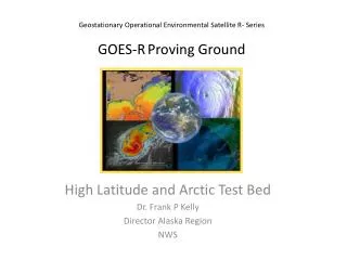
GOES East Coverage GOES East Infrared August 25, 1989 GOES East Visible August 25, 1989 Jensen, 2000
GOES East Infrared GOES East Visible GOES East August 25, 1989 GOES East Water Vapor Jensen, 2000
http://www.oso.noaa.gov/goes/ • http://weather.rap.ucar.edu/satellite/
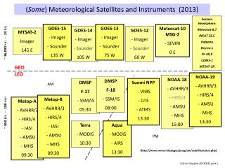
What are the spatial, spectral, radiometric, and temporal resolution of the GOES products?
On board NOAA’s Polar Orbiting Operational Environmental Satellites (POES) Very useful for calculating vegetative indices over large areas and analyzing seasonal growth cycles Such as the NDVI (Normalized Difference Vegetation Index) http://noaasis.noaa.gov/NOAASIS/ml/avhrr.html Advanced Very High Resolution Radiometer (AVHRR) Advanced Very High Resolution Radiometer (AVHRR)
Advanced Very High Resolution Radiometer (AVHRR) Imagery Jensen, 2000
Advanced Very High Resolution Radiometer (AVHRR) Mosaic of the Conterminous United States Jensen, 2000
Global Normalized Difference Vegetation Index (NDVI) Image Produced Using Advanced Very High Resolution Radiometer (AVHRR) Imagery Jensen, 2000
What are the spatial, spectral, radiometric, and temporal resolution of the AVHRR products?
SPOT 1-5 Panchromatic and Multispectral Mode Improved spatial resolution compared with Landsat Off-nadir viewing capabilities are extremely helpful Can point the sensor “off-nadir” to obtain stereoscopic imagery http://www.spot.com/html/SICORP/_401_.php Systeme por l’Observation de la Terre (SPOT) Systeme Por l’Observation de la Terre (SPOT)
Chronological Launch History of the SPOT Satellites Jensen, 2000
SPOT Satellite System Components Courtesy of SPOT Image, Inc. Jensen, 2000
SPOT Off -NADIR View Jensen, 2000
SPOT Off -NADIR Revisit Capabilities Jensen, 2000
SPOT Stereoscopic Viewing Capabilities Jensen, 2000
Comparison of the Detail of 30 x 30 m Landsat TM Band 3 Data and SPOT 10 x 10 m Panchromatic Data of Charleston, SC Courtesy of SPOT Image, Inc. Jensen, 2000
Geographic Coverage of the SPOT HRV and Landsat Thematic Mapper Remote Sensing Systems Jensen, 2000
Portion of the First Global 10-day Synthesis Image Produced Using the SPOT Vegetation Sensor May 11-20, 1998 Courtesy of SPOT Image, Inc. Jensen, 2000
What are the spatial, spectral, radiometric, and temporal resolution of the SPOT products?