Download
1 / 20
200 likes | 420 Views
The Role of Geostationary Environmental Satellites in the WMO Space Programme -------------. Dr Donald E. Hinsman Head WMO Space Programme World Meteorological Organization. Outline. Space-based component GOS WMO Space Programme

E N D
The Role of Geostationary Environmental Satellites in the WMO Space Programme ------------- Dr Donald E. Hinsman Head WMO Space Programme World Meteorological Organization
Outline • Space-based component GOS • WMO Space Programme • Present and potential configurations related to geostationary satellites
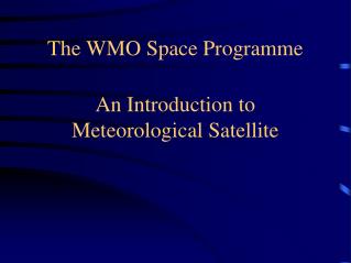
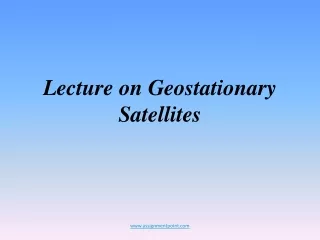
On April 1, 1960 the first U.S. • weather satellite was • launched from • Cape Canaveral, FL Satellites were the genesis On April 1, 1960 the first U.S. weather satellite was launched from Cape Canaveral, FL • SATELLITES AND THE WWW • UN Resolution No. 1721 for “international co-operation in the peaceful uses of outer space” approved 20 December 1961 • Advent of satellites offered substantial opportunities for improvements in meteorological services • Called on WMO to lead a study and report on recommendations of the UN Resolution • Report delivered in June 1962 • “First report on the advancement of atmospheric sciences and their application in the light of developments in outer space” • Birth of World Weather Watch
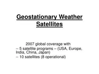
Global System of Geostationary Satellites
WMO space-based component of the Global Observing System (2004) Unparalleled international cooperation has been achieved in satellite activities*
Space-based component of the GOSR&D constellation • Newest members • NASA – Aqua, Terra, NPP, TRMM, QuickScat • JAXA – ADEOS-II, GCOM series • ESA – ERS 1 and 2, ENVISAT • RASA –METEOR 3M N1 (R&D inst), OKEAN series • CNES – Jason-1, SPOT-5
WMO Space Programme • Fourteenth WMO Congress (May 2003): • Recognized critical and fast growing importance of data, products and services provided by WWW’s expanding space-based component of the GOS to WMO Programmes and supported Programmes • Decided to initiate a new major WMO Space Programme as a cross-cutting programme to increase the effectiveness and contributions from satellite systems • CBS lead Technical Commission
WMO Space Programme Objectives • Contribute to the development of WWW’s Global Observing System (GOS), through the full participation of WMO Members, as a composite system comprised of surface and space-based components • Encourage and facilitate the evolution of WWW’s GOS by taking advantage of advances and improvements made possible by WMO Members
WMO Space Programme Objectives • Promote high-quality satellite-related continuing education to keep the knowledge and skill of Members’ operational and scientific staff up-to-date with the latest technological innovations, and to provide the competence and skills needed in related fields, such as communications with users • Review the space-based components of the various observing systems throughout WMO Programmes and WMO supported Programmes,towards the development of an integrated WMO global observing system that would encompass all present WMO observing systems
WMO Space Programme (continued) • 2004-2007 Space Programme activities include • Regional workshops to make WMO Members aware of new capabilities for disaster and mitigation support • Education and training events for R&D satellite data and products for disaster and mitigation support • Workshops to identify selected instruments for transition from R&D to operational
WMO Consultative Meetings on High Level Policy on Satellite Matters Fourteenth WMO Congress (May 2003): • Convinced the dialogue between WMO and environmental satellite communities had matured rapidly • Institutionalized “WMO Consultative Meetings on High-level Policy on Satellite Matters” by resolution to establish formally dialogue with environmental satellite agencies • Chaired by the President of WMO • WMO Bureau members • Heads of space agencies • Maintain a high level overview of the WMO Space Programme
International coordination • CGMS (Coordination Group for Meteorological Satellites) • CEOS (Committee on Earth Observation Satellites) • IGOS (Integrated Global Observing Strategy) Partnership • COPUOS (UNISPACE III) • GEO and its GEOSS (WWW’s space-based GOS, a major GEOSS component)
Vision for the future: A 2020 Perspective • 30 minute warning of very destructive weather events • 1-12 hour severe weather events • 5 day hurricane track prediction to +/-30 km • 10-14 day weather forecast • 12 month regional rain rate including Monsoon forecasts • 15-20 month El Niño prediction • 10 year climate forecasts • WMO Space Programme TD • The Role of Satellites in WMO Programmes in the 2010’s • 2003, (SP-1, Technical Document WMO/TD No. 1177) • Mr Greg Withee, Dr Ghassem Asrar and Dr Tillmann Mohr
Four critical areas (all dealing with resolution) • spatial resolution – picture element size required • spectral coverage and resolution – portion of the continuous electromagnetic spectrum required • temporal resolution – how often • radiometric resolution – signal to noise required, accuracy
Geostationary Satellites • High spatial resolution hyperspectral imaging and atmospheric sounding capability • Routine rapid interval full disk imaging • Routine full disk sounding at a variety of temporal resolutions • Exploration of advanced sensor technology for lightning detection and microwave applications • 60 degree sub-point separation for geostationary satellites
WMO’s role • Establishment of an adequate data dissemination service for the 2025 era • Global approach to product development • International processing centres for the “operational” products
Exciting times for WMO Members • Space-based component of the GOS greatly expanded • Provides valuable satellite data, products and services more so than ever before in the history of the World Weather Watch • WMO established a new WMO Space Programme - provides for both external and internal coordination necessary to maximize the exploitation of the new GOS