Download
1 / 27
270 likes | 350 Views
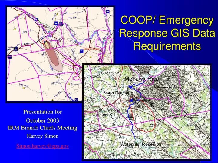
COOP/ Emergency Response GIS Data Requirements. Presentation for October 2003 IRM Branch Chiefs Meeting Harvey Simon Simon.harvey@epa.gov. GIS Work Group Efforts. GIS Work Group met in Dallas in late September and had a group discussion about ER and COOP data needs

E N D
COOP/ Emergency Response GIS Data Requirements Presentation for October 2003IRM Branch Chiefs Meeting Harvey Simon Simon.harvey@epa.gov
GIS Work Group Efforts • GIS Work Group met in Dallas in late September and had a group discussion about ER and COOP data needs • Discussed results of COOP/RRC GIS Readiness Survey • Will summarize results of discussion here, but • Main determination was that there are some pressing data needs that could/should be addressed right away • Decided to make small group of GIS and OSC staff to prepare white paper and marketing plan • White paper not drafted yet, but this presentation is a good opportunity to paint the data needs picture • Created ER/COOP section of Work Group Web site: • http://intranet.epa.gov/gis/emerg_resp-coop/index.html
Background • Survey sent to primary GIS contacts in each of the Regions after last GIS Workgroup meeting • Purpose was to • Get a snap shot of where each Region was in GIS readiness at COOP and RRC issues • Tease out issues that need coordinated follow-up to resolve
COOP/RRC Readiness Survey Results Summary • Staffing and Planning • Some GIS groups (less than half) actively involved in COOP/RRC planning, others banging on the door trying to get in. Staffing varies widely. COOP/RRC staffing/location overlap varies. • Continuing Operations (COOP) (off-site) • Most Regions have some sort of GIS capacity at COOP site • Variety of methods of storing, accessing and backing/mirroring data employed • Regional Response Center • Better involvement and preparedness on RRC support than COOP, but lack of involvement in a number or regions. • Software • Arcview 3.x, ArcGIS and ArcIMS primary tools
General Readiness Lots of work to be done here
Top five data sets identified as needed for emergency response: 1 roads 2 demographics 3 sensitive areas 4 drinking water intakes, general water features 5 schools COOP/RRC Readiness Survey Results Summary • Be careful about surveys, on discussion, consensus seemed to be not quite what everyone expected. Missing DOQs and Scanned Topo maps.
Likely Scenarios: COOP/RRC • Variety of situations that could depend on mapping/GIS support • Emergency Response • Chemical releases, fires and oil spills • Natural disasters • Terrorism • COOP • Weather, power outages lead to short term facility shutdowns • Buildings unavailable as part of a broader disaster (see above) • Except for short term COOP activation all of these require quick basemapping and modeling to help assess the situation and mobilize response.
GIS Needs – Days 0-3: • Basemapping, Quick, simply understood maps of situation (Important data for this – Roads, administrative boundaries, scanned topo maps, digital orthophotos, elevation data, hydrography, critical infrastructure (facilities, schools, water supplies, utilities, etc.) • Quick and relatively (relative to road network) accurate georeferencing of events, activities and resources • Integration with weather data and quick dispersion model outputs needed • Mapping assistance in planning initial monitoring runs • Speed of the essence, seconds critical, dawdling over design can make efforts useless, slow printing also deadly • Quick video display in response centers essential, • Hard copies also vital, quick printing in response centers and out to field units essential
GIS Needs – Days 4-14: • Basemapping and logistical mapping requirements continued, standardized outputs begin to evolve. • Integration of early data, environmental information and models to help long term monitoring development and QA plans • Integrate SCRIBE (or other monitoring database system) with GIS to develop standard data visualizations, situation and pollution reports.
What do we need to support this? • Bare minimum: • National, updated address matched road and transportation data that with matching administrative and census boundaries as web services and as downloadable data • Web service subscriptions for updated scanned quads and digital orthophotos, need option for downloads • These data are available commercially now, should be purchased this year and made available. • In addition to being critical for emergency response have value in most other EPA applications, including locational data improvement
Address Match Roads – OEI Evaluation (GDT vs. TeleAtlas) • Positional accuracy • Currentness of data • Geocoding • Network analysis & routing • Rich street attributes • Enhanced census boundary files • Traffic count data • Ability to download data for disconnected use
Longer term, but vital investments • 1:24 K NHD, Reach Address Database and Watershed Boundary dataset • Critical Infrastructure • Pipelines • Schools, hospitals • Water supplies • Endangered Species (NatureServe data), NOAA environmental scnsitivity maps • DayTime/Night Time Population Estimates (Landscan) • Need to participate collaborative efforts to acquire or build these data sets and fund our share of their development. • Chemical storage facilities • Utilites • Dams, canals
Issues • Some regions are better off than others in these data areas, no consistency across the board • Currency and quality of data they have are issues (e.g. age of DOQs, use of Census roads for address matching, lack of agreement between Census roads and imagery) • Need consistent national datasets as default, use better local data when available
How Do We Move Forward • OEI/OSWER cooperation on data acquisition? • Funding • Coordination • Procurement • Access, delivery internally • IRM Branch Chief advice on how to elevate spatial data acquisition needs as a priority?
Data Management Lessons Learned from Region 2 August 2003 Emergency Response Drill • Requires: • I.T. support and specialized staff to support vital tools • Redundant network and internet access at host facilities • Development of standard map templates and geocoding tools for a range of anticipated emergencies
Data Management Lessons Learned - Continued • (Cont.) • Develop data management SOPs centered around SCRIBE, PDAs, and Laboratory Information Management System (LIMS) • Define redundant information transfer and storage systems (FTP, e-mail, modems)
Data Management Lessons Learned - Continued • EPA and NYSDEC should work to: (cont’d) • Standardize and train critical SSG/EU staff on core tools: • SCRIBE • CATS-JATS, HPAC • WebEOC • External EPA Emergency Response website • ICS • Stand alone street atlases, topo maps & nautical charts • Data compression tools (winzip, Adobe Acrobat, FTP) • Security tools (encryption)
Data Management Lessons Learned - Continued • The development of critical information in electronic format is a critical piece of the response process. This included: • digital images, • GIS themes, • database files, etc. • The movement and interpretation of these work products between response groups is critical to developing response strategies and analysis of the situational picture.
Data Management Lessons Learned – Continued • If you don’t have the infrastructure in place, you waste the human resources. Any investments made in display processing and associated technologies are well worth it.
Data Management Lessons Learned – Detailed Recommendations • Define IT support needs for Edison and Albany Coordination Centers and identify specific staff for supporting vital tools and network access. • Provide for adequate capability for staff from cooperating organization to connect their computers to local network and/or get Internet access. • Develop standard map templates, geocoding tools for range of anticipated emergencies.
Data Management Lessons Learned – Detailed Recommendations • Develop data management SOPs centered around SCRIBE, PDAs and Laboratory Information Information System (LIMS). • Define redundant information transfer and storage systems, i.e. FTP, email, modem. • Standardizing and training of critical SSG/EU staff on core tools: • SCRIBE • CATS-JACE, HPAC • CAMEO • Web EOC • epaosc.net • ICS • Stand alone street atlases • Stand alone topography maps • Nautical charts • Data compression tools (winzip, adobe acrobat, FTP) • Security tools (encryption)
Data Management Lessons Learned – Detailed Recommendations • Identify ER geospatial data needs assessment; fill any critical gaps. • Have follow- up drills to test data management SOPs and ability to produce critical basemaps, plume outputs, resource tracking and other vital information products. • Reasonable time targets to create and distribute information deliverables need to be developed and trained to. • Institutionalize having an EPA representative in the ERCC Situation Unit to help expedite the flow of information to the EPA Region 2 RRC.
Data Management Lessons Learned – Detailed Recommendations • Develop and assign a core of “technical specialists” assigned to assist the OSC in the field. This team should include: • IT/Communications Technician, • SSC, . • This team should liaison with RRC for additional assistance, but main function is to relieve the OSC from having too many issues to address that could quickly overwhelm the OSC. This will also allow the OSC to focus on tactical issues for the response. • Mobilization capabilities will need to be developed and could possibly include: vehicle, satellite capabilities, “Go-Kit”, etc. Further discussion needs to develop medical monitoring, training, and qualification considerations for any personnel assigned to the field • safety officer, • contract support.
Data Management Lessons Learned – Detailed Recommendations • Protocol needs to be established for the handling of sensitive information within the response organization. • Full Region 2 Drill lessons learned presentation and report at: http://www.epaosc.net/ResponseExercise