Download
1 / 2
20 likes | 130 Views
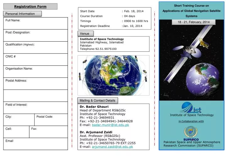
Short Training Course on Applications of Global Navigation Satellite Systems. Registration Form. Start Date : Feb. 18, 2014 Course Duration : 04 days Timings : 0900 to 1600 hrs Registration Deadline :Jan. 10, 2014. Personal Information. 18 - 21, February, 2014. Venue.

E N D
Short Training Course on Applications of Global Navigation Satellite Systems Registration Form Start Date : Feb. 18, 2014 Course Duration : 04 days Timings : 0900 to 1600 hrs Registration Deadline :Jan. 10, 2014 Personal Information 18 - 21, February, 2014 Venue Institute of Space TechnologyIslamabad Highway, Islamabad PakistanTelephone:92.51.9075100 Mailing & Contact Details Dr. Badar Ghauri Head of Department RS&GISc Institute of Space Technology Ph: +92-21-34694931 Fax: +92-21-34694941-34644928 E-mail: badar.munir@ist.edu.pk Dr. Arjumand Zaidi Asst. Professor (RS&GISc) Institute of Space Technology Ph: +92-21-34650765-79 EXT:2255 E-mail: arjumand.zaidi@ist.edu.pk Institute of Space Technology in Collaboration with Pakistan Space and Upper Atmosphere Research Commission (SUPARCO)
OBJECTIVE • Global Positioning System, or in short GPS, is serving positioning and navigation requirements for over two decades. Currently GPS is the GNSS primarily used by both military and civilian users. Employing hand-held devices, these signals can be used to accurately pinpoint user’s location anywhere on the globe, at zero cost. The GNSS signals, now globally available are used to advance applications which were pioneered using GPS. • In Pakistan, use of GPS is growing day by day for applications including fleet tracking and management, machine guidance, Location Based Services (LBS) and most importantly surveying and mapping. Regardless of the GNSS used, various applications could be grouped into following categories: Personal Navigation, Aviation Application, Automotive Application, Marine Application, Space Application, Agriculture, Forestry and Natural Resources Exploration, Geodesy & Precision Surveying, Remote Sensing of Environment etc. • This course is aimed at imparting the participants with knowledge about GPS/DGPS/GNSS, its working principles and modern day applications. More importantly, it covers the practical aspects of the technology from user’s point of view. In addition, it provides information about GPS data collection in the field, and suggests data filtering techniques and ways to avoid data corruption. This course also offers guidance and data to users on selecting right equipment for their use. • The main course contents include: • Global Navigation Satellite Systems: Present and Future • GNSS Navigation: Estimating Position, Velocity and Time • Global Navigation Satellite System including Gallileo, GLONASS, BeiDou and GPS modernization • Real Time Kinematic (RTK) Positioning • GPS Receiver Usage, typically used data formats (NMEA, RINEX etc), online data sources; • A GPS Software Receiver • Indoor and Weak Signal Navigation • Applications of GNSS, including both positioning and non- positioning applications • Disaster management and emergency response system, • Business Possibilities related to GPS/GNSS in Pakistan • The course will cover the concepts of global positioning, location determination, its accessibility to end-users and the various augmentations systems available for service enhancement as well as the future of GNSS. • Development of skills related to data collection, processing and avoidance of data corruption in the field • Applications of GNSS, including both positioning and non- positioning applications. Scientists, Engineers and Academicians Working In the following domains; Telecom, Aviation (Civil, Military) Navigation, Automotive, Marine, Space, Agriculture, Forestry and Natural Resources Exploration, Geodesy & Precision Surveying, Remote Sensing of Environment, Disaster management and emergency response etc. On completion of the course, participants will receive a certificate of participation