Download
1 / 67
670 likes | 806 Views
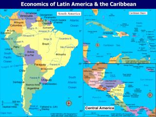
Unit 3 – Latin America 6 th Grade Social Studies Todd Phillips Boyd Elementary. National name: República Argentina President: Cristina Fernández de Kirchner (2007) Government: Republic. Population (2010 est.): 41,343,201

E N D
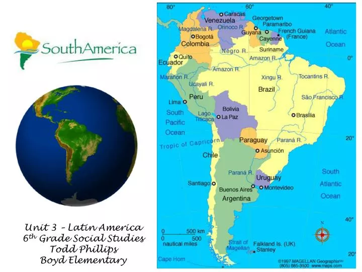
Unit 3 – Latin America 6th Grade Social Studies Todd Phillips Boyd Elementary
National name:República Argentina • President: Cristina Fernández de Kirchner (2007) • Government: Republic. • Population (2010 est.): 41,343,201 • Capital and largest city (2003 est.): Buenos Aires, 13,349,000 (metro. area), 2,768,772 (city proper) • Languages: Spanish (official), English, Italian, German, French
Ethnicity/race: white (mostly Spanish and Italian) 97%, mestizo (mixed white and Amerindian ancestry), Amerindian, or other non-white groups 3% • Religions: nominally Roman Catholic 92% (less than 20% practicing), Protestant 2%, Jewish 2%, other 4% • Location:Southern South America, bordering the South Atlantic Ocean, between Chile and Uruguay • Nat. Holiday: Revolution Day, May 25 • Monetary Unit:: Peso
GEOGRAPHY: • Second only to Brazil in size and population, Argentina is a plain, rising from the Atlantic to the Chilean border and the towering Andes peaks. Aconcagua (22,834 ft., 6,960 m) is the highest peak in the world outside Asia. Argentina is also bordered by Bolivia and Paraguay on the north and by Uruguay and Brazil on the east. The northern area is the swampy and partly wooded Gran Chaco, bordering Bolivia and Paraguay. South of that are the rolling, fertile Pampas, which are rich in agriculture and sheep- and cattle-grazing and support most of the population. Further south is Patagonia, a region of cool, arid steppes with some wooded and fertile sections
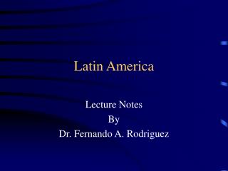
Industries: food processing, motor vehicles, consumer durables, textiles, chemicals and petrochemicals, printing, metallurgy, steel. • Natural resources: fertile plains of the pampas, lead, zinc, tin, copper, iron ore, manganese, petroleum, uranium. • Major trading partners: Brazil, Chile, U.S., China, Spain, Germany (2006). Argentine Gaucho
National name: Plurinational State of Bolivia • President:Evo Morales (2006) • Government: Republic. • Population (2010 est.): 9,947,418 • Historic and judicial capital (2003 est.): Sucre, 204,200; Administrative capital: La Paz, 1,576,100
Languages: Spanish, Quechua, Aymara (all official) • Ethnicity/race: Quechua 30%, mestizo 30%, Aymara 25%, white 15% • National Holiday: Independence Day, August 6 • Religion: Roman Catholic 95%, Protestant (Evangelical Methodist) 5% • Monetary unit: Boliviano
GEOGRAPHY: • Landlocked Bolivia is equal in size to California and Texas combined. Brazil forms its eastern border; its other neighbors are Peru and Chile on the west and Argentina and Paraguay on the south. The western part, enclosed by two chains of the Andes, is a great plateau—the Altiplano, with an average altitude of 12,000 ft (3,658 m). Almost half the population lives on the plateau, which contains Oruro, Potosí, and La Paz. At an altitude of 11,910 ft (3,630 m), La Paz is the highest administrative capital city in the world. The Oriente, a lowland region ranging from rain forests to grasslands, comprises the northern and eastern two-thirds of the country. Lake Titicaca, at an altitude of 12,507 ft (3,812 m), is the highest commercially navigable body of water in the world.
Industries: mining, smelting, petroleum, food and beverages, tobacco, handicrafts, clothing. • Natural resources: tin, natural gas, petroleum, zinc, tungsten, antimony, silver, iron, lead, gold, timber, hydropower. • Major trading partners: Brazil, U.S. Venezuela, Peru, Argentina, Colombia, Chile, China, Japan (2004).
National name:Federal Republic of Brazil • President:DilmaRousseff (2011) • Government: Republic. • Population (2010 est.): 201,103,330 • Capital (2003 est.): Brasília, 2,160,100 • Languages: Portuguese (official), Spanish, English, French
Ethnicity/race: white 53.7%, mulatto (mixed white and black) 38.5%, black 6.2%, other (includes Japanese, Arab, Amerindian) 0.9%, unspecified 0.7% (2000) • National Holiday: Independence Day, September 7 • Religion: Roman Catholic 74%, Protestant 15%, Spiritualist 1%, none 7% (2000) • Monetary unit:Real
GEOGRAPHY: • Brazil covers nearly half of South America and is the continent's largest nation. It extends 2,965 mi (4,772 km) north-south, 2,691 mi (4,331 km) east-west, and borders every nation on the continent except Chile and Ecuador. Brazil may be divided intothe BrazilianHighlands, or plateau, in the south and the Amazon River Basin in the north. Over a third of Brazil is drained by the Amazon and its more than 200 tributaries. The Amazon is navigable for ocean steamers to Iquitos, Peru, 2,300 mi (3,700 km) upstream. SouthernBrazil is drained by the Plata system—the Paraguay, Uruguay, and Paraná rivers.
Industries: textiles, shoes, chemicals, cement, lumber, iron ore, tin, steel, aircraft, motor vehicles and parts, other machinery and equipment. • Natural resources: bauxite, gold, iron ore, manganese, nickel, phosphates, platinum, tin, uranium, petroleum, hydropower, timber. • Major trading partners: U.S., Argentina, China, Netherlands, Germany, Mexico, Nigeria, Japan (2005).
National name: Republic of Chile • President:SebastiánPiñera (since 2010) • Government: Republic. • Population (2010 est.): 16,746,491 • Capital and largest city (2003 est.): Santiago, 5,333,100 • Language:Spanish
Ethnicity/race: white and white-Amerindian 95%, Amerindian 3%, other 2% • National Holiday: Independence Day, September 18 • Religions: Roman Catholic 89%, Protestant 11%, small Jewish population • Monetary unit: Chilean Peso
GEOGRAPHY: • Situated south of Peru and west of Bolivia and Argentina, Chile fills a narrow 2,880-mi (4,506 km) strip between the Andes and the Pacific. One-third of Chile is covered by the towering ranges of the Andes. In the north is the driest place on Earth, the Atacama Desert, and in the center is a 700-mile-long (1,127 km) thickly populated valley with most of Chile's arable land. At the southern tip of Chile's mainland is Punta Arenas, the southernmost city in the world, and beyond that lies the Strait of Magellan and Tierra del Fuego, an island divided between Chile and Argentina.
GEOGRAPHY CONT.: • The southernmost point of South America is Cape Horn, a 1,390-foot (424 m) rock on Horn Island in the Wollaston group, which belongs to Chile. Chile also claims sovereignty over 482,628 sq mi (1,250,000 sq km) of Antarctic territory; the Juan Fernández Islands, about 400 mi (644 km) west of the mainland; and Easter Island, about 2,000 mi (3,219 km) west
Industries: copper, other minerals, foodstuffs, fish processing, iron and steel, wood and wood products, transport equipment, cement, textiles. • Natural resources: copper, timber, iron ore, nitrates, precious metals, molybdenum, hydropower. • Major trading partners: U.S., Japan, China, South Korea, Netherlands,Brazil, Italy, Mexico, Argentina (2004).
National name: Republic of Colombia • President: Juan Manuel Santos (2010) • Population (2010 est.):44,205,293 • Capital and largest city (2003 est.):Santafé de Bogotá, 7,594,000
Language: Spanish • Ethnicity/race: mestizo 58%, white 20%, mulatto 14%, black 4%, mixed black-Amerindian 3%, Amerindian 1% • National Holiday: Independence Day, July 20 • Religion: Roman Catholic 90% • Monetary unit: Colombian Peso
GEOGRAPHY: • Colombia is bordered on the northwest by Panama, on the east by Venezuela and Brazil, and on the southwest by Peru and Ecuador. Through the western half of the country, three Andean ranges run north and south. The eastern half is a low, jungle-covered plain, drained by spurs of the Amazon and Orinoco Rivers, inhabited mostly by isolated tropical-forest Indian tribes. The fertile plateau and valley of the eastern range are the most densely populated parts of the country.
Industries:textiles, food processing, oil, clothing and footwear, beverages, chemicals, cement; gold, coal, emeralds. • Natural resources: petroleum, natural gas, coal, iron ore, nickel, gold, copper, emeralds, hydropower • Major trading partners: U.S., Venezuela, Ecuador, China, Mexico, Brazil (2004).
National name: Republic of Ecuador • President: Rafael Correa (2007) • Government: Republic. • Population (2011 est.): 15,007,343 • Capital (2009 est.): Quito 1,801,000 • Languages: Spanish (official), Quechua, other Amerindian languages
Ethnicity/race: mestizo (mixed Amerindian and white) 65%, Amerindian 25%, Spanish and others 7%, black 3% • National Holiday: Independence Day, August 10 • Religion: Roman Catholic 95% • Monetary unit: U.S. dollar
GEOGRAPHY: • Ecuador, about equal in area to Nevada, is in the northwest part of South America fronting on the Pacific. To the north is Colombia and to the east and south is Peru. Two high and parallel ranges of the Andes, traversing the country from north to south, are topped by tall volcanic peaks. The highest is Chimborazo at 20,577 ft (6,272 m). The Galápagos Islands (or Colón Archipelago: 3,029 sq mi; 7,845 sq km), in the Pacific Ocean about 600 mi (966 km) west of the South American mainland, became part of Ecuador in 1832.
Industries: petroleum, food processing, textiles, wood products, chemicals. • Natural resources: petroleum, fish, timber, hydropower. • Major trading partners: U.S., Peru, Italy, Colombia, Brazil, Chile, Panama (2006).
Status: Overseas Department – France • Prefect: Jean-Pierre Laflaquière (2006) • Population (2007 est.):203,321 • Capital and largest city (2003 est.): Cayenne, 60,500 • Language:French • Religion: Roman Catholic • Monetary unit: Franc
Ethnicity/race: black or mulatto 66%, white 12%, East Indian, Chinese, Amerindian 12%, other 10% • Industries: construction, shrimp processing, forestry products, rum, gold mining. • Natural resources: bauxite, timber, gold (widely scattered), cinnabar, kaolin, fish. • Major trading partners: France, Switzerland, U.S., Trinidad and Tobago, Italy (2004).
GEOGRAPHY: • French Guiana, lying north of Brazil and east of Suriname on the northeast coast of South America, was variously settled by the Spanish, Dutch, and French. The Treaty of Breda awarded France the territory in 1667. The French used it as a penal colony between 1852 and 1939, which included the infamous Devil's Island. In 1947 it became an overseas department of France. Since then, many indigenous French Guianians have called for increased autonomy, although only around 5% favor independence from France, partly due to the vast subsidies from the French government. The European Space Center at Kourou has brought a corner of French Guiana into the modern world and attracted a sizable expatriate workforce.
National name: Co-operative Republic of Guyana • President:BharratJagdeo (1999) • Government: Republic. • Population (2010 est.): 748,486 • Capital and largest city (2003 est.): Georgetown, 227,700 • Languages: English (official), Amerindian dialects, Creole, Hindi, Urdu
Ethnicity/race: East Indian 50%; black 36%; Amerindian 7%; white, Chinese, and mixed 7% • National Holiday: Republic Day, February 23 • Religions: Christian 50%, Hindu 35%, Islam 10%, other 5% • Monetary unit: Guyanese dollar
GEOGRAPHY: • Guyana is the size of Idaho and is situated on the northern coast of South America, east of Venezuela, west of Suriname, and north of Brazil. A tropical forest covers more than 80% of the country. • Industries: bauxite,sugar, rice milling, timber, textiles, gold mining. • Natural resources: bauxite, gold, diamonds, hardwood timber, shrimp, fish. • Major trading partners: Canada, U.S., Netherlands, UK, Portugal, Belgium, Jamaica, Trinidad and Tobago, Cuba (2006).
National name: Republic of Paraguay • President: Fernando Lugo (2008) • Government: Constitutional republic. • Population (2009 est.): 6,995,655 • Capital and largest city (2003 est.): Asunción, 1,482,200 (metro. area
Languages: Spanish, Guaraní (both official) • Ethnicity/race: mestizo 95% • Religions: Roman Catholic 90%, Mennonite, other Protestant 10% • Monetary unit: Guarani
GEOGRAPHY: • California-size Paraguay is surrounded by Brazil, Bolivia, and Argentina in south-central South America. Eastern Paraguay, between the Paraná and Paraguay rivers, is upland country with the thickest population settled on the grassy slope that inclines toward the Paraguay River. The greater part of the Chaco region to the west is covered with marshes, lagoons, dense forests, and jungles.
Industries: sugar, cement, textiles, beverages, wood products, steel, metallurgic, electric power. • Natural resources: hydropower, timber, iron ore, manganese, limestone. • Major trading partners: Uruguay, Brazil, Argentina, Switzerland, China, U.S. (2004).
National name: Republic of Perú • President:OllantaHumala (July 2011) • Government: Constitutional republic. • Population (July 2011 est.): 29,248,943 • Capital and largest city (2009 est.): Lima, 8.769 million
Languages: Spanish, Quéchua (both official); Aymara; many minor Amazonian languages • Ethnicity/race: Amerindian 45%, mestizo 37%, white 15%, black, Japanese, Chinese, and other 3% • Religion: Roman Catholic 81.3%, Evangelical 12.5%, other%, unspecified or none 2.9% (2007 est.) • Monetary unit: Nuevo sol (1991)