Download
1 / 19
190 likes | 191 Views
This article discusses the use of GeoServer and Virtual Globes to map glacier data and photographs, including an overview of the Glacier Photograph Collection, Google Earth demonstration, and the availability of the World Glacier Inventory as a KML file through GeoServer.

E N D
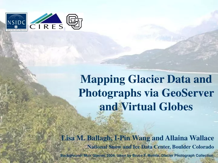
Mapping Glacier Data and Photographs via GeoServer and Virtual Globes Lisa M. Ballagh, I-Pin Wang and Allaina Wallace National Snow and Ice Data Center, Boulder Colorado Background: Muir Glacier, 2004, taken by Bruce F. Molnia, Glacier Photograph Collection
Overview • Glacier Photograph Collection • Glacier data sets • Google Earth demonstration • GeoServer overview • NSIDC’s Virtual Globes site • GLIMS • Fluctuations of Glaciers World Glacier Inventory
Glacier Photograph Collection • Coverage primarily includes • Alaska and Greenland • Doubled in size since Jan. 31, 2008 • USGS Ice and Climate Project • Contributions from Austin Post • 10,000+ photographs online
Arapaho Glacier Jon Van de Grift August 2004 Junius Henderson September 1912 Henry A Waldrop September 1966
Repeat Photography Holgate Glacier Bruce F. MolniaAugust 2004 Ulysses S. GrantJuly 1909
World Glacier Inventory (WGI) • Online database of 100,000+ glaciers • Snapshot of glacier data including • Latitude/longitude • Total area • Mean depth • Photo year • Topographic scale • and more... • http://nsidc.org/data/g01130.html
WGI in Google Earth • Objective: Make WGI data accessible from Google Earth (or another Virtual Globe) • Problem: Data set size would create an unreasonably large static KML file • Solution: Dynamically request area-specific WGI data from GeoServer
WGI KML SQL Server OpenLayers PDF MySQL GeoServer Input Output PostGIS KML Oracle SVG Shapefile GeoRSS
At the Heart: GeoServer • Open source server • Key: interoperability • Supports OGC standards • “Share and edit geospatial data” • GUI-driven
GeoServer Google Earth • Auto-generated KML file is user unfriendly • Use templates and Styled Layer Descriptors (SLDs) to customize the output in KML • Create a KML template • Helps with data presentation • Develop a Styled Layer Descriptor • Snowflake Placemarks
GeoServer • Example SLD
GeoServer • Example KML template (description.ftl)
NSIDC’s Virtual Globes Site • http://nsidc.org/data/virtual_globes/
Summary • Glacier Photograph Collection has doubled • WGI now available as a KML file • GeoServer helps serve data through Google Earth • Users can view two data sets in a spatial environment • Thanks to NOAA’s National Geophysical Data Center • Questions/comments: • Lisa Ballagh (vtlisa@nsidc.org)