Download
1 / 37
370 likes | 470 Views
INITIATION OF AIRMASS DEEP MOIST CONVECTION. Thomas Krennert, t.krennert@zamg.ac.at , Central Institute of Meteorology and Geodynamics, Vienna, Austria. University Vienna, Institute of Meteorology EU project HERA / MAP Satellite department @ ZAMG – SATMANU Forecaster since 2004

E N D
INITIATION OF AIRMASS DEEP MOIST CONVECTION Thomas Krennert, t.krennert@zamg.ac.at, Central Institute of Meteorology and Geodynamics, Vienna, Austria
University Vienna, Institute of Meteorology EU project HERA / MAP Satellite department @ ZAMG – SATMANU Forecaster since 2004 Late activities: Weather type classification (COST733, KLI_EN) Trusted Spotter Network Austria (ZAMG, Skywarn, ESSL / ESWD, meteopics.eu) INITIATION OF AIRMASS DMC CONVECTION WEEK 2011 THOMAS KRENNERT INTRO
INITIATION OF AIRMASS DMC CONVECTION WEEK 2011 THOMAS KRENNERT OUTLINE • Forecasting: case study & task • Limitations of forecaster regarding initiation of airmass / pulse DMC • Integrating upper level dynamics / moisture gradients / MSG WV • Concept of symmetric instabilities • Derivation of a geostrophic wind-vector-gradient matrix • RGB testing
INITIATION OF AIRMASS DMC CONVECTION WEEK 2011 THOMAS KRENNERT FORECAST CASE STUDY: SYNOPTIC BACKGROUND, 28 July 2005 MSLP (VIOLET), H500 (CYAN)
INITIATION OF AIRMASS DMC CONVECTION WEEK 2011 THOMAS KRENNERT FORECAST CASE STUDY: SYNOPTIC BACKGROUND THETAe surface (red), 850 hPa (yellow)
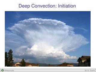
CONVECTIVE INITIATION CONVECTION WEEK 2011 THOMAS KRENNERT FORECAST CASE STUDY: MSG HRVIS LOOP
INITIATION OF AIRMASS DMC CONVECTION WEEK 2011 THOMAS KRENNERT FORECAST CASE STUDY: TASK • @ 1130 UTC: where exactly will DMC occur? • Transition from shallow convection towards DMC? • Ingredients based methodology: Instability – moisture – lift • Clear and proven concept • Local variability of moisture supply, entrainment, CIN • Sufficient quantities of ingredients to resolve CIN / inversions? • About 20 - 30% seasonal convective activity of this type / Alpine region
INITIATION OF AIRMASS DMC CONVECTION WEEK 2011 THOMAS KRENNERT FORECAST CASE STUDY: OPERATIONALLY AVAILABLE PRODUCTS • MSG / Nowcasting • 3.9μ / 6.2μ / 7.3μ - RGB • Severe Storm RGB • Air Mass RGB • Clout Top Height • Microphysics / day • Global / Regional Instability Index • Multisensor Precipitation + NWCSAF precipitation products • NWCSAF products i.e. RTD • RADAR (no signal so far), TEMP • NWP – models: DMO + post processing • Low – res, local, high – res non hydrostatic, hybrids: artefacts ? • High resolusion analysis and nowcasting:
INITIATION OF AIRMASS DMC CONVECTION WEEK 2011 THOMAS KRENNERT FORECAST CASE STUDY: NOWCASTING, INCA ANALYSIS
INITIATION OF AIRMASS DMC CONVECTION WEEK 2011 THOMAS KRENNERT NOWCASTING, ALADIN – SURFACE MOCON FORECAST 1200 UTC
INITIATION OF AIRMASS DMC CONVECTION WEEK 2011 THOMAS KRENNERT FORECAST CASE STUDY: RASO VIENNA 1200 UTC
INITIATION OF AIRMASS DMC CONVECTION WEEK 2011 THOMAS KRENNERT FORECAST CASE STUDY: MSG HRVIS LOOP - CONTINUED
INITIATION OF AIRMASS DMC CONVECTION WEEK 2011 THOMAS KRENNERT FORECAST CASE STUDY: MSG WV 6.2µ LOOP
INITIATION OF AIRMASS DMC CONVECTION WEEK 2011 THOMAS KRENNERT UPPER LEVEL PROPERTIES: EQUIVALENT POTENTIAL TEMPERATURE • Theta-e gradient slightly indicated, dry intrusion, conditional instability increasing, CAPE increasing? 300 hPa 500 hPa
INITIATION OF AIRMASS DMC CONVECTION WEEK 2011 THOMAS KRENNERT JET INDICATOR, SHEAR VORTICITY – ZERO LINE • Zero line shear indicates vertical wind speed gradient (min+max) SANTURETTE, P., GEORGIEV, C. G., 2005; MARTIN, et al., 1999 300 hPa 500 hPa
INITIATION OF AIRMASS DMC CONVECTION WEEK 2011 THOMAS KRENNERT UPPER LEVEL PROPERTIES: POTENTIAL VORTICITY / PVA 300 Isopleths 1,5 PVU at respective pressure level – „dry intrusion“ PVA 300 hPa
INITIATION OF AIRMASS DMC CONVECTION WEEK 2011 THOMAS KRENNERT INDICATIONS FOR SYMMETRIC INSTABILITY • ECMWF 0.5 parameter: Equivalent potential Vorticity (layer 850 – 500 hPa) • Mostly negative (dashed lines) • Leading to consideration of the concept of Symmetric instabilities
INITIATION OF AIRMASS DMC CONVECTION WEEK 2011 THOMAS KRENNERT COMPARISON OF INSTABILITIES Schultz and Schumacher (1999)
INITIATION OF AIRMASS DMC CONVECTION WEEK 2011 THOMAS KRENNERT CONCEPT SKETCH COMET: Slantwise convection
INITIATION OF AIRMASS DMC CONVECTION WEEK 2011 THOMAS KRENNERT REVIEW: CHARACTERISTICS • Schultz and Schumacher (1999): • convection can possess characteristics of slantwise convection, gravitational convection, or both • Coexistence of: CSI/PSI, CI/PI, adequate moisture / lift • Release of convective–symmetric instability results in a mixture of moist slantwise convection and moist gravitational - the latter prevails • CI / PI is a special case of CSI / PSI in which θes / θ surfaces not only tilt more steeply than Mg surfaces, but are overturned • Hoskins (1974), Mc Cann (1995): • Mg – θ relationship for dry symmetric instability is equivalent to geostrophic potential vorticity PVg • Limitations: • identifying regions with PVg / MPVg might also indicate PI / CI and gravitational convection
INITIATION OF AIRMASS DMC CONVECTION WEEK 2011 THOMAS KRENNERT REVIEW: COEXISTENCE OF SI & GRAVITATIONAL INSTABILITIES • Xu (1986a): “upscale development,”: • Initial development of small-scale moist gravitational convection • release of symmetric instability -> mesoscale banded convective clouds • most likely occurrence : outside of frontal regions, absence of synoptic-scale air mass boundaries. • Jascourt et al. (1988): • scattered cumulus cloud bands simultaneously grew into lines of thunderstorms • along the 700–500-mb shear, layer with weak moist symmetric stability • conditionally unstable to gravitational convection (CAPE > 1000 J kg−1) • nature and organization of convection can be modulated by the symmetric stability
Distinct vertical shear / little directional shear Weak gravitational stability MPVg becoming smaller or negative by deformation at the boundary zone Strong thermal gradient induced by the dry and cold intrusion along with the WV dark zone Saturated buoyant air parcel reaches a zone of distinct negative MPVg Release of SI -> slantwise convection might follow (cms-1), sufficient? INITIATION OF AIRMASS DMC CONVECTION WEEK 2011 THOMAS KRENNERT INDICATIONS FOR SI @ UPPER LEVEL WV BOUNDARIES - SUMMARY
The calculation of Mg – θ relationship (Dixon, 2000): Cartesian coordinates necessary not easily used in operational forecasting The calculation of SCAPE Also no frequent use in operational forecasting The calculation of MPVg <0 / increase or decrease of its gradient “Horizontal gradients of conservative field quantities (such as: P, Pe, Θe) are strengthened by the geostrophic wind field when deformation terms are dominant” (Bluestein 1993, Houze 1993, Emanuel 1994) -> Derivation of a geostrophic wind-vector-gradient matrix (“NUE”) INITIATION OF AIRMASS DMC CONVECTION WEEK 2011 THOMAS KRENNERT INDICATORS FOR SYMMETRIC INSTABILITIES (LITERATURE)
INITIATION OF AIRMASS DMC CONVECTION WEEK 2011 THOMAS KRENNERT NUE MATRIX divergence stretching deformation shearing deformation relative vorticity • http://www.nwcsaf.org/HD/files/vsadoc/vsa_report_tk.pdf
Only the negative values of the NUE – parameter indicate strengthening of the MPV – gradient. In order to avoid imaginary results the parameter is calculated In combination with the WV gradients a zone for favourable DMC onset can be highlighted (easily applied operationally) INITIATION OF AIRMASS DMC CONVECTION WEEK 2011 THOMAS KRENNERT PROPERTIES OF NUE
INITIATION OF AIRMASS DMC CONVECTION WEEK 2011 THOMAS KRENNERT PROPERTIES OF NUE: CASE STUDY
INITIATION OF AIRMASS DMC CONVECTION WEEK 2011 THOMAS KRENNERT ALADIN MPVg (850-500hPa), NUE 850 / 700 / 500 hPa, 0600UTC 850 hPa 700 hPa 500 hPa
INITIATION OF AIRMASS DMC CONVECTION WEEK 2011 THOMAS KRENNERT ALADIN MPVg (850-500hPa), NUE 850 / 700 / 500 hPa, 1200UTC 850 hPa 700 hPa 500 hPa
INITIATION OF AIRMASS DMC CONVECTION WEEK 2011 THOMAS KRENNERT CASE STUDY: FURTHER DEVELOPMENT 1800 UTC 1500 UTC
INITIATION OF AIRMASS DMC CONVECTION WEEK 2011 THOMAS KRENNERT RGB: IR 8.7µ / WV 7.3µ / WV 6.2µ
INITIATION OF AIRMASS DMC CONVECTION WEEK 2011 THOMAS KRENNERT RGB: IR 8.7µ / WV 7.3µ / WV 6.2µ
INITIATION OF AIRMASS DMC CONVECTION WEEK 2011 THOMAS KRENNERT RGB: IR 8.7µ / WV 7.3µ / WV 6.2µ
INITIATION OF AIRMASS DMC CONVECTION WEEK 2011 THOMAS KRENNERT RGB: IR 8.7µ / WV 7.3µ / WV 6.2µ
INITIATION OF AIRMASS DMC CONVECTION WEEK 2011 THOMAS KRENNERT RGB: IR 8.7µ / WV 7.3µ / WV 6.2µ
INITIATION OF AIRMASS DMC CONVECTION WEEK 2011 THOMAS KRENNERT RGB: IR 8.7µ / WV 7.3µ / WV 6.2µ
INITIATION OF AIRMASS DMC CONVECTION WEEK 2011 THOMAS KRENNERT RGB: IR 8.7µ / WV 7.3µ / WV 6.2µ LOOP
References Bluestein, H. B., 1993: Synoptic-Dynamic Meteorology in Midlatitudes. Volume II: Observations and Theory of Weather Systems. Oxford University Press, section 3.5.2. Dixon, R. S., 2000: Diagnostic studies of symmetric instability. Ph.D. dissertation, University of Reading, 128 pp. [Available from Department of Meteorology, University of Reading, Earley Gate, P.O. Box 243, Reading RG6 6BB, United Kingdom.]. Emanuel, K. A., 1994: Atmospheric Convection. Oxford University Press, chapter 12. Hoskins, B. J., 1974: The role of potential vorticity in symmetric stability and instability. Quart. J. Roy. Meteor. Soc,100, 480 ff. Houze, R. A. Jr., 1993: Cloud Dynamics. Academic Press, section 2.9.1. Jascourt, S. D, S. S. Lindstrom, C. J. Seman, and D. D. Houghton, 1988: An observation of banded convective development in the presence of weak symmetric stability. Mon. Wea. Rev.,116, 175 ff. MARTIN, F., Elizaga, F., Riosalido, R., 1999: The Mushroom Configuration in Water Vapour Imagery and Operational Applications. Meteorol. Appl., 6, 143 ff. McCANN, D. W., 1995: Three-dimensional computations of equivalent potential vorticity. Wea. Forecasting,10, 798 ff. SANTURETTE, P., GEORGIEV, C. G., 2005: Weather Analysis and Forecasting – Applying Satellite Water Vapour Imagery and Potential Vorticity Analysis, Elsevier Academic Press Schultz, D. M., and P. N. Schumacher, 1999: The use and misuse of conditional symmetric instability. Mon. Wea. Rev.,127, 2709 ff; Corrigendum, 128, 1573. XU, Q., 1986: Conditional symmetric instability and mesoscale rainbands. Quart. J. Roy. Meteor. Soc.,112, 315 ff. INITIATION OF AIRMASS DMC CONVECTION WEEK 2011 THOMAS KRENNERT THANK YOU!