Download
1 / 30
430 likes | 815 Views
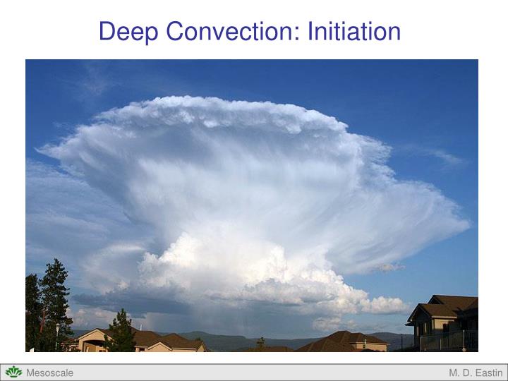
Deep Convection: Initiation. Deep Convection: Initiation. Convective Initiation Big Picture Boundary Layer Basics Boundary Layer Convection Initiation on the Mesoscale. Deep Convection: Initiation. Convective Initiation: Where and when will moist convection develop?

E N D
Deep Convection: Initiation M. D. Eastin
Deep Convection: Initiation • Convective Initiation • Big Picture • Boundary Layer Basics • Boundary Layer Convection • Initiation on the Mesoscale M. D. Eastin
Deep Convection: Initiation • Convective Initiation: Where and when will moist • convection develop? • Importance: • Quantitative Precipitation Forecasts (QPF) • Severe Weather Forecasting • Hydrology (flash flooding, stream levels) • Aviation Forecasting (microbursts) Storm Initiation Locations during 3-month study of the Denver Convergence Zone (DCZ) Cheyenne Ridge DCZ From Wilson and Schrieber (1986) Palmer Divide M. D. Eastin
Deep Convection: Initiation • Atmospheric Structure • Potentially Unstable: • Deep convection is not automatic • Contain some CAPE (positive area), • but often located above CIN (negative area) • Air must be physically lifted to the LFC • Convection must be initiated, or “triggered” • by “local” regions of enhanced ascent • Mechanisms that can trigger deep convection: • Synoptic-scale fronts • Mesoscale fronts (drylines and gust fronts) • How do we get convection away from fronts? • What initiates the first gust-front producing storm? • Do all “boundaries” produce deep convection? CAPE LFC CIN M. D. Eastin
The Boundary Layer • Structure and Evolution • Definition: The part of the atmosphere directly influenced by the Earth’s surface that • responds to surface forcing (i.e. friction and energy fluxes) within a time scale of ~1 hour or less • Sub-layers: • Surface Layer • Mixed Layer (ML) • Entrainment Zone (EZ) • Stable Boundary Layer (SBL) • Residual Layer (RL) Common parameters used to study and locate the boundary layer: • Temperature (T) • Mixing ratio (w) • Potential Temperature (θ) • Remember: Both θ and w are conserved (constant) for dry adiabatic processes M. D. Eastin
The Boundary Layer • Structure and Evolution • In the absence of frontal forcing (i.e., under high pressure systems): • Evolves in a well-defined manner • Daily cycle is very pronounced and regular • Surface Layer: Lowest ~100 m AGL • Layer where heat and moisture are exchanged between land and air • Strong vertical gradients in winds, temperature, and moisture • Stability often super-adiabatic (daytime) M. D. Eastin
The Boundary Layer Structure and Evolution Late Afternoon After Sunset Before Sunrise Early Morning Mid-Morning Potential Temperature Temperature M. D. Eastin
The Boundary Layer Structure and Evolution Mixed Layer: Located above the surface layer during the day Depth ~1000 m Overturning thermals regularly transport (or “mix”) heat and moisture from the surface layer to the entrainment zone Mixing often strongest ~1-2 hours after solar noon Heat and moisture are conserved (θ and w are constant) Stability often dry-adiabatic M. D. Eastin
The Boundary Layer Structure and Evolution Late Afternoon After Sunset Before Sunrise Early Morning Mid-Morning Potential Temperature Temperature M. D. Eastin
The Boundary Layer Convection in the Mixed Layer Vertically point airborne cloud radar (95Ghz) Radar echo due to insects in NW Oklahoma + = Top of BL M. D. Eastin
The Boundary Layer Structure and Evolution Entrainment Zone: Located above the mixed-layer during the day Depth ~100-200 m Transition layer between the well-mixed convective boundary layer and the free atmosphere Strong vertical gradients in temperature and moisture Often contains a temperature inversion (source of CIN) Stability often absolutely stable (prevents cloud growth) Strong inversions will prevent deep convection M. D. Eastin
The Boundary Layer Structure and Evolution Late Afternoon After Sunset Before Sunrise Early Morning Mid-Morning Potential Temperature Temperature M. D. Eastin
The Boundary Layer Structure and Evolution Stable Boundary Layer: Depth ~100-500 m Radiational cooling of the land creates a stable cold layer Layer deepens as night progress (no vertical mixing) Strong temperature inversion at top Residual Layer:Remnant mixed layer Capping Inversion: Remnant entrainment zone M. D. Eastin
The Boundary Layer Structure and Evolution Late Afternoon After Sunset Before Sunrise Early Morning Mid-Morning Potential Temperature Temperature M. D. Eastin
q The Boundary Layer Structure and Evolution • Daytime sounding from • Amarillo, Texas • Can you identify each of the • regions just discussed? • Surface Layer • Mixed Layer • Entrainment Zone M. D. Eastin
q The Boundary Layer Structure and Evolution • Night time sounding from • Amarillo, Texas • Can you identify each of the • regions just discussed? • Stable Boundary Layer • Residual Layer M. D. Eastin
Boundary Layer Convection • Why does it occur? • Transport heat and moisture from the surface to the free atmosphere • Two common scenarios for boundary layer convection: Daytime Solar Heating Cold Air Advection M. D. Eastin
Boundary Layer Convection • What is the result of the convection? • Shallow clouds often occur from noon to late afternoon • “Popcorn” or “Fair-Weather” cumulus • Clouds can appear random, but are often • organized into distinct structures • “Cloud Streets” • “Open/Closed Cells” M. D. Eastin
Boundary Layer Convection • Horizontal Convective Rolls (HCRs): • Due to daytime solar heating of land • Mixed-layer thermals organized into bands • Horizontal helices oriented nearly parallel • to the ambient flow • Produce cloud streets • Commonly seen in satellite and radar • imagery prior to the onset of deep • convection (useful to forecasters) From Houze (1993) M. D. Eastin
Boundary Layer Convection • Horizontal Convective Rolls (HCRs): • Typical aspect ratio (horizontal to • vertical scale) is 3:1 but can vary • from 2:1 to 10:1 • Typical updrafts are 1-3 m/s • Updrafts often contain higher values • of T, θ, and w compared to adjacent • downdrafts • Result from a combination of buoyancy • and vertical wind shear within the • boundary layer • Most often occur in strong shear, • moderate heat flux environments • (the same environment most • severe weathers occurs in…) M. D. Eastin
Boundary Layer Convection • Horizontal Convective Rolls (HCRs): • If updrafts contain higher T, θ, and w then there should be less negative area (CIN) • to overcome and more positive area (CAPE) available for deep convection • On radar, higher reflectivity cells often correspond to the “deeper” convection • along the bands that are more likely to reach their LFC and “trigger” the first • deep convection (helpful for short–term forecasts) M. D. Eastin
Boundary Layer Convection • Horizontal Convective Rolls (HCRs): • Along-band periodicity is often observed • in the shallow clouds • Called “pearls on a necklace” • Believed to be caused by gravity waves • propagating along the temperature • inversion of the entrainment zone From Christian (1987) M. D. Eastin
Boundary Layer Convection • Open Cell Convection • Due to advection of cold air over a warm • surface (either land or water) • Common late fall thru early summer (over land) • Cell has hexagonal structure (aspect ratio 10:1) • Descending motion at the core • Updrafts on edge are ~1 m/s • Form in weak shear environments • Well observed by satellites (visible) • Difficult to detect on radar (looks like • random “noise”) • Can trigger deep convection Visible Satellite Image of Labrador Sea M. D. Eastin
Boundary Layer Convection • Closed Cell Convection • Often occurs over cold surfaces • (e.g. stratocumulus off California coast) • Forced by strong radiational cooling at cloud top • Cell has hexagonal structure • Ascending motion at the core • Form in weak shear environments with minimal • surface fluxes • Rarely triggers deep convection Visible Satellite Image M. D. Eastin
Boundary Layer Convection • Non-homogeneous Surface Conditions: • Acts to modulate (or slightly alter) the • convection generated by both solar • heating and/or cold air advection • Strong gradient in surface properties M. D. Eastin
Convective Initiation on the Mesoscale • Given: • A synoptic-scale environment conducive to deep convection (e.g. ample CAPE) • Some CIN which must be “overcome” to permit deep convection • Required: • “Boundaries” are needed to provide mesoscale regions of forced ascent • Not all boundaries produce deep convection • Deep convection is often not uniform along a given boundary • Possible Boundaries: • Synoptic fronts and troughs • Dry Lines • Coastal fronts and sea breezes • Gust fronts • Topographically induced fronts • Boundary Layer Thermals • Horizontal Convective Rolls • Open Cell Convection • Non-homogeneous surface conditions M. D. Eastin
Convective Initiation on the Mesoscale • Often Needed and/or Occurs: • Changes to the thermodynamic profile (i.e. lower CIN and increase CAPE) • Possible Processes: • Differential horizontal temperature advection • Persistent synoptic-scale ascent (unrelated to boundaries) – (a) • Low-level moistening – (b) • Low-level warming – (c) M. D. Eastin
Convective Initiation on the Mesoscale • Forecasts: • Are getting better, but we still have much to learn about convective initiation • The best forecasters continuously monitor thermodynamic (i.e. stability = soundings) • and kinematic (i.e. wind shear) changes along ALL boundaries M. D. Eastin
Deep Convection: Initiation • Summary • Definition • Importance • Contributing Factors • Boundary Layer (basic structure, diurnal evolution) • Boundary Layer Convection • Physical processes • Horizontal convective Rolls • Open cell Convection • Closed Cell Convection • Heterogeneous surface conditions • Convective Initiation on the Mesoscale (requirements) M. D. Eastin
References Christian, T. W., 1987: A comparative study of the relationship between radar reflectivities, Doppler velocities, and clouds associated with horizontal convective rolls. M.S. thesis, Department of Atmospheric Sciences, University of California, Los Angeles, 94 pp Houze, R. A. Jr., 1993: Cloud Dynamics, Academic Press, New York, 573 pp. LeMone, M., 1973: The structure and dynamics of horizontal vorticities in the planetary boundary layer. J. Atmos. Sci.,30, 1077-1091. Stull, R. B., 1988: An Introduction to Boundary Layer Meteorology. Kluwer Academic Publishers, Boston, 666 pp. Weckworth, T. M., J. W. Wilson, R. M. Wakimoto, and N. A. Crook (1997): Horizontal convective rolls: Determining the environmental conditions supporting their existence and characteristics. Mon. Wea. Rev.,125, 505-526. Wilson, J. W., and W. E. Schreiber, 1986: Initiation of convective storms at radar observed boundary-layer convergence lines. Mon. Wea. Rev., 114, 2516–2536. M. D. Eastin