Download
1 / 1
10 likes | 114 Views
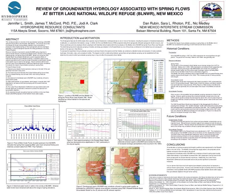
Figure 3 . Historical water levels in wells in the vicinity of BLNWR. Artesian water levels have remained well above the range of spring elevations.

E N D
Figure 3. Historical water levels in wells in the vicinity of BLNWR. Artesian water levels have remained well above the range of spring elevations. Figure 5. Observed and simulated water elevations in the carbonate artesian aquifer at BLNWR demonstrate the effects of increased recharge (precipitation) that occurred in the 1980s. A B Figure 2. Flow at Bitter Creek Flume (located upstream from BLNWR) indicates that spring flow supplying Bitter Lake have remained flowing and relatively constant (data from FWS / Paul Tashjian). Figure 6. Development west of BLNWR may constitute a threat to spring water quality, as illustrated by a MODPATH capture zone analysis computed using OSE’s Roswell Artesian Basin Groundwater Model for the (A) alluvial and (B) artesian aquifers. Figure 4. Total regional pumping in the Roswell Basin Model area has decreased since adjudication in 1967, particularly in the alluvial aquifer. REVIEW OF GROUNDWATER HYDROLOGY ASSOCIATED WITH SPRING FLOWS AT BITTER LAKE NATIONAL WILDLIFE REFUGE (BLNWR), NEW MEXICO Jennifer L. Smith, James T. McCord, PhD, P.E., Jodi A. Clark HYDROSPHERE RESOURCE CONSULTANTS 115A Abeyta Street, Socorro, NM 87801; jls@hydrosphere.com Dan Rubin, Sara L. Rhoton, P.E., Nic Medley NEW MEXICO INTERSTATE STREAM COMMISSION Bataan Memorial Building, Room 101, Santa Fe, NM 87504 INTRODUCTION and MOTIVATION The Endangered Species Act (ESA) states that a species may be threatened or endangered due to one or more of five factors, including the present or threatened destruction, modification, or curtailment of its habitat or range. In 2002, the Fish and Wildlife Service (FWS) proposed listing three springsnails(Roswell springsnail, Koster’s tryonia, and Pecos assiminea)and one amphipod (Noel’s amphipod) with identified critical habitat within the boundaries of the Middle Unit of BLNWR along the Pecos River near Roswell. The 2002 listing document implicates pumping of shallow and deep groundwater in the Roswell Basin as one of the primary contributors to the habitat loss and consequent decline of the species in New Mexico. To evaluate the hypothesis that groundwater pumping is a primary threat to the species and their habitat, we undertook a detailed review and evaluation of newly available hydrologic information, data, and conceptual models. The degree to which a relationship between spring flows and groundwater pumping can be established will help determine the extent to which groundwater pumping may or may not affect the proposed critical habitat. ABSTRACT This review provides an overview of the groundwater hydrology at BLNWR along the Pecos River near Roswell, New Mexico. The primary focus was to evaluate the threat of groundwater depletion due to pumping on proposed critical habitat springs of three springsnails and one amphipod identified in a draft Endangered Species Act listing published in the 2002 Federal Register. Resource indicators examined to assess BLNWR spring response to environmental stresses included groundwater levels, elevation of the critical habitat springs, and spring flows at BLNWR. Model runs using the OSE Roswell Basin Groundwater Model were used to separate effects of historical drought from groundwater pumping. A transient capture zone analysis was performed to examine areas of potential contamination threats to the aquifer source area for the springs. Future scenarios without and with the Lower Pecos Adjudication Settlement Agreement were considered to evaluate the impact of groundwater pumping on spring flows. Principal findings include: (1) Regional groundwater levels reached a minimum in the late 1970s and generally have been rising since. (2) The historical record indicates that critical habitat spring source flows have not ceased flowing since at least 1940, even during historical droughts. (3) Development immediately west of BLNWR may constitute a threat to spring water quality. (4) State administration of groundwater, which began in earnest after 1967 adjudication, will assure that future pumping will not exceed historical maximums. (5) The Lower Pecos Adjudication Settlement and associated actions will provide significant conservation measures to protect the species from groundwater depletion. (6) An extended drought exceeding historical conditions is the most likely threat to BLNWR proposed critical habitat’s future water supply. • METHODS • To evaluate the impact of groundwater pumping on spring flows on the Middle Unit of BLNWR, we considered the hydrology in both historical and future contexts. • Historical Conditions • Precipitation • Since BLNWR founding in 1937, the 1950s represents the most significant drought period. The period from the early-1980s to mid-1990s was generally wet. • Resource Indicators • Spring Flows • The elevation of the proposed critical habitat source springs ranges from 3,470 to 3,490 feet.Balleau et al. (1996; 1999) developed a conceptual model suggesting that essentially all spring discharge at BLNWR Middle Unit results from upwelling of artesian aquifer waters into the surface water hydrologic system (including Bitter Creek; flow at the Bitter Creek Flume is illustrated in Figure 2). • The Middle Unit spring complexes which supply BLNWR have not ceased flowing since regular measurements began in the 1940s. This includes periods of heavy pumping and drought. • Groundwater Levels • Artesian water levels were measured at the lowest recorded in 1975, presumably the result of the preceding drought. Water levels in both the artesian and alluvial aquifers have generally been rising since the 1970s (Figure 3). Water levels in the Berrendo artesian well are generally 40 to 60 feet higher than those in the Middle Unit alluvial Well. • Groundwater Pumping • A key concern is the possibility that groundwater pumping represents a threat to the springs. Artesian aquifer pumping has remained relatively constant since the mid-1950s; alluvial aquifer pumping has decreased by about 33% since its peak (Figure 4). Despite the relatively constant pumping in the artesian aquifer, water levels have risen significantly. • The OSE Roswell Basin Model was employedto help disaggregate the effects of pumping from recharge. The “variable recharge” model used measured pumping along with recharge based on precipitation and tributary flow data. The “constant recharge” model used the same pumping record but held recharge constant at the 1967 value. One can interpret the difference between the hydrographs in Figure 5 to indicate the effects of increased recharge in the 1980s. • Future Conditions • Contamination Threats • Threats to the proposed species from surface and groundwater contamination are an important issue. We performed a transient capture zone analysis for both the alluvial and artesian aquifers. Results indicate that development on private lands immediately west of the refuge may constitute a threat to spring water quality (Figure 6). • Groundwater Pumping • Groundwater rights in the Roswell basin were adjudicated in 1967. The implication is that pumping in the BLNWR vicinity will not increase over this adjudicated maximum. • The 2003 Lower Pecos Adjudication Settlement calls for actions which will further decrease pumping stresses on the groundwater system that feeds BLNWR and attempt to bring the aquifers in the basin back into hydrologic balance as it existed according to the Compact’s “1947 Condition.” Bitter Creek Flume Berrendo Well Middle Unit Identified Critical Habitat Areas Figure 1. Location of BLNWR and the Middle Unit along the Pecos River near Roswell, NM. Areas identified as critical habitat for the species are highlighted. • CONCLUSIONS • A combination of extreme pumping and drought conditions was experienced in the Roswell basin in the mid-1970s. The Middle Unit springs that supply water to the proposed critical habitat continued to flow throughout this period. • Development immediately west of BLNWR may constitute a threat to spring water quality. • State administration of groundwater increased after 1967 adjudication and will assure that future pumping will not exceed historical maximums. Additionally, the Lower Pecos Adjudication Settlement and associated actions will provide significant conservation measures. • It is our opinion that future local and regional groundwater pumping does not represent a serious threat to spring flows. A serious and extended drought exceeding historical conditions constitutes a more probable threat to BLNWR proposed critical habitat’s future water supply than groundwater depletion through human activity. • ACKNOWLEDGEMENTS • There were a number of references which were utilized in this review and analysis; all of these full references can be found in the final report (Review of Groundwater Hydrology Associated with Spring Flows at BLNWR, Prepared by Hydrosphere Resource Consultants for NM Interstate Stream Commission, April 2005). Select key references are listed below: • Balleau Groundwater, Inc., 1996, Interrelation of Groundwater and Surface Water at Bitter Lake National Wildlife Refuge, Prepared for U. S. Department of Justice. • Balleau Groundwater, Inc., 1999, Source-Water Protection Zones for Bitter Lake National Wildlife Refuge, Prepared for U. S. Fish and Wildlife Service. • Keyes, E., 2001, Roswell Artesian Basin Groundwater Model Enhancements, Office of the State Engineer Open File Report. • Tashjian, P., U. S. Fish and Wildlife Service hydrologist, 2004, Spreadsheet of mean flow data collected during the period 1995-2003 at Bitter Creek Flume Station.