Download
1 / 1
10 likes | 159 Views
Research Platforms: SwissEx Science. Observing and modelling Winds and Precipitation in Mountainous Terrain. Andrew Clifton 1 , Megan Daniels 2 , Nicholas Dawes 1 , Michael Lehning 1 1. WSL Institute for Snow and Avalanche Research, SLF

E N D
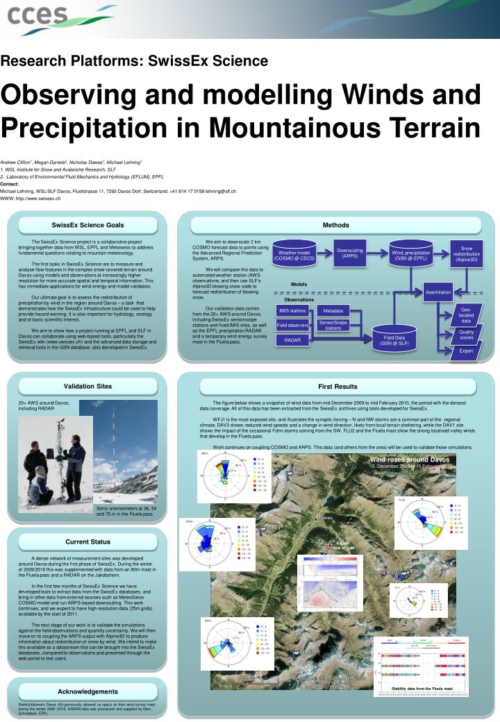
Research Platforms: SwissEx Science Observing and modelling Winds and Precipitation in Mountainous Terrain Andrew Clifton1, Megan Daniels2, Nicholas Dawes1, Michael Lehning1 1. WSL Institute for Snow and Avalanche Research, SLF 2. Laboratory of Environmental Fluid Mechanics and Hydrology (EFLUM), EPFL Contact: Michael Lehning, WSL/SLF Davos, Fluelstrasse 11, 7260 Davos Dorf, Switzerland. +41 814 17 0158 lehning@slf.ch WWW: http://www.swissex.ch Weather model (COSMO @ CSCS) Downscaling (ARPS) Wind, precipitation (GSN @ EPFL) Snow redistribution (Alpine3D) Models Assimilation Observations Geo-located data IMIS stations Metadata Field observers SensorScope stations Quality scores Field Data (GSN @ SLF) RADAR Export First Results Methods Validation Sites SwissEx Science Goals The figure below shows a snapshot of wind data from mid December 2009 to mid February 2010, the period with the densest data coverage. All of this data has been extracted from the SwissEx archives using tools developed for SwissEx. WFJ1 is the most exposed site, and illustrates the synoptic forcing – N and NW storms are a common part of the regional climate. DAV3 shows reduced wind speeds and a change in wind direction, likely from local terrain sheltering, while the DAV1 site shows the impact of the occasional Fohn storms coming from the SW. FLU2 and the Fluela mast show the strong localised valley winds that develop in the Fluela pass. Work continues on coupling COSMO and ARPS. This data (and others from the area) will be used to validate those simulations. 20+ AWS around Davos, including RADAR We aim to downscale 2 km COSMO forecast data to points using the Advanced Regional Prediction System, ARPS. We will compare this data to automated weather station (AWS observations, and then use SLF’s Alpine3D blowing snow code to forecast redistribution of blowing snow. Our validation data comes from the 20+ AWS around Davos, including SwissEx sensorscope stations and fixed IMIS sites, as well as the EPFL precipitation RADAR and a temporary wind energy survey mast in the Fluela pass. The SwissEx Science project is a collaborative project bringing together data from WSL, EPFL and Metoswiss to address fundamental questions relating to mountain meteorology. The first tasks in SwissEx Science are to measure and analyse flow features in the complex snow-covered terrain around Davos using models and observations at increasingly higher resolution for more accurate spatial and temporal information. This has immediate applications for wind energy and model validation. Our ultimate goal is to assess the redistribution of precipitation by wind in the region around Davos – a task that demonstrates how the SwissEx infrastructure could be used to help provide hazard warning. It is also important for hydrology, ecology and of basic scientific interest. We aim to show how a project running at EPFL and SLF in Davos can collaborate using web-based tools, particularly the SwissEx wiki (www.swissex.ch) and the advanced data storage and retrieval tools in the GSN database, also developed in SwissEx. Wind roses around Davos 15 December 2009 to 15 February 2010 Sonic anemometers at 36, 54 and 75 m in the Fluela pass Current Status RADAR field of view A dense network of measurement sites was developed around Davos during the first phase of SwissEx. During the winter of 2009/2010 this was supplemented with data from an 80m mast in the Fluela pass and a RADAR on the Jakobshorn. In the first few months of SwissEx Science we have developed tools to extract data from the SwissEx databases, and bring in other data from external sources such as MeteoSwiss COSMO model and run ARPS-based downscaling. This work continues, and we expect to have high resolution data (25m grids) available by the start of 2011. The next stage of our work is to validate the simulations against the field observations and quantify uncertainty. We will then move on to coupling the ARPS output with Alpine3D to produce information about redistribution of snow by wind. We intend to make this available as a datastream that can be brought into the SwissEx databases, compared to observations and presented through the web portal to test users. Acknowledgements Stability data from the Fluela mast Elektrizitätswerk Davos AG generously allowed us space on their wind survey mast during the winter 2009 /2010. RADAR data was processed and supplied by Marc Schneebeli, EPFL.