Download
1 / 17
180 likes | 367 Views
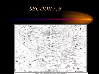
Chapter 3: Nautical Chart. Instructor: Bob Garrison. Selected Questions: Study these for exam. PowerPoint Presentation by Forrest Meiere. S3-3 A projection which preserves correct angular relationships is said to be. conformal.

E N D
Navigation Study Guide Chapter 3: Nautical Chart Instructor: Bob Garrison Selected Questions: Study these for exam PowerPoint Presentation by Forrest Meiere
Navigation Study Guide S3-3 A projection which preserves correct angular relationships is said to be . conformal S3-5 The spherical surface of the earth projected on a series of cones, concentric with the earth's axis and tangent to the sphere of the earth, results in the projection. polyconic S3-6 Which projection is conformal and shows a rhumb line as a straight line? . Mercator
Navigation Study Guide S3-7 In a Mercator projection, the meridians appear as . straight, parallel lines S3-8 In terms of measuring distance along a course or bearing line, does it matter where this distance is measured on a Mercator chart? Yes! Measure on the latitude scale nearest the course. S3-9 How are directions measured on a polyconic Great Lakes chart? . on the nearest compass rose
Navigation Study Guide S3-10 The distance units employed on nautical charts of the Great Lakes are . statute miles S3-11 At a scale of 1:80,000, one inch equals . 80,000 inches If necessary, you can convert to nautical miles if you remember one nautical mile is about 6076 feet. S3-12 What chart types exist? No need to memorize the types of nautical charts; recognize them if you see them. small craft, harbor, coast, general, sailing
Navigation Study Guide S3-13 A large-scale chart offers detail than a small-scale chart. more water depth S3-15 Contour lines connect points of equal on the nautical chart. S3-16 What are bottom types found on a chart. No need to memorize abbreviations; however, learn what some of the more common abbreviations mean. For example, “S” means “sandy”
Navigation Study Guide S3-17 Clearances of bridges and heights of landmarks are given with respect to . mean high water S3-21 A circle with a dot in the center is used to denote a landmark that . has been accurately located and charted {Note similarity to a "fix" used in plotting.} End of Questions
Navigation Study Guide PROBLEMS: Use the 1210- Tr chart and the deviation table in Lesson 2. P3-1. What is the charted depth of water immediately due west of lighted buoy W Or "A" F1 4 sec BELL, located approximately 8 M NE of Block Island? ________ 126 feet P3-2. What is the position of this buoy? ______ L: 41° 16.6’ N Lo: 71° 24.0’ W
Navigation Study Guide P3-3. What is the position of the lighted buoy G "IB I" F1 G 4 sec BELL, located just north of Sandy Pt, on Block Island? L: 41° 15.5’ N Lo: 71° 34.6’ W P3-4. What is the distance between lighted buoy G "1B1" F1 G 4 sec BELL and lighted buoy W Or "A" F14 sec BELL? ________ 8.0 NM
Navigation Study Guide P3-5. What are the true and magnetic directions from lighted buoy G "1B1" F1 G 4 sec BELL to lighted buoy W Or "A" F14 sec BELL? ______________________________ TRUE: 082 MAGNETIC: 097M P3-6. Their reciprocals? _____________________________ TRUE: 262 MAGNETIC: 277M
Navigation Study Guide P3- 7. What is the position of lighted buoy R "2" Fl 10 sec WHISTLE, just south of Pt. Judith? ______ L: 41° 20.0’ N Lo: 71° 28.5’ W P3-8. What kind of bottom do we find in the vicinity of the buoy in problem P3- 7, above? _________ boulders
Navigation Study Guide P3-9. What are the characteristics of the light at Pt. Judith? Gp Occ (1+2) 15 sec 65 ft 16 M Horn R Bn 325 .--. / .--- P3-10. What ATON is located at L: 41° 25.6'N, Lo: 71° 23.3' W? ________________________ BRENTON REEF LIGHT
Navigation Study Guide P3-11. What is the object located at a true bearing of 208, 1.0 M from the ATON of problem P3-10 above? ___________ Lighted Buoy W Or “H”, Fl 1 sec BELL P3-12. What are the directions and distances between the object in problem P3-11, above, and the lighted buoy W Or "A" F1 4 sec BELL of problem P3-17? _________ 180, 8.1 M
Navigation Study Guide P3-13. What is the depth of water at L: 41° 22.3'N, Lo: 71° 18.5'W, and what can be found there? ______________ 109 feet Dumping Ground P3-14. What is located at L: 41° 26.6'N, Lo: 71° 09.6'W, and what are the colors of the ATON there? ________________ Elisha Ledge Can Buoy, Green over Red Horizontal Bands
Navigation Study Guide • P3-15. Indicate the objects located at the following positions: • a. L: 41° 3l.9'N, Lo: 71° 20.7'W: • b. L: 41° 26.4'N, Lo: 71° l3.6'W: • c. L: 41 ° 13.8'N, LO: 71 ° 19.3'W: • d. L: 41 ° 30.7'N, Lo: 71" 18.6'W: • e. L: 41° 24.2'N, Lo: 71° 11.4'W: Gould Island Buoy, BW “SR” Mo(A) Whistle Unexploded depth charges; Dec. 1952, PA Tonomy Hill Tower Wreck, 51 feet
Navigation Study Guide P3-16. What are distance (M) and direction (T and M) from the light on Sandy Pt., Block Island (PI 5 sec, 36 ft 13 M) to BRENTON REEF Light? ____________________ 14.6 NM, 035, 050M P3-17. What lies between lighted buoys W Or "H" PI 2 sec BELL and W Or "A" PI 4 sec BELL on the line south of Conanicut Island? ______________ Torpedo Range
Navigation Study Guide P3-18. What are the bottom characteristics at the following positions? a. L: 41° 23.0'N, Lo: 71° 09.6'W: b. L: 41° 25.4'N, Lo: 71° 07.5'W: c. L: 41° 20.4'N, Lo: 71° 09.1'W: d. L: 41° 10.4'N, Lo: 71° 24.5'W: e. L: 41° 16.1'N, Lo: 71° 31.1'W: rocky hard sticky mud; shells mud, sand and gravel
Navigation Study Guide P3-19. Can the light at Gay Head on the west tip of Martha's Vineyard be seen from a position south of Nomans Land? No, see chart annotation “Lt obscured” just south of Nomans Land. P3-20. Describe the area around the Weepecket Islands, located north of Naushon Island. __________________ Looks like a good place to give a wide berth to -- the largest of these islands is surrounded by rocks. All of the islands are surrounded by fish trap areas. Tangling with a fish trap can be an expensive proposition. End of Problems