Download
1 / 39
800 likes | 4.82k Views
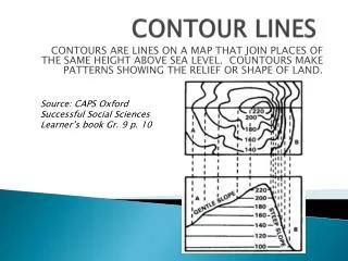
CONTOUR FARMING. How does contour farming reduce the average annual soil erosion rate from a watershed? Why is contour farming not effective in controlling erosion on very steep land? Text, page 107. CONTOUR STRIP CROPPING REDUCES EROSION BY .

E N D
CONTOUR FARMING • How does contour farming reduce the average annual soil erosion rate from a watershed? • Why is contour farming not effective in controlling erosion on very steep land? • Text, page 107 ASAE S268.4
CONTOUR STRIP CROPPING REDUCES EROSION BY • Each year only part of the field is open to the highest erosion rates • Erosion from open strips is trapped in the vegetation on the close-growing strips. ASAE S268.4
FUNCTIONS OF TERRACESFrom ASAE Standard ASAE S268.4 • Reduce Soil Erosion • Retain Soil Moisture For Crop Use • Remove Surface Runoff w/o erosion • Create level land for farmability • Control Sediment Loss from Fields • Reduce Peak Runoff Rates • Improve Water Quality ASAE S268.4
TERRACES FOR EROSION CONTROL • Terraces affect the topographic factor on the USLE (LS). • To be effective for field erosion control terraces need to be spaced at nearly constant vertical intervals. • For Sediment Control terraces need to be level or at a very flat slope, particularly at the lower end. ASAE S268.4
Terrace System Classification • Parallel or Non Parallel • Gradient or Level • Cross-Section • Outlet Type ASAE S268.4
100 95 90 PARALLEL GRADIENT TERRACE SYSTEM ASAE S268.4
100 95 90 PARALLEL LEVEL TERRACE SYSTEM ASAE S268.4
100 95 90 Nonparallel Gradient Terrace System ASAE S268.4
100 95 90 Parallel Gradient Terrace System ASAE S268.4
Broadbase TerraceCross-section ASAE S268.4
Broadbase Terrace • Designed to fit smoothly in the field so that machinery can work the entire area. • Used for erosion control and to retain soil moisture • May be constructed with level or graded channels. • Limited to field slopes <8% ASAE S268.4
Steep-Backslope Terrace Cross Section ASAE S268.4
Steep-Backslope Terrace • Developed for use on field slopes too steep for Broadbase terraces. • Push-up construction reduces overall field slope. • Backslope is a barrier to machine travel. Normally planted to permanent grass. • Less effective for field erosion control ASAE S268.4
Narrow-Base TerraceCross-Section ASAE S268.4
Narrow-Base Terrace • Steep Ridge on both sides planted to grass • Less expensive to construct than broadbase or steep backslope cross-sections. ASAE S268.4
Ridgeless-Channel Terrace Cross-Section ASAE S268.4
Ridgeless-Channel Terrace • Designed for nearly level land • Cut soil spread between terraces • Little interference with field machine operations. • Low cost construction ASAE S268.4
Conservation Bench Terrace Cross-section ASAE S268.4
Conservation Bench Terrace • Moisture Conservation in semi-arid locations with field slopes <5% • Layout includes a watershed area above and the flat channel to catch runoff from the watershed. • Watershed area 2 to 4 times channel area, depending on expected runoff. ASAE S268.4
Bench TerraceCross-section ASAE S268.4
Bench Terrace • Used to create level land for farming, particularly with surface irrigation. • Concept used in ancient mountainside farming systems in Asia and South America. • Used in irrigated areas in the American west. ASAE S268.4
Bench Terraces in Japan ASAE S268.4
Bench Terraces in the US ASAE S268.4
Terrace System Spacing Slope = VI / HI x 100 VI HI ASAE S268.4
VI = Xs+YEq. 7.1, p. 116 in Text • VI is the Vertical Interval between terraces in Feet • s is the Field Slope between terraces in percent • HI = Horizontal Interval or spacing • s = VI / HI * 100 (definition of field slope) • HI = VI / s * 100 ASAE S268.4
VI = Xs+YEq. 7.1, p. 116 in Text • X is a factor that depends on the climate (rainfall) in the area • Related to R in the USLE • See Fig. 7.10, page 117 in the Text • 0.4 < X < 0.8 • Higher value for less rainfall • Use 0.7 for Iowa ASAE S268.4
VI = Xs+YEq. 7.1, p. 116 in Text • Y is a factor that depends on the soil erodibility and cover protection • Related to K and C in the USLE • Lower Value for easily eroded soil with little cover protection • 1 < Y < 4 • Use Y = 2 for average field conditions ASAE S268.4
TERRACE SPACING • Estimate the required terrace spacing for average field conditions on a 5% slope in Northern Arkansas. • From Fig. 7.10: X = 0.5 • For average field conditions: Y = 2 • VI = (0.5)(5)+2 = 2.5+2 = 4.5 ft • HI = (4.5/5)(100) = 90ft. ASAE S268.4
GRADES IN TERRACE CHANNELS Would there be more erosion at the top or bottom of a slope? Why? ASAE S268.4
GRADES IN TERRACE CHANNELS A B C Which of these slopes would have the most erosion, and why? ASAE S268.4
GRADES IN TERRACE CHANNELS • The allowable terrace channel grade is greatest at the upper end of the terrace. • When water removal is a concern, terraces have a minimum grade requirement to prevent ponding • See table 7.2, page 119 in text. ASAE S268.4
MAXIMUM TERRACE LENGTH • The maximum terrace length is based on a maximum drainage area. • Terrace channels should drain no more than 3 acres of watershed • Length x Spacing = Drainage Area ASAE S268.4
100 95 90 Parallel Gradient Terrace System ASAE S268.4
Terrace Channel Water Storage • Runoff Volume = Length x Spacing x Depth of Runoff • Storage Volume = Length x X-section Area • Required X-section for Storage = Spacing x Depth of Runoff • L x S x D = L x A • S x D = A ASAE S268.4
Terrace Channel Water Storage • Terrace Length = 500 ft • Terrace Spacing = 100 ft • Runoff Depth = 0.2 ft • Runoff Volume = 500 x 100 x 0.2 = 10000 ft3 • Storage Volume = 500 x Area • 10000 = 500 x Area • Area = 10000/500 = 20 = 100 x 0.2 ASAE S268.4