Download
1 / 1
10 likes | 103 Views
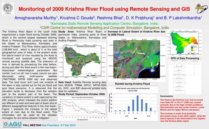
Monitoring of 2009 Krishna River Flood using Remote Sensing and GIS. Amoghavarsha Murthy 1 , Krushna C Gouda 2 , Reshma Bhat 1 , D. K Prabhuraj 1 and B. P Lakshmikantha 1. 1 Karnataka State Remote Sensing Application Centre, Bangalore, India;

E N D
Monitoring of 2009 Krishna River Flood using Remote Sensing and GIS Amoghavarsha Murthy1, Krushna C Gouda2, Reshma Bhat1, D. K Prabhuraj1 and B. P Lakshmikantha1 1Karnataka State Remote Sensing Application Centre, Bangalore, India; 2CSIR Centre for mathematical Modellingand Computer Simulation, Bangalore, India The Krishna River Basin in the south India experienced a major flood during October 2009, which is the second largest eastward draining River in Peninsular India covering vast area in the States of Maharashtra, Karnataka and Andhra Pradesh. This River drains approximately 2,58,948 km2 , which is about 8 % of the total geographical area of India. In the present study the lateral extent of river resulted by the flood is monitored and analyzed using the MODIS remote sensing satellite data. The extension of river is derived by processing the data before, during and after the flood event in the river basin. Associated meteorological parameters like rainfall, river run off, rise in water column are also discussed using multi-source satellite (TMI/TRMM, SRTM DEM etc) and observed data. The land cover and Land use analysis of the basin is also carried out for the pre flood and post flood scenarios. It is observed that the elevation tends to decrease from the western part to the eastern part of the basin. The variations of lateral extent is well captured by the GIS analysis, which indicates the extent pattern are different at east and west part of basin due to different topographical features in the river basin. Figure 1 presents the increase in the lateral extent of river due to the flood event. This information can be used by the disaster managers for pro-active disaster mitigation Study Area: Krishna River Basin in peninsular India, covering parts of three states i.e. Maharashtra, Karnataka and Andhra Pradesh. Data Used: Satellite Remote sensing data from MODIS, TRMM, GPCC, SRTM-DEM etc. GHC and IMD observed gridded daily data for validation. Study Period: September-October 2009 Increase in Lateral Extent of Krishna River due to 2009 Flood DFD of Data Processing Rainfall during Krishna Flood Conclusions: The flood in the Krishna river that occurred from Sept 28th to Oct 4th 2009 was caused primarily due to the high rainfall conditions that prevailed over the Lower Krishna, Lower Bhima and the Upper Bhima sub-basins. The increase in water level gradually decreased closer to the delta region, while the lateral spread of the flood waters was highest near the Krishna delta region. FALL MEETING San Francisco 3-7 Dec 2012