Download
1 / 32
320 likes | 482 Views
Aviation Weather Center: Products & Services Overview Utility of Ensemble Model Guidance. Ed Holicky, Pat Murphy, & David Bright Chicago Aviation Weather Workshop February 25, 2011. Support for the FAA. FAA – Gives NWS requirements for products/services. System Ops. Flight Standards.

E N D
Aviation Weather Center: Products & Services Overview Utility of Ensemble Model Guidance Ed Holicky, Pat Murphy, & David Bright Chicago Aviation Weather Workshop February 25, 2011
Support for the FAA FAA – Gives NWS requirements for products/services System Ops Flight Standards Flight Safety ICAO/WMO WAFS SIGWX Intl. SIGMETs IFFDP No cost to FAA ADDS SIGMET AIRMET Area Forecast Sig Wx Low Winds Aloft TAF “Red Book” Gx No cost to FAA CCFP No cost to FAA CWSU
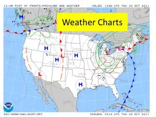
AWC’s Area of Responsibility for Aviation Warnings (SIGMETs)
3 Forecast Desks 24/7 CONUS & Coastal Wtrs Graphic & Text Forecasts AIRMETs 26280 routine issues/yr FA 6570 routine issues/yr SIGMET (non Convective) ~ 500 avg. annual Low-Level Graphic 1456 routine issues/yr SIGMET, AIRMET & Area Forecast BOSZ WA 071545 AIRMET ZULU UPDT 3 FOR ICE AND FRZLVL VALID UNTIL 072100 AIRMET ICE...ME NH VT MA AND CSTL WTRS FROM 70NW PQI YOW TO YSC TO 70NW PQI MOD ICE BTN FRZLVL AND 140. FRZLVL SFC-040. CONDS CONTG BYD 21Z THRU 03Z.
Convective SIGMET • 1 Forecast Desk 24/7 • SIGMET for thunderstorms • “Warning” Product • Associated Hazards:Turbulence, Icing, & Wind Shear • CONUS and coastal waters • Issued Hourly / Valid for 2 hrs • ~ 30,000 issued annually MKCE WST 071855 CONVECTIVE SIGMET 8E VALID UNTIL 2055Z FL AND CSTL WTRS FROM 40NNE CTY-30N OMN-70WSW PIE-170W PIE-40NNE CTY AREA EMBD TS MOV FROM 27020KT. TOPS TO FL350. REF INTL SIGMET CHARLIE SERIES. OUTLOOK VALID 072055-080055 FROM 30N CRG-190ENE OMN-100SW SRQ-100WSW PIE-30N CRG WST ISSUANCES POSS. REFER TO MOST
1 Forecast Desk 20/7 Strategic traffic flow management Collaborators: FAA Meteorologists at CWSUs, Airlines, and AWC Canada ~ 25,000 Forecast Polygons annually Collaborative Convective Forecast Product (CCFP)
Significant Weather Fcsts • 2 Forecast Desk 20/7 • Covers FL250 - FL630 • Global forecast • 24 hour forecast: • Jet Streams • Thunderstorms • Turbulence • Tropopause Heights • Active Volcanoes • Tropical Cyclones • 18,980 routine issuances/yr
Gulf of Mexico & Caribbean • 1 Forecast Desk 24/7 • Oceanic (Atlantic and Pacific) SIGMETs • Weather Forecasts primarily for Helicopter Operations • Clouds • Visibility • Thunderstorms • Rain/Fog • Wind • 4,000 Operating Oil Platforms • 30,000 personnel living on oil platforms • 600 Helicopters • 1.3 Million flights annually
World Area Forecast Center • World Area Forecast System (WAFS) • Formulated by International Civil Aviation Organization and the WMO • Improve the quality and consistency of enroute guidance provided for international aircraft operations • World Area Forecast Centers (WAFC) • WAFC – Washington • AWC provides Significant Weather Forecasts • NCEP Central Operations Provides Wind and Temperature Grids Charts • NWS Telecommunications Gateway supports satellite data broadcasts • WAFC – London • Met Office – Exeter
Operational Automated Products Current Icing Product (CIP) Forecast Icing Probability (FIP) Forecast Icing Severity (FIS) Graphical Turbulence Guidance (GTG)
Aviation Digital Data Service (ADDS) makes available to the aviation community text, digital and graphical forecasts, analyses, and observations of aviation-related weather information • Meets FAA requirements for “Qualified Internet Communications Provider” • Allows operational use by part 121/135 operators (airlines) • Not just a web display • Is a dynamic database • Already has many NEXTGEN data service capabilities • ADDS joint developed • NCAR, GSD, and AWC • Operational Since 2003 • Averaging • 9 million hits per day • 100 GB per day
New Products – Looking Toward NextGen Extended Convective Forecast Product (ECFP) • Valid 18-00Z tomorrow • Depicts 40, 60, 80% probability of thunder • Uses CCFP “look and feel” • Quick look at where tomorrow’s main impact will be
ECFP + SPC + AWC = Consistency Automated based on SREF Prob 26hr in advance Partially automated based on SREF 9hr in advance 6hr CCFP
AWT Science Support • The AWC, with external partners and stakeholders, is increasing internal scientific research for aviation weather via the AWT • Focus on creating tools for forecasters to use within NextGen era • Basic research on NWP data: post-processing, probabilistic, calibration, high resolution, ensembles, convection • Visualization development via AWIPS II and IC4D
Ensemble Guidance at AWC Develop specialized guidance for the specific application (convection and other aviation weather hazards) Design guidance that… Help blend deterministic and ensemble approaches Provide guidance for uncertainty/probabilistic forecasts Provide guidance that aids confidence (i.e., better deterministic forecasts) Illustrates plausible scenarios Allows for diagnostic analysis – not just a statistical black-box
NWS/NCEP Short Range Ensemble Forecast (SREF) EMC SREF system (21 members) 87 hr forecasts four times daily (03, 09, 15, 21 UTC) North American domain Model grid lengths ~32 km Multi-model: ETA (6), RSM (5), WRF-NMM (5), WRF-ARW(5) Multi-analysis: NAM, GFS initial and boundary conds. IC perturbations and physics diversity Recently added bias-correction to some fields Ensembles Available at AWC: SREF
Aviation Impact Guidance for Convective Weather (AIGCW) Historic Traffic SREF TRW Prob FL > 250 FL < 100 All levels
Gridded Flight Composite (20 km)December 2007 to August 2008 – Above 250 KFT Probability (%) aircraft is inside grid box 20 km Grid (AWIPS 215) Data from John Huhn, Mitre
Calibrated SREF Thunder Reliability Frequency [0%, 5%, …] Perfect Forecast No Skill Climatology Calibrated Thunder Probability
Ongoing Activities Future Aviation Ensemble Applications Applications and calibration under development One hourly SREF CCFP guidance (through F036) * Calibration of potential impacts of convection in SREF ^ Rapid Refresh Ensemble Forecast (RREF) – 1hr updates, RUC based * Storm scale (e.g., supercells, squall lines) applications being evaluated *Not discussed today ^Collaborating with John Huhn, Mitre Corp.
Probability Updraft Helicity > 50 m2/s2 Probability of Supercell Thunderstorms F026: Valid 02 UTC 22 Apr 2008 UH > 50 + 25 mi
Observed Radar Radar BREF 0142 UTC 22 Apr 2008
Probability Updraft Helicity > 50 m2/s2 Jack Hales View of the left split looking south from Norman, OK (0145 UTC 22 Apr 2008) (Numerous large hail reports up to 2.25”)
Convective Mode: Linear Detection Determine contiguous areas exceeding 35 dbZ Estimate mean length-to-width ratio of the contiguous area; search for ratios > 5:1 Flag grid point if the length exceeds: 200 miles
Probability Linear Mode Exceeding 200 miles Squall Line Detection F028: Valid 04 UTC 18 Apr 2008 Linear mode + 25 miles
Linear Convective Mode: Impacts Aviation impacts ~ 01 UTC 18 April 2008 Image provided by Jon Racy
Summer 2011 Experiment • Partnership with Department of Defense (AFWA) • 10 member 4km WRF ensemble • Focus on developing tools for identifying aviation impacts • Mid-June to Mid-July • Stationed at the Aviation Weather Testbed • Convective initiation theme • Other models/data: HRRR, CoSPA, LAMP
Summary • AWT is evolving to include more local scientific research in support of AWC mission • Strong partnerships are developing between academic, government, and private industry • Continue broad interaction on convective initiation problems with other Testbeds • Focusing on ensemble guidance for decision support • 2011 Thunderstorm Impact Experiment