Download
1 / 23
230 likes | 238 Views
Understanding warm rain formation using CloudSat and the A-Train. Robert Wood, Terry Kubar , Dennis Hartmann University of Washington. Warm rain – a missing climatology. Image: NASA GSFC. Shipboard remote-sensing shows frequent precipitation from shallow clouds

E N D
Understanding warm rain formation using CloudSat and the A-Train Robert Wood, Terry Kubar, Dennis Hartmann University of Washington
Warm rain – a missing climatology Image: NASA GSFC • Shipboard remote-sensing shows frequent precipitation from shallow clouds • Many echoes below detection limit of current satellite sensors (passive or active) TRMM PR
Warm rain – macrophysicalvs microphysical control • In shallow stratocumulus-topped MBLs (zi < 1500 m) recent studies indicate a dependence of drizzle rate upon cloud droplet concentration (see right) • In deeper trade wind boundary layers no definitive relationship between precipitation rate and microphysics has been observed (e.g. Nuijens et al. 2009) Cloudbase drizzle rate [mm d-1] Cloud droplet conc. Nd [cm-3] R. Wood, J. Atmos. Sci. (2005)
Warm rain – why do we care? • GCMs estimate that: • 1st AIE: -0.5 to -1.9 W m-2 • 2nd AIE: -0.3 to -1.4 W m-2 Lohmann and Feichter (2005) Change in LWP [g m-2] estimated using the GFDL AM2: Ming et al. (2008) Warm rain rate and its sensitivity to aerosols/microphysics is important and unknown
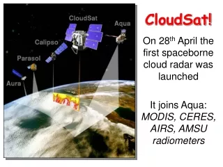
Data/Methods • Collocated CloudSat (GEOPROF) and Aqua-MODIS (MOD06) data: • Daytime data only (13:30 local) • CloudSat cloud top height below freezing level • MODIS cloud top temperature > 0oC • MODIS cloud optical depth > 3 • MODIS used to estimate LWP and Nd: • LWP from standard MODIS cloud product • Nd using method of Bennartz (2007), assuming adiabatic vertical cloud profile • CloudSat used to determine maximum Z in column. Classify > -15 dBZ as precipitating.
Cloud properties associated with different amounts of precipitation SE Pacific As clouds move from non-precipitating to precipitating: (1) LWP and cloud top height show steady increases (2) Microphysical parameters “saturate”
Fraction of clouds that are drizzling (> -15 dBZ) qualitatively consistent with Byers and Hall (1955)
Effective radius not unique determinant of precipitation decreasing LWP
Heuristic model • Goals: • Attempt to reproduce salient features of A-Train data • Minimal physics necessary • Continuous collection model: • Given realistic assumed macro/micro-microphysical cloud structure, allow small fraction of largest cloud droplets at cloud top to fall through cloud collecting droplets (10 liter-1 leads to Z-R consistent with obs.) • Essential inputs are cloud liquid water path (LWP) and cloud droplet concentration (Nd) • Other free parameters constrained by observations
Model cloud structure • Subadiabatic to represent entrainment effects in precipitating trade-cumulus • Adiabaticity parameter fad decreases with height z above cloud base fad =z0/(z0+z) • Adiabaticity height scale z0=500 m (estimated from RICO observations) • Gives liquid water content as a function of height
Precipitation embryos Assumed size distribution (Gamma) Tail of distribution (10 liter-1) constitutes embryonic precipitation drops n(r) r Gamma distribution of cloud drops determined from LWC at cloud top and cloud droplet concentration
Microphysics vs macrophysics Increasing relative importance of LWP over Nd LWP [g m-2]
Rain rate-to-reflectivity (94 GHz) • Several steps need to be taken to compare model with CloudSat: • Use model assumed precipitation DSD to determine radar reflectivity in Rayleigh limit • Mie correction for 94 GHz reflectivity (Bohren-Huffman) • Attenuate model 94 GHz reflectivity using two-way attenuation correction of 8.3 dBZ mm-1 of cloud liquid water (Lhermitte 1990)
CloudSat: colorsModel: lines Reflectivity in [LWP, Nd] space Increasing relative importance of LWP over Ndat high rainrates see also Suzuki and Stephens (2008)
Model vs Obs drizzle fraction and intensity Given [LWP,Nd] joint pdf, model can determine the drizzling fraction and intensity of drizzle in each region
Understanding the model behavior • Precipitation drop embryo formation • depends very strongly upon microphysics (Nd) • Accretion • primarily limited by availability of cloud liquid water (not microphysics) • Clouds in which accretion dominates (thicker clouds, higher LWP) show reduced sensitivity to Nd
Conclusions • Observations and simple heuristic model show decreasing relative importance of microphysics as precipitation rate in warm clouds increases • Broadly consistent with field observations (DYCOMS, ACE-2, EPIC, RICO) • Implications for aerosol-cloud-precipitation interactions
October-November 2008 SE Pacific
VOCALS-CloudSat • VOCALS will yield a unique dataset detailing the properties of clouds, aerosols, and precipitation in the largest stratocumulus sheet on Earth • Development/testing of CloudSat/CALIPSO/A-Train retrievals of light precipitation and MBL microphysical and macrophysical structure • Near-surface issues • technical: surface clutter • physical: evaporation of drizzle
Cloud properties associated with different amounts of precipitation Asian Coast