Download
1 / 38
380 likes | 573 Views
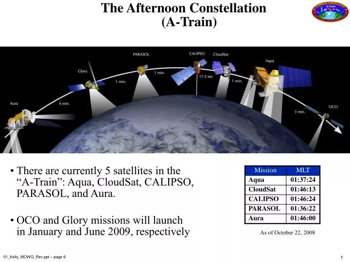
The Afternoon Constellation (A-Train). There are currently 5 satellites in the “A-Train”: Aqua, CloudSat, CALIPSO, PARASOL, and Aura. OCO and Glory missions will launch in January and June 2009, respectively. As of October 22, 2008. 01_Kelly_MOWG_Rev.ppt – page 6.

E N D
The Afternoon Constellation(A-Train) • There are currently 5 satellites in the “A-Train”: Aqua, CloudSat, CALIPSO, PARASOL, and Aura. • OCO and Glory missions will launch in January and June 2009, respectively As of October 22, 2008 01_Kelly_MOWG_Rev.ppt – page 6
Afternoon Constellation Evolution 2002 akelly_trainstatus2.ppt – page 4
Afternoon Constellation Evolution Aura and PARASOL joined in 2004 akelly_trainstatus2.ppt – page 5
Afternoon Constellation Evolution CloudSat and CALIPSO joined in 2006 akelly_trainstatus2.ppt – page 6
Afternoon Constellation Evolution Glory and OCO to be launched in late 2008 akelly_trainstatus2.ppt – page 7
NPP VIIRS - Clouds & Aerosols CrIS/ATMS- Temperature and H2O Sounding OMPS - Ozone The Afternoon Constellation 1:38 PM 1:30 PM 1:15 PM Glory Aura CALIPSO OCO Cloudsat Aqua PARASOL MODIS/ CERES IR Properties of Clouds AIRS Temperature and H2O Sounding OCO - CO2 CALIPSO- Aerosol and cloud heights Cloudsat - cloud droplets PARASOL - aerosol and cloud polarization OMI - Cloud heights OMI & HIRLDS – Aerosols MLS& TES - H2O & temp profiles MLS & HIRDLS – Cirrus clouds pres_frascati_new_missions_gleason.ppt – page 2
Earth Observing Constellations Unique Challenges Terra SAC-C EO-1 Landsat Most constellations are spaced around the Earth to provide instantaneous, global coverage (e.g., GPS, communications, satellite radio, weather). GPS Constellation In contrast, the Earth Science Constellation satellites orbit in close proximity so that observations occur at about the same time over approximately the same region. Due to the relative closeness of the satellites (as small as 10 seconds), safety is an issue. Morning and Afternoon Constellations 55165.ppt – page 11
Earth Observing ConstellationsWhy Fly Constellations? The Earth science community has long advocated placing numerous instruments in space to study the Earth and its environment. • Constellations provide the opportunity to makecoincident, • co-registered, and nearly simultaneous science measurements • from a range of instruments. • The satellites are aligned in their orbital positions so their instrument fields of views overlap. • Earth science data from one satellite’s instrument can be correlated with data from another. The whole is greater than the sum of its parts akelly_trainstatus2.ppt – page 3
6x7 km POLDER 1. 4 km Cloudsat 0.09 km CALIPSO 13.5 km AIRS IR; AMSU & HSB m wave 0.5 km MODIS Band 3-7 5.3 x 8.5 km TES 2.3 km AIRS 0.4-1 m The Afternoon Constellation observational “footprints” vary greatly OCO 1x1.5 km Washington DC USGS Map 55165.ppt – page 10 & A-train3.ppt – page 9
Now for a closer look First up, Aqua … akelly_trainstatus2.ppt – page 6
Purpose Investigates the Earth's water cycle, including evaporation from the oceans, water vapor in the atmosphere, clouds, precipitation, soil moisture, sea ice, land ice, and snow cover on the land and ice. EOS Aqua • Instruments • AIRS: Atmospheric Infrared Sounder – Obtains highly accurate temperature profiles within the atmosphere • AMSU-A: Advanced Microwave Sounding Unit – Obtains temperature profiles in the upper atmosphere (especially the stratosphere) and provides a cloud-filtering capability for tropospheric temperature observations • HSB: Humidity Sounder for Brazil – 4-channel microwave sounder aimed at obtaining humidity profiles throughout the atmosphere. • AMSR-E: Advanced Microwave Scanning Radiometer for EOS – Uses a twelve-channel, six-frequency, microwave radiometer system to measures precipitation rate, cloud water, water vapor, sea surface winds, sea surface temperature, ice, snow, and soil moisture • MODIS: Moderate Resolution Imaging Spectroradiometer – Similar to Terra • CERES: Clouds and the Earth's Radiant Energy System – Similar to Terra akelly_trainstatus2.ppt – page 11
Instrumental Background : MODIS • NASA, Terra & Aqua • launched 1999, 2002 • 705 km polar orbits, descending (10:30 a.m.) & ascending (1:30 p.m.) • Sensor Characteristics • 36 spectral bands ranging from 0.41 to 14.385 µm • cross-track scan mirror with 2330 km swath width • Spatial resolutions: • 250 m (bands 1 - 2) • 500 m (bands 3 - 7) • 1000 m (bands 8 - 36) • 2% reflectance calibration accuracy • onboard solar diffuser & solar diffuser stability monitor AMS2006_Riedi_et_al.ppt – page 3
GEYSER, CA A fast-moving wildfire burned in northern California’s Sonoma wine country on Friday, September 3, 2004. It rapidly grew to several thousand acres, threatening homes and vineyards. Smoke billowed out over the Pacific Ocean for nearly 200 miles. MODIS_FireImages.ppt – page 3
Now for a closer look Next up, Aura … akelly_trainstatus2.ppt – page 6
Purpose Researches the composition, chemistry, and dynamics of the Earth’s atmosphere as well as study the ozone, air quality, and climate. EOS Aura • Instruments • HIRDLS: High Resolution Dynamics Limb Sounder – Observes global distribution of temperature and composition of the upper troposphere, stratosphere, and mesosphere • MLS: Microwave Limb Sounder – Uses microwave emission to measure stratospheric temperature and upper tropospheric constituents • OMI : Ozone Monitoring Instrument – Distinguishes between aerosol types, such as smoke, dust, and sulfates. Measure cloud pressure and coverage, which provide data to derive tropospheric ozone. • TES: Tropospheric Emission Spectrometer – High-resolution infrared-imaging Fourier transform spectrometer that offers a line-width-limited discrimination of essentially all radiatively active molecular species in the Earth's lower atmosphere. akelly_trainstatus2.ppt – page 12
Aura Rephasing (1 of 2) • At the request of the Aura Project Scientist, Aura was moved from its current location (15 minutes behind Aqua) to ~ 8 minutes behind Aqua—completed on May 8, 2008 • Aura is now on a different ground track than Aqua (+18 kilometer (East) offset of Aqua’s WRS-2 path) to enable MLS/CloudSat viewing goal • Aura FOT is maintaining the Control Box to ±10 km (±20 km requirement) A-Train Control Box Configuration 01_Kelly_MOWG_Rev.ppt – page 7
Aura Rephasing (2 of 2) Ground track (WRS Paths) Aqua CloudSat CALIPSO 8 min CloudSat ground track 7 min PARASOL N ~7 min 10 sec Aura Equator MLS Limb track MLS AIRS +/- 825 km MODIS +/- 1150 km OMI +/- 1300 km Orbit Plane MLTAN – 13:35 13:44 Aura MLS now sees the same air mass as CloudSat and CALIPSO 01_Kelly_MOWG_Rev.ppt – page 8
Aura Fuel Usage: (Actual & Predicted) Fall 2004 Delta-i Maneuvers Annual Delta-i Maneuvers Fall 2006 Delta-i Maneuvers Spring 2009 Delta-i Maneuvers Spring 2007 Delta-i Maneuvers 02_Guit_SpacecraftStatus.ppt – page 15
Now for a closer look Next PARASOL … akelly_trainstatus2.ppt – page 6
PARASOL Purpose Studies the role of clouds and aerosols using Polarization and Anisotropy of Reflectances for Atmospheric Science coupled with Observations from a LIDAR. Instrument POLDER: Improve the microphysical and radiative property characterization of clouds and aerosols for model improvement. Source: CNES akelly_trainstatus2.ppt – page 13
Instrumental Background : POLDER • CNES/LOA instrument, Parasol launched 2005 • ~ 705 km polar orbits, ascending (13:30 a.m.) • Sensor Characteristics • 10 spectral bands ranging from 0.443 to 1.020 µm • 3 polarised channels • Wide FOV CCD Camera with 1800 km swath width • +/- 43 degrees cross track • +/- 51degrees along track • Multidirectionnal observations (up to 16 directions) • Spatial resolution : 6x7 km • No onboard calibration system - Inflight vicarious calibration : • 2-3% absolute calibration accuracy • 1% interband – 0.1% interpixel over clouds AMS2006_Riedi_et_al.ppt – page 4
Now for a closer look Next CloudSat and CALIPSO … akelly_trainstatus2.ppt – page 6
Delta II 7420 Launch Vehicle – 10 ft Fairing d314_calipso-cloudsat.pdf – page 7
CALIPSO-CloudSat Coordinated Ascent Overview Orbit Raises 1 Preliminary Burns PARASOL Final Trim Aqua Orbit Raises 2 705 km CloudSat CALIPSO 690 km Cloud-Aerosol Lidar and Infrared Pathfinder Satellite Observations 54809.ppt – page 17
CloudSat Purpose Will advance our understanding of cloud abundance, distribution, structure, and radiative properties. First satellite-based millimeter-wavelength cloud radar 1000 times more sensitive than existing ground weather radars Able to detect the much smaller particles of liquid water and ice (ground-based weather radars use centimeter wavelengths) Instrument Cloud Profiling Radar (CPR) instrument, a 94-GHz nadir-looking radar. Measures the power backscattered by clouds as a function of distance from the radar. Developed jointly by NASA’s Jet Propulsion Laboratory (JPL) and the Canadian Space Agency (CSA). Cloud Profiling Radar akelly_trainstatus2.ppt – page 14
CALIPSO Purpose Determine the distribution of aerosols and thin clouds around the world and will help scientists develop never-before-seen views of Earth’s atmospheric structure and behavior1. Instruments Cloud-Aerosol Lidar with Orthogonal Polarization (CALIOP): Two wavelength polarization-sensitive Lidar that provides high-resolution vertical profiles of aerosols and clouds Wide Field Camera (WFC): Fixed, nadir-viewing imager with a single spectral channel covering the 620-670 nm region Imaging Infrared Radiometer (IIR): Nadir-viewing, non-scanning imager akelly_trainstatus2.ppt – page 15 1 -http://www.nasa.gov/mission_pages/calipso/multimedia/cloud_calip_mm.html
Now for a closer look Final two, OCO and Glory … akelly_trainstatus2.ppt – page 7
Future Missions Two more missions are set to join the A-Train after they launch in late 2008: • The Orbiting Carbon Observatory (OCO) will • Provide space-based observations of atmospheric carbon dioxide (CO2), the principal human-initiated driver of climate change. • The Glory mission will • Collect data on the chemical, microphysical, and optical properties, and spatial and temporal distributions of aerosols, and • Continue collection of total solar irradiance data for the long-term climate record. OCO Glory akelly_trainstatus2.ppt – page 16
The Afternoon Constellation Is an International Undertaking akelly_trainstatus2.ppt – page 9
Principal Investigators/Project Scientists andInternational Partners for Constellation Missions akelly_trainstatus2.ppt – page 10
Morning and Afternoon Constellation Phasing Tracking Station Key: AGS – Alaska Ground Station SGS – Svalbard Ground Station LGS – Landsat Ground Station TDRSW – TDRS-WEST (geo-synchronous) kelly_613_409_final.ppt – page 7
Earth Science Morning Constellation • SAC-C is staying 2 km above Landsat-7 & Terra • EO-1 is currently 15 km below Landsat-7 & Terra • Operating on a 2-year extension through 2009 • Has enough propellant to last through 2011 • • Terra and LandSat-7 are continuing operations at • 705 km. Original Morning Constellation configuration 01_Kelly_MOWG_Rev.ppt – page 20
Debris Avoidance • A number of missions are in a 705 km sun-synchronous polar orbit. • 55 other objects reside in orbits with mean altitudes of 705 +/- 5 km, including, A-Train missions, Terra, EO-1, Landsat-5 and -7, and six Iridium satellites. • More than 1500 cataloged objects pass through this regime each day. • On average, one object comes close • Within 5 km of each constellation mission each day • Within 2 km of each constellation mission once or twice a week. • ESMO has a task with the DOD’s Joint Space Operations Center (JSpOC) to screen all A-Train and Morning Constellation missions to ensure their safety. 01_Kelly_MOWG_Rev.ppt – page 22
Debris Avoidance ManeuversDuring June 2007 – July 2008 • Aura performed a 2-second burn on June 26, 2008 to avoid a piece of well-tracked debris from a U.S. satellite. • CloudSat performed two small maneuvers on July 20 and 22, 2008 to avoid debris from a Delta I LV. • PARASOL performed an early drag make-up maneuver on October 20, 2008 to avoid a space object. • PARASOL is planning a possible avoidance maneuver on October 27 • Terra is evaluating a debris avoidance maneuver this week 01_Kelly_MOWG_Rev.ppt – page 23
INDOCHINA Image captured on March 10, 2006 from the MODIS instrument on the Aqua satellite. Widespread fires throughout Myanmar (Burma), Thailand and Laos.
Afternoon Constellation Control Center Coordination kelly_613_409_final.ppt – page 15