Download
1 / 2
20 likes | 142 Views
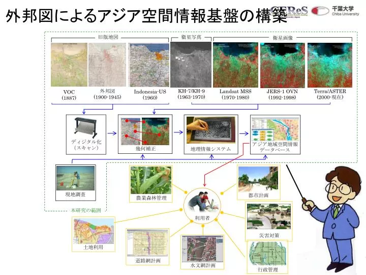
外邦図によるアジア空間情報基盤の構築. 災害対策. 行政管理. 道路網計画. 水文網計画. ディジタル化 (スキャン). 都市計画. 利用者. 土地利用. 旧版地図. 衛星写真. 衛星画像. KH-7/KH-9 (1963-1970). 外邦図 (1900-1945). Terra/ASTER (2000- 現在 ). Landsat MSS (1970-1980). JERS-1 OVN (1992-1998). Indonesia-US (1960). VOC (1887). アジア地域空間情報データベース. 幾何補正.

E N D
外邦図によるアジア空間情報基盤の構築 災害対策 行政管理 道路網計画 水文網計画 ディジタル化 (スキャン) 都市計画 利用者 土地利用 旧版地図 衛星写真 衛星画像 KH-7/KH-9 (1963-1970) 外邦図 (1900-1945) Terra/ASTER (2000-現在) Landsat MSS (1970-1980) JERS-1 OVN (1992-1998) Indonesia-US (1960) VOC (1887) アジア地域空間情報データベース 幾何補正 地理情報システム 現地調査 農業森林管理 本研究の範囲
合成開口レーダによる土壌分類のマッピング N N Sertung island Panjang island Panjang island Sertung island Anak Krakatau island Anak Krakatau island Rakata island Rakata island JERS-1 SAR 19980731 Landsat TM 19920518 断面図