Download
1 / 6
60 likes | 158 Views
Data Sources and Programs. WRF-SI Programs. gridgen_model.exe Purpose: Define the mesoscale simulation domain(s).

E N D
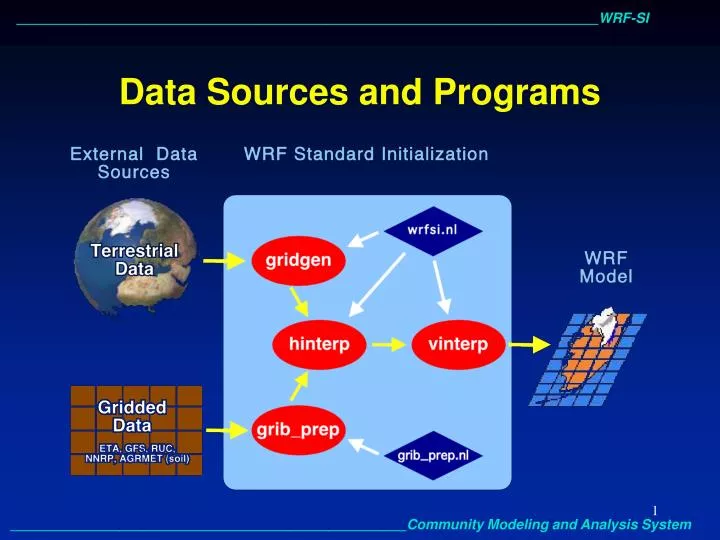
WRF-SI Programs • gridgen_model.exe • Purpose: • Define the mesoscale simulation domain(s). • Read and interpolate static (non-time-varying)terrestrial datasets (terrain, landuse, soil type, deep soil temperature, vegetation fraction, maximum snow albedo, albedo, slope data) from (lat,lon) --> (x,y) projection grid. • The simulation domain is defined in the 'hgridspec' section of the 'wrfsi/data/static/wrfsi.nl' namelist input file. • Automatically run by the ‘window_domain_rt.pl’ perl script . • grib_prep.exe • Purpose: • Read GriB (gridded binary) files - input data from other regional or global NWP models. • Degrib the data to acquire time-varying meteorological data. • Write data out in simple "intermediate" format. • 'Vtables' (files in wrfsi/extdata/static directory) are used to select which variables are used from each model GriB file. You can copy and modify these files for your own GriB data sets.
WRF-SI Programs(continued) • hinterp.exe • Purpose: • Horizontally interpolate meteorological data degribbed by grib_prep.exe onto the simulation domain created by gridgen_model.exe. • Method of horizontal interpolation is controlled by the ‘HINTERP_METHOD’ and ‘LSM_HINTERP_METHOD’ (land masked) variables in the 'interp_control’ section of the 'wrfsi/data/static/wrfsi.nl' namelist input file. Options are nearest neighbor, 4-point bilinear, and 16-point. • vinterp.exe • Purpose: • Vertically interpolate meteorological data from pressure or hybrid levels to WRF's eta-p (terrain following), NMM-h (hybrid), or zeta (old height) vertical coordinate levels. • WRF vertical coordinate levels are defined by the user in the the ‘LEVELS’ array in the 'interp_control’ section of the 'wrfsi/data/static/wrfsi.nl' namelist input file.
WRF-SI Utilities • siscan.exe • Purpose: • A utility program which may be used to read and summarize domain and variable information in hinterp.d* output files. • staticpost.exe • Purpose: • A utility program that converts static.wrfsi.d0X files to WRF I/O API-conforming netCDF files, wrfstatic_d0X. • Automatically run by the ‘window_domain_rt.pl’ perl script. • wrfstatic_d0X files are not used by the WRF model yet; they will be used in the future as a simpler way to run one- and two-way nesting.
WRF-SI Utilities(continued) • plotfmt.exe • A utility program that can be used to make simple graphics from intermediate files. • Plots every field in the intermediate formatted data file. • This utility is not automatically built when WRF-SI is installed. • To compile this program: cdwrfsi/src/grib_prep/util make plotfmt.exe • To run this program: plotfmt.exe intermediate_file_name
WRF-SI wrfsi data bin etc extdata src util graphics gui templates domains extprd work static log training katrina grib_prep.nl gridgen_model.exe grib_prep.exe hinterp.exe vinterp.exe siscan.exe staticpost.exe defaulttraining katrina wrfsi.nl