Download
1 / 30
300 likes | 566 Views
The Ocean Floor. Ch. 23. Studying the ocean floor. Submersibles, satellites, and other technology allow scientists to study the structure and composition of the ocean floor. 1. Echo sounding.

E N D
The Ocean Floor Ch. 23
Studying the ocean floor Submersibles, satellites, and other technology allow scientists to study the structure and composition of the ocean floor.
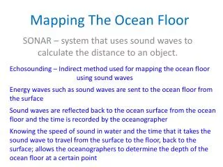
1. Echo sounding • a system that uses transmitted and reflected sound waves to measure distances to the ocean floor; SONAR. • measure how long it takes for signal to be emitted and come back • multi-beam echo sounding measures area twice as wide as ship • use info to make seafloor maps • intensity of sound beams determine seafloor composition • rock & gravel reflect more strongly than mud
2. Sediment Sampling • Core sampling: hollow cylinder removes long cores of material from seafloor • layers are preserved • 1-1500m of sediment are gathered • can analyze past climate, life, and ocean events
3. Satellite observations • greater range & speed for mapping • doesn’t reach floor, bounces off surface • Ocean surface varies based on what’s below • higher over mountains, lower over trenches • determines differences down to cm’s • makes high-resolution seafloor image
HIGH RESOLU-TIONSEAFLOOR IMAGE Pacific and Western Atlantic Oceans
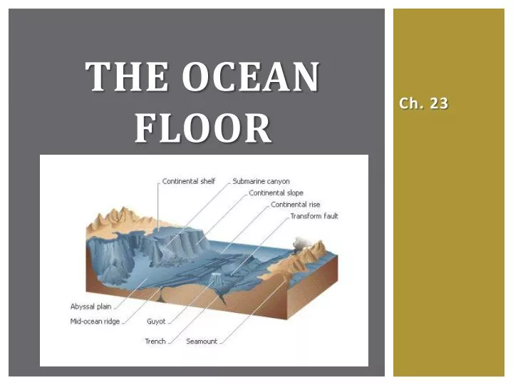
The CONTINENTAL MARGIN In order to understand the continental margin, we must first understand the crust of the Earth. The continental margin is part of the crust.
LAYERS OF THE earth • the Earth has 4 main physical layers:
two types of crust • Continental Crust • lighter, less dense rock • Makes up all continents, but not necessarily all islands • Oceanic Crust • darker, dense rock • any ocean floor or ocean basin
THE MOVING CRUST • all of the crust is divided into ‘pieces’ or plates • (Called lithospheric plates or tectonic plates) • the plates move around on the semi-solid mantle • where the plates meet or connect are called plate boundaries • at plate boundaries, the crust can be moving side by side, apart, or together • different topographic features are created, depending on the type of boundary • topography: the shape of the land
The CONTINENTAL MARGIN The underwater portion of the continental crust. There are two types of continental margins.
1. Active CONTINENTAL margins • continental margins that occur along plate boundaries • plates are moving side by side or together • when one plate sinks under another, a trench is formed • when plates move past each other, a fault is formed • continental rise is small or nonexistent • rocky, short beach w/ cliffs • rugged, coastal mountains on land EX: West coasts of North America and South America
2. Passive continental margins • continental margins that don’t occur along plate boundaries • broad continental shelf • long, sandy beach • no trenches, mountains, or faults EX: East coast of North America
Parts of the continental margin • continental shelf: part of the continent that extends from the shoreline to the continental slope • flat, lengths vary depending on location • continental slope: begins at the shelf edge where depth decreases rapidly to the rise. • 20km long; descends 3.6km • sediment builds up temporarily, then falls • continental rise: descends gradually from the slope to the ocean floor • considered part of ocean basin • very long & gradual
Submarine canyon • an undersea gully that cuts across the continental shelf and slope • rivers erode the continental shelf and deposit sediment on continental slope • gravity and powerful turbidity currents carry sediment down to the continental rise • Very powerful agents of erosion • coarse particles settle first, then fine such as clay
Ocean Basin • Abyssal Plain – flattest of all Earth’s surfaces, composed of sediment from continents • Occur in all oceans • More in Atlantic Ocean where there are fewer trenches • Abyssal hills – small hills, occur in groups next to oceanic ridge systems
Deep-sea trenches • Deep-sea trenches – long, narrow, steep-sided troughs that run parallel to continental margins or to volcanic island chains called island arcs • Exist at subduction zones • Common sites of earthquakes and volcanic activity
Deep-sea trenches • A marginal trench forms if one plate is oceanic and the other is continental. • If the oceanic plate descends below the continental, a line of volcanoes stands on the overriding continental plate, forming mountain chains • If both plates are oceanic, an arc of volcanic islands forms on the overriding plate • Usually in western Pacific
Vents and ridges • Deep ocean vent – geyser that erupts underwater, mixing hot and cold water and bringing up minerals from beneath the surface • Mid-ocean ridges- are undersea mountain ranges, form at divergent plate boundaries where 2 plates are moving apart and magma is rising
Sea mounts & guyots • Seamounts are cone-shaped mountain peaks that rise high above the ocean floor • Occur in all oceans, but more abundant in Pacific Ocean • Volcanic in origin (ex. Hawaiian islands) • Guyots are flat-topped seamounts • Waves removed their tops when they rose above sea level
Coral &coral Atolls • Corals are tiny sea animals that live in shallow, warm waters. Reefs form when new corals grow on top of the dead ones. • A coral atoll is a ring-shaped coral island. It forms when a coral reef develops around a volcanic island. The mountain sinks below the water, leaving a circular reef with a lagoon where the mountain was.
Ocean Floor Sediments • Sediment reaches the ocean floor in several ways: turbidity currents, fall from above, settle from glaciers, remains of microscopic shells • Terrigenous sediments – come from continental rocks an minerals broken down from weathering an erosion • wash into rivers and out to sea • may come from glaciers breaking and dropping into sea
Ocean Floor Sediments • Biogenous sediments come from living sources; they are oozes made mostly of shells and skeletons from tiny marine animals • Calcareous ooze=calcium carbonate • Most common from shells and skeletons • Dissolve as they sink below 4500 meters • Siliceous ooze=silicon dioxide • More common around Equator and Antartica
Ocean Floor Sediments • Hydrogenous sediments form when chemical reactions cause minerals to crystallized from seawater. • Manganese nodules are most common – has manganese, iron oxide, nickel, cobalt, copper… • They form on the sea floor from sediment that falls on them and mixes with the sea water, a few mm every million years • Important to humans but hard to get
Importance of sediments • By studying the layers of sediment in the ocean, scientists can determine: • the extent of former polar ice sheets • the history of water temperatures on sea floor • the pasts behaviors of prevailing winds • pattern of changes in Earth’s climate • The sediments, unique organisms, magnetic records, industrial resources on the ocean floor represent a past look at Earth’s hydrosphere, biosphere, and geosphere.