Download
1 / 17
170 likes | 394 Views
The Ocean Floor. 14.1 The Vast World Ocean. The Ocean Floor. What does the bottom of the ocean look like? If the water of the ocean were drained, what would you see? How much of the Earth is covered with water? Why is Earth called the “Blue Planet”?. The Blue Planet.

E N D
The Ocean Floor 14.1 The Vast World Ocean
The Ocean Floor • What does the bottom of the ocean look like? • If the water of the ocean were drained, what would you see? • How much of the Earth is covered with water? • Why is Earth called the “Blue Planet”?
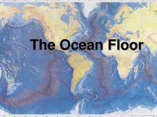
The Blue Planet • 70% of Earth’s surface covered by ocean. Fig 1 Pg 394
The Blue Planet • The world can be divided into four main ocean basins—the Pacific Ocean, the Atlantic Ocean, the Indian Ocean, and the Arctic Ocean. • The Pacific Ocean is the largest and has the greatest depth.
The Vast World Ocean • Bathymetry is the measurement of ocean depths and charting topography of ocean floor 36,000 ft deep Marianas trench
The Challenger • In 1872 HMS Challenger expedition made the first study of Earth’s oceans • 65,000 mile trip took the ship and its crew of scientists to every ocean except the Arctic • How did they measure the depths of the oceans? used line and sinker
The Challenger Recorded depth of the ocean floor
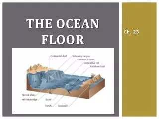
The Topography of the Ocean You could see mountains on bottom of ocean if Earth’s oceans were drained
The Topography of the Ocean E • A Continental slope • B Seamount • C Continental Rise • D Mid Ocean Ridge • E Abyssal Plain • F Continental Shelf • G Ocean Trench
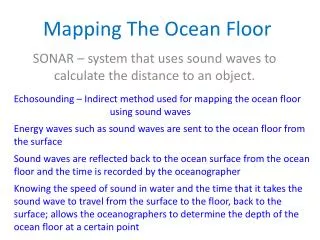
Measuring Topography on the Ocean Floor • Three types of technology allow scientists to study the ocean floor 1. sonar 2. satellites 3. submersibles
Measuring Topography on the Ocean Floor • Sonar • Invented in the 1906 by Lewis Nixon • Sonar is an acronym for Sound Ocean Navigation and Ranging • Also referred to as echo sounding • Sonar works by transmitting sound waves toward the ocean bottom
Measuring Topography on the Ocean Floor Satellites • Satellites are able to measure small differences by bouncing microwaves off the ocean surface • Can measure variations in sea-surface height as small as 3 to 6 centimeters (1 to 2 inches) • Differences in the height of the ocean surface are caused by ocean-floor features
Measuring Topography on the Ocean Floor • Submersibles • Submersibles are small underwater crafts used for deep-sea research • Today, many submersibles are unmanned and operated remotely by computers. These remotely operated vehicles (ROVs) can remain underwater for long periods
Submersibles First submersible was used in 1934 by William Beebe
Submersibles Submersibles can: Record video and photos of previously unknown creatures that live in the abyss Collect water samples and sediment samples for analysis