Download
1 / 25
250 likes | 255 Views
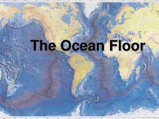
The Ocean Floor. Ch. 19. The Water Planet. global ocean: the body of salt water that covers nearly three-fourths of Earth’s surface The global ocean contains more than 97% of all of the water on Earth. The Oceans: (largest to smallest) The Pacific Ocean is the largest Ocean

E N D
The Ocean Floor Ch. 19
The Water Planet global ocean: the body of salt water that covers nearly three-fourths of Earth’s surface • The global ocean contains more than 97% of all of the water on Earth. • The Oceans: (largest to smallest) • The Pacific Ocean is the largest Ocean • The Atlantic Ocean • The Indian Ocean • TheArctic Ocean is the smallest ocean, and it surrounds the North Pole.
Sea: a large, commonly saline body of water that is smaller than an ocean and that may be partially or completely surrounded by land • Examples of major seas include the Mediterranean, Caribbean, and South China Seas.
Exploration of the Ocean The Birth of Oceanography • Oceanography: the scientific study of the ocean.
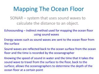
Sonar: sound navigation and ranging, a system that uses acoustic signals and returned echoes to determine the location of objects or to communicate
How sonar is used • Scientists measure the time that the sound waves take to travel from the transmitter, to the ocean floor, and to the receiver in order to calculate the depth of the ocean floor. • Scientists then use this information to make maps and profiles of the ocean floor.
Submersibles: Underwater research vessels, also help oceanographers to study the ocean depths. • Modern submersibles are submarine robots. • These robot submersibles are remotely piloted and allow oceanographers to study the ocean depths for long periods of time.
Not in your notes Underwater Research • Submersibles have helped scientists make exciting discoveries about the deep ocean. • Visual Concept (Sonar)
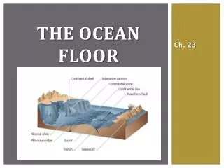
Features of the Ocean Floor The ocean floor can be divided into two major areas. • continental margin: the shallow sea floor that is located between the shoreline and the deep-ocean bottom
2. deep-ocean basin: the part of the ocean floor that is under deep water beyond the continental margin and that is composed of oceanic crust and a thin layer of sediment
I. Continental Margins The line that divides the continental crust from the oceanic crust is not abrupt or distinct.
Shorelines are not the true boundaries between the oceanic crust and the continental crust. • Boundaries are actually some distance offshore and beneath the ocean and the thick sediments of the continental margin.
Continental Shelf ( Beach) • Continents are outlined by a zone of shallow water where the ocean covers the end of the continent. • The part of the continent that is covered by water is called the continental shelf.
Although it is underwater, a continental shelf is part of the continental margin, not the deep-ocean basin. • Changes in sea level affect the continental shelves.
Continental Slope and Continental Rise • At the seaward edge of a continental shelf is a steep slope called a continental slope. • The continental shelf and continental slope may be cut by deep V-shaped valleys. These deep valleys are called submarine canyons.
Other canyons may form over time as very dense currents called turbidity currentscarry large amounts of sediment down the continental slopes. • Turbidity currents form when earthquakes cause underwater landslides or when large sediment loads run down a slope.
These sediments form a wedge at the base of the continental slope called a continental rise.
II. Deep-Ocean Basins • Deep-ocean basins have distinct features. • These features include broad, flat plains; submerged volcanoes; gigantic mountain ranges; and deep trenches. • In the deep-ocean basins, the mountains are higher and the plains are flatter than any features found on the continents are.
Trenches • Trenches: a long, narrow, and steep depression that forms on the ocean floor • as a result of subduction of a tectonic plate • runs parallel to the trend of a chain of volcanic islands or the coastline of a continent, • may be as deep as 11 km below sea level; • also called an ocean trench or a deep-ocean trench • Earthquakes occur near trenches. • Volcanic mountain ranges and volcanic island arcs also form near trenches.
abyssal plain a large, flat, almost level area of the deep-ocean basin • Abyssal plains cover about half of the deep-ocean basins and are the flattest regions on Earth. • Layers of fine sediment cover the abyssal plains.
Mid-Ocean Ridges • The most prominent features of ocean basins are the mid-ocean ridges, which form underwater mountain ranges that run along the floors of all oceans. • Mid-ocean ridges rise above sea level in only a few places, such as in Iceland. • Fault-bound blocks of crust that form parallel to the ridges as the lithosphere cools and contracts are called abyssal hills.
As ridges adjust to changes in the direction of plate motions, they break into segments that are bound by faults. • These faults create areas of rough topography called fracture zones, which run perpendicular across the ridge.
Seamounts: Submerged volcanic mountains that are taller than 1 km • Seamounts form in areas of increased volcanic activity called hot spots. • Seamounts that rise above the ocean surface form oceanic islands. • As tectonic plate movements carry islands away from a hot spot, the islands sink and are eroded by waves to form flat-topped, submerged seamounts called guyotsor tablemounts.