Download
1 / 23
230 likes | 313 Views
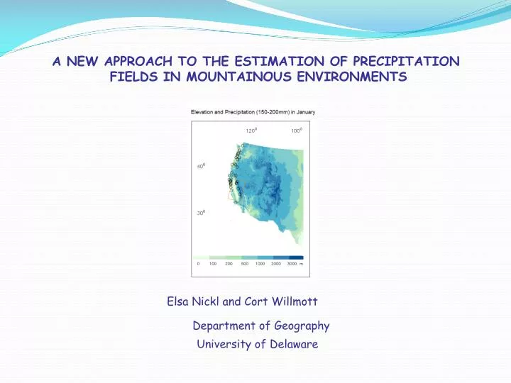
A NEW APPROACH TO THE ESTIMATION OF PRECIPITATION FIELDS IN MOUNTAINOUS ENVIRONMENTS. Elsa Nickl and Cort Willmott. Department of Geography. University of Delaware. HIGH-RESOLUTION DIGITAL ELEVATION INFORMATION. GTOPO30 (USGS) 30 arc sec resolution. EROS Data Center (used by PRISM)

E N D
A NEW APPROACH TO THE ESTIMATION OF PRECIPITATION FIELDS IN MOUNTAINOUS ENVIRONMENTS Elsa Nickl and Cort Willmott Department of Geography University of Delaware
HIGH-RESOLUTION DIGITAL ELEVATION INFORMATION GTOPO30 (USGS) 30 arc sec resolution EROS Data Center (used by PRISM) 3 arcsec resolution Shuttle Radar Topography Mission (USGS) 1 arcsec resolution
METHODS OF PRECIPITATION FIELDS ESTIMATION • Precipitation interpolation methods: • e.g. ordinary kriging, elevational cokriging, etc • Few have been able to adequately explain the complex variability • of precipitation in mountain regions 2. The PRISM model
Principal aspects taken into account in PRISM model: • Relationship between precipitation and elevation: • Precipitation increases with elevation, with a maximum in mountain crests • Relationship between precipitation and elevation can be described by a linear function • 2. Spatial scale of orographic precipitation (orographic elevation) • Mismatch in scale when using actual elevation of stations • “Orographic” elevation estimation in order to avoid this mismatch • The orographic scale depends on the scale of the prevailing storm type • 5 min-DEM appears to approximate the scale of orographic effects explained by available data • 3. Spatial patterns of orographic precipitation (facets) • PRISM divides the mountainous areas into “facets “ • Each “facet” is a contiguous area of constant slope orientation
OBJECTIVES To explore the relationships between the spatial arrangements of orientation, slope, winds and precipitation. To develop a new approach for estimating precipitation fields in mountain regions • DATA • Monthly precipitation National Climatic Data Center (NCDC) (2001-2005) • Digital Elevation information 2.5 minutes (used by PRISM, derived from EROS Data Center 3 arc sec)
ELEVATION, ORIENTATION AND PRECIPITATION GREATER THAN 200 mm DECEMBER, JANUARY, FEBRUARY (seasonal? MAM, JJA, SON?, zoom?) December
December dz/dx dz/dy
January dz/dx dz/dy
February dz/dx dz/dy MAM, JJA, SON?, ZOOMS?
ELEVATION, ORIENTATION, STEEPNESS AND PRECIPITATION (2.5min) DJF (December-February)
ELEVATION, ORIENTATION, STEEPNESS AND PRECIPITATION (2.5min) JJA (June-August)
ELEVATION, ORIENTATION, STEEPNESS AND PRECIPITATION (2.5min) December
ELEVATION, ORIENTATION, STEEPNESS AND PRECIPITATION (2.5min) January
ELEVATION, ORIENTATION, STEEPNESS AND PRECIPITATION (2.5min) February
CELLS TO TAKE INTO ACCOUNT FOR DIFFERENT RESOLUTIONS 5 min (~9.2 km)
CELLS TO TAKE INTO ACCOUNT FOR DIFFERENT RESOLUTIONS 7 min (~12.8 km)
CELLS TO TAKE INTO ACCOUNT FOR DIFFERENT RESOLUTIONS 10 min (~18.3 km)
ELEVATION, ORIENTATION, STEEPNESS AND PRECIPITATION (7.5min) DJF (December-February)
ELEVATION, ORIENTATION, STEEPNESS AND PRECIPITATION (7.5min) JJA (June-August)
ELEVATION, ORIENTATION, STEEPNESS AND PRECIPITATION (12.5min)
CONCLUSIONS • Most largest precipitation events take place in lower-elevation areas (0-500m) with no-orientation (flat terrain) • During DJF period, strong precipitation events in moderate elevation (500-1000m), present a SW orientation tendency. • During JJA period, strong precipitation events are more related to convection. FUTURE RESEARCH • To quantify relationships between precipitation and elevation, steepness and orientation. • To identify relationship between wind and precipitation based on these relationships.