Download
1 / 11
110 likes | 241 Views
HWT Spring Experiment 2011 model comparisons 8-9 June OK-MO severe storms. Storms develop along a dryline Timing is about 22-23z Opportunity to see development of storms Of our models only STMAS available Compared to the HRRR for the 21z forecast cycle.

E N D
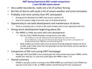
HWT Spring Experiment 2011 model comparisons8-9 June OK-MO severe storms Storms develop along a dryline Timing is about 22-23z Opportunity to see development of storms Of our models only STMAS available Compared to the HRRR for the 21z forecast cycle
8 June 2011: Line of severe storms develops from KS to OK Slight Risk in place Storms begin to develop by 21z then line rapidly develops near and after 00z Opportunity to compare runs beginning at 18z/30 May Storm Prediction Center (SPC) Day 1 Outlook issued at 2000z on 8June SPC severe weather reports for 8 June
8 June 2011 - overview 2100 UTC 8 June – Radar and obs(cold front (blue) & dryline (brown) shown) 0000 UTC 9 June – Radar and observations 0300 UTC 9 June – radar and obs: storms continue along dryline 0300 UTC 9 June – storms diminishing as dryline retreats westward
Forecasts from the 2100 UTC/8 June runs • Only HRRR and STMAS available • Two features present • Dryline in western TX/OK • Very slow moving cold front moving southward across OK/KS • Cells develop along the dryline between 22-23 UTC • Increase some through 0100 UTC, then weaken • Model performance summary: • HRRR a little too quick with development and too aggressive, but overall a • pretty good forecast • STMAS is not a good forecast with really no development along the dryline • And in fact where it does have some storms they really do not occur
2100 UTC 8 June 2011 runs – Analysis comparisons (composite reflectivity) Things are quiet at 2100 UTC. 2100 UTC 8 June– Radar and observations HRRR STMAS
2100 UTC 8 June 2011 runs – 1-h forecast valid 2200 UTC (composite reflectivity) Still nothing at 2200 UTC. 2200 UTC 8 June– Radar and observations HRRR STMAS
2100 UTC 8 June 2011 runs – 2-h forecast valid 2300 UTC (composite reflectivity) Echoes are now developing along the dryline. The HRRR is off somewhat (OK echoes that have not formed yet) but STMAS does not have anything yet except in nw MO. 2300 UTC 8 June– Radar and observations HRRR STMAS
2100 UTC 8 June 2011 runs – 3-h forecast valid 0000 UTC/9 June (composite reflectivity) The same differences are seen that were present at 23z. The HRRR has a nice line of echoes along the dryline, some displaced northward into sw OK, while STMAS still does not have any echoes. 0000 UTC 9 June– Radar and observations HRRR STMAS
2100 UTC 8 June 2011 runs – 4-h forecast valid 0100 UTC/9 June (composite reflectivity) The HRRR is still a little quick/aggressive with new echoes along the dryline, although there are in fact some new echoes in nw OK into KS. STMAS still does not have any echoes, except for something in ne KS into nrn MO, where the HRRR also has cells, but none are observed at this point. 0100 UTC 9 June– Radar and observations HRRR STMAS
2100 UTC 8 June 2011 runs – 5-h forecast valid 0200 UTC/9 June (composite reflectivity) The only development in STMAS seems to be where there are no echoes along the dryline, so not a good forecast. The HRRR is still too aggressive with echoes along the dryline, and in fact now they seem to be starting to weaken in the observations. 0200 UTC 9 June– Radar and observations HRRR STMAS
2100 UTC 8 June 2011 runs – 6-h forecast valid 0300 UTC/9 June (composite reflectivity) Now there is big time weakening of echoes overall as the dryline retreats westward. The HRRR remains too active. STMAS also has too much in sw TX and far southern IA, but never did form cells much along the dryline, so is now better between these two convective areas than the HRRR (but kind of a mixed verification, ends up being better now because of a poor forecast (no storms) earlier in the run). 0300 UTC 9 June– Radar and observations HRRR STMAS