Download
1 / 27
270 likes | 387 Views
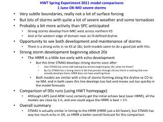
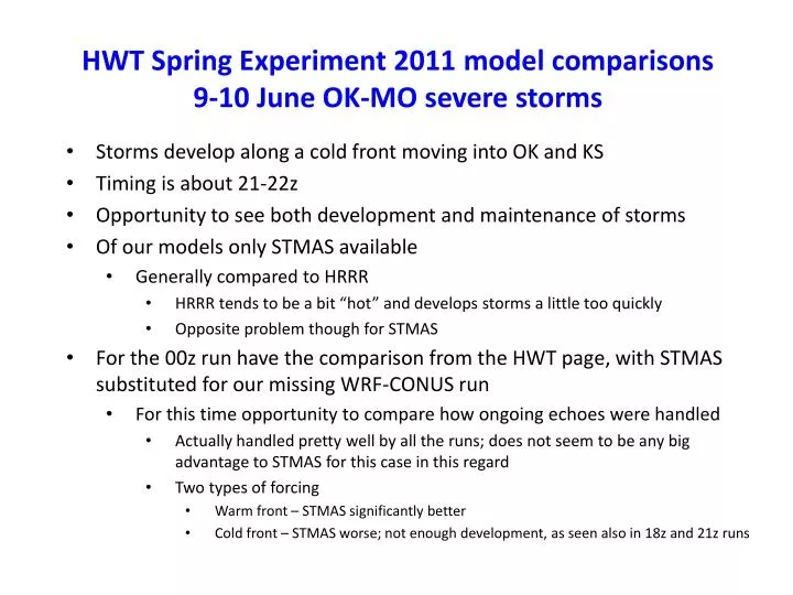
HWT Spring Experiment 2011 model comparisons 9-10 June OK-MO severe storms. Storms develop along a cold front moving into OK and KS Timing is about 21-22z Opportunity to see both development and maintenance of storms Of our models only STMAS available Generally compared to HRRR

E N D
HWT Spring Experiment 2011 model comparisons9-10 June OK-MO severe storms Storms develop along a cold front moving into OK and KS Timing is about 21-22z Opportunity to see both development and maintenance of storms Of our models only STMAS available Generally compared to HRRR HRRR tends to be a bit “hot” and develops storms a little too quickly Opposite problem though for STMAS For the 00z run have the comparison from the HWT page, with STMAS substituted for our missing WRF-CONUS run For this time opportunity to compare how ongoing echoes were handled Actually handled pretty well by all the runs; does not seem to be any big advantage to STMAS for this case in this regard Two types of forcing Warm front – STMAS significantly better Cold front – STMAS worse; not enough development, as seen also in 18z and 21z runs
9 June 2011: Line of severe storms develops from KSto OK Slight Risk in place Storms begin to develop by 21z then line rapidly develops near and after 00z Opportunity to compare runs beginning at 18z/30 May Storm Prediction Center (SPC) Day 1 Outlook issued at 2000z on 9 June SPC severe weather reports for 9 June
9 June 2011 - overview 1800 UTC 8 June– Visible image combined with radar and obs. 2100 UTC 9 June– Visible image combined with radar and obs. 0000 UTC 10 June – radar and obs. 0300 UTC 10 June – radar and obs.
Forecasts from the 1800 UTC/9 June runs • Only HRRR and STMAS available • Two features present • Stationary weak convergence zone central OK to eastern KS • Approaching cold front moving through western OK/KS • A couple of cells start to develop along the cold front by 22 UTC • Then slowly develop through 0000 UTC • Model performance summary: • HRRR a little too quick with development and a bit too much coverage • Plus some development along convergence zone that does not occur • STMAS a little too slow and not quite enough development
1800 UTC 9 June 2011 runs – Analysis comparisons (composite reflectivity) 1800 UTC 9 June – Visible image combined with radar and obs. 1800 UTC 9 June– Radar and obs. Not much happening at 1800 UTC. HRRR STMAS
1800 UTC 9 June 2011 runs – 1-h forecast comparisons valid 1900 UTC (composite reflectivity) 1900 UTC 9 June – Visible image combined with radar and obs. 1900 UTC 9 June– Radar and obs. Only some weak echoes in OK/KS. Main storms are in northern MO, where STMAS is a little too far west and the HRRR is a little too far east. HRRR STMAS
1800 UTC 9 June 2011 runs – 2-h forecast comparisons valid 2000 UTC (composite reflectivity) 2000 UTC 9 June – Visible image combined with radar and obs. 2000 UTC 9 June– Radar and obs. Main storms remain in northeastern MO, where the observed echoes are about between the STMAS and the HRRR. There is also a weak speed convergence/moisture boundary still in central OK to eastern KS, with both models having weak echoes along it as observed, although the HRRR appears to have a stronger cell in northeastern OK. HRRR STMAS
1800 UTC 9 June 2011 runs – 3-h forecast comparisons valid 2100 UTC (composite reflectivity) Clouds starting to develop along front 2100 UTC 9 June – Visible image combined with radar and obs. 2100 UTC 9 June– Radar and obs. There are 2 areas of interest: 1) the approaching cold front (arrows in figure above) where some clouds but no echoes are found, and 2) the convergence line farther east, where the HRRR is trying to develop cells from ne OK to western MO. HRRR STMAS
1800 UTC 9 June 2011 runs – 4-h forecast comparisons valid 2200 UTC (composite reflectivity) Clouds building along front 2200 UTC 9 June – Visible image combined with radar and obs. 2200 UTC 9 June– Radar and obs. In terms of the 2 areas of interest: 1) along the approaching cold front (arrows) clouds are growing with a couple of echoes starting to develop, and 2) the convergence line farther east, where pretty much even the weak echoes are gone in the observations. The HRRR is too quick to develop cells along the cold front and has some farther east. At this time the quieter STMAS is better. HRRR STMAS
1800 UTC 9 June 2011 runs – 5-h forecast comparisons valid 2300 UTC (composite reflectivity) Clouds and a couple of echoes building along front 2300 UTC 9 June – Visible image combined with radar and obs. 2300 UTC 9 June– Radar and obs. Basically the HRRR has too much development at this point along the cold front, where there are really only 2 cells of note. STMAS has a single cell in north-central KS, so not enough going on, and it is not located correctly. Other area of continued development is across northern MO, where the HRRR seems to have a better forecast. HRRR STMAS
1800 UTC 9 June 2011 runs – 6-h forecast comparisons valid 0000 UTC (composite reflectivity) Clouds and echoes slowly building along front 0000 UTC 10 June – Visible image combined with radar and obs. 0000 UTC 10 June– Radar and obs. Similar to 23z, the HRRR has a bit too much development along the cold front while STMAS does not have quite enough. The HRRR cell in sw MO, along the old line of weak echoes noted earlier, is not found in the observations. HRRR STMAS
Forecasts from the 2100 UTC/9 June runs • Only HRRR and STMAS available • Two features present • Stationary weak convergence zone central OK to eastern KS • Approaching cold front moving through western OK/KS • A couple of cells start to develop along the cold front by 22 UTC • Then slowly develop through 0000 UTC • Model performance summary: • HRRR a little too quick with development and a bit too much coverage • Plus some development along convergence zone that does not occur • STMAS a little too slow and not quite enough development
2100 UTC 9 June 2011 runs – analysis comparisons valid 2100 UTC (composite reflectivity) Clouds starting to develop along front 2100 UTC 9 June – Visible image combined with radar and obs. 2100 UTC 9 June– Radar and obs. Both models appear to start out in pretty good shape with the main echoes in LA and MO. HRRR STMAS
2100 UTC 9 June 2011 runs – 1-h forecast comparisons valid 2200 UTC (composite reflectivity) Clouds building along front 2200 UTC 9 June – Visible image combined with radar and obs. 2200 UTC 9 June– Radar and obs. Echoes are forming too quickly in KS in the HRRR. Both have a good cell in far northeastern MO, although could argue that the STMAS is a little better here. HRRR STMAS
2100 UTC 9 June 2011 runs – 2-h forecast comparisons valid 2300 UTC (composite reflectivity) Clouds and a couple of echoes building along front 2300 UTC 9 June – Visible image combined with radar and obs. 2300 UTC 9 June– Radar and obs. Similar to the 1800 UTC forecasts, the HRRR has a little too much too soon, while just the opposite (in fact NO development yet) in the STMAS forecast, along the cold front. HRRR STMAS
2100 UTC 9 June 2011 runs – 3-h forecast comparisons valid 0000 UTC (composite reflectivity) Clouds and echoes slowly building along front 0000 UTC 10 June – Visible image combined with radar and obs. 0000 UTC 10 June– Radar and obs. Similar to 23z, except still hardly anything at all in the STMAS run along the cold front, while too much near and just east of Kansas City. HRRR looks pretty good along the cold front central KS to OK, but is off in placement of storms in extreme northeastern KS to northern MO. HRRR STMAS
2100 UTC 9 June 2011 runs – 4-h forecast comparisons valid 0100 UTC (composite reflectivity) Pretty similar to what we have seen over the last couple of hours since 23z or so, with STMAS not having enough development along the cold front. The HRRR looks pretty good along the cold front central KS to OK after having too much development earlier. Both models are off in the placement of storms from northeastern KS and across northern MO. Echoes continue along cold front 0100 UTC 10 June– Radar and obs. HRRR STMAS
2100 UTC 9 June 2011 runs – 5-h forecast comparisons valid 0200 UTC (composite reflectivity) Remains similar to what we have seen over the last couple of hours since 23z or so, with STMAS not having enough development along the cold front, while the HRRR has more and is closer to what is observed. Both models have the strongest echoes to the north, from ne KS eastward across northern MO, both being somewhat off from what is observed. Echoes developing more along cold front 0200 UTC 10 June– Radar and obs. HRRR STMAS
2100 UTC 9 June 2011 runs – 6-h forecast comparisons valid 0300 UTC (composite reflectivity) Now the verification is somewhere between the underforecast from STMAS and the now more overforecast from the HRRR. Both are off somewhat in MO (and STMAS in northeastern KS). Echoes still found along cold front 0300 UTC 10 June– Radar and obs. HRRR STMAS
Forecasts from the 0000 UTC/10 June runs • Used the HWT page for this comparison and added in STMAS • CONUS WRF run was not available for this date • Two features present • Warm front quasi-stationary boundary (labelled “A” in the SPC analysis below) in northern MO • Approaching cold front moving through OK/KS (labelled“B” below) • Some evaluation • All the models do a decent job at 0-h, and at 1-h all but ARW-cycled are good • STMAS quite a bit better >1-h with cells near warm front in northern MO • But STMAS really lacking along the cold front A SPC 0300 UTC analysis B
Analyses at 0000 UTC on 10 June. Note that the focus area is shifted a bit to the northeast from earlier times shown, so the STMAS forecast overlaps only some of this area. STMAS All the models pick up the strong cell in KS and the storms across northern MO in the initial analyses.
0000 UTC/10 June runs: 1-h forecasts valid 0100 UTC. STMAS There are now variations in the storms across northern MO, with STMAS doing a good job in keeping strong cells. The other point of interest is the backbuilding of the cell complex in south-central KS, which may be seen more in STMAS.
0000 UTC/10 June runs: 2-h forecasts valid 0200 UTC. STMAS STMAS continues to do the best with the cells in northern MO. However, it is becoming too weak with the storms along the cold front in KS.
0000 UTC/10 June runs: 3-h forecasts valid 0300 UTC. STMAS Although STMAS remains the best with the cells in northern MO, it totally misses the storms along the cold front in se KS.
0000 UTC/10 June runs: 4-h forecasts valid 0400 UTC. STMAS As before, STMAS quite good with the cells in northern MO, but poor with the storms along the cold front in se KS.
0000 UTC/10 June runs: 5-h forecasts valid 0500 UTC. STMAS STMAS has a nice arc of echoes now in northerneastern MO, where other models miss the storms. Echoes along the cold front in se KS are beginning to weaken; still not in STMAS.
0000 UTC/10 June runs: 6-h forecasts valid 0600 UTC. STMAS Note some new development in far northern OK. This is missed by STMAS, with something perhaps in the HRRR and ARW/Thomp/MYJ runs.