Download
1 / 20
270 likes | 799 Views
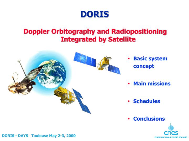
DORIS. Doppler Orbitography and Radiopositioning Integrated by Satellite. Basic system concept Main missions Schedules Conclusions. DORIS system Overview. Satellite with DORIS instrument. B.O.T. : Time reference and Orbitography Beacon. B.M. : Master Beacon (B.O. +

E N D
DORIS Doppler Orbitography and Radiopositioning Integrated by Satellite • Basic system concept • Main missions • Schedules • Conclusions DORIS - DAYS Toulouse May 2-3, 2000
DORISsystem Overview Satellite with DORIS instrument B.O.T. : Time reference and Orbitography Beacon B.M. : Master Beacon (B.O.+ System timeand frequency references +Instruments control& mission uploading) B.O. : Orbitography Beaconof the permanent system network(Quartz USOPrecisely positionned meteo data and beacon status transmission) DORIS Mission and System Center B.C. : Customer Beacon to be positionned(idem B.O.can be field packaged) Users Beacons NETWORK DORIS GROUND SEGMENT DORIS - DAYS Toulouse May 2-3, 2000
DORIS Space segment DORIS/SPOT 2 1990 DORIS/TOPEX 1992 DORIS/SPOT 3 1993 DORIS/SPOT 4 1998 DORIS/ENVISAT Mid 2000DORIS/JASON End 2000 DORIS/SPOT 5 2001 DORIS - DAYS Toulouse May 2-3, 2000
DORIS DORIS - DAYS Toulouse May 2-3, 2000
DORIS Main missions • Precise orbit determination for Topex/Poseidon and Jason: • Altitude of Topex/Poseidon accurate to within three centimetres, on radial component in support to scientific (altimetry) mission performance • Jason to provide centimetre accuracy • Accurate location of ground beacons • to establish and maintain the terrestrial reference systemused for altimetry measurements • for geodetic and geodynamics applications • Accurate autonomous navigation capability • Models improvements: • gravity field, air drag, ionosphere, troposphere. DORIS - DAYS Toulouse May 2-3, 2000
DORIS Main missions Orbit determination (1/2) • Doris was originally designed for precise orbit determination in support of altimetry satellite missions: • within 5 cm for Spot 2 • 3 cm for Topex radial component • Objective of 1 cm for Jason, thanks to improved gravitational models and cross utilization of other geodetic technics (GPS, Laser, …). DORIS - DAYS Toulouse May 2-3, 2000
DORIS Main missions Orbit determination (2/2) • Real time navigation: • Thanks to on-board measurement processing by DIODE software (included in Doris software), and demonstrated in Spot 4, • Less than 30 cm rms 3 axes achievable on Jason, • Time synchronisation: 3 micro seconds wrt TAI or UTC time scale. • Location station calibration (radar, 2 GHz networks) • Precise estimation of altitude control thruster efficiency (Spot) DORIS - DAYS Toulouse May 2-3, 2000
DORIS orbit determination products Accuracy Turnaround Application Satellite operation • Processing of satellite • altimetry measurements • Calculation of manœuvre efficiency • Calibration of other • measurement systems • (radar, 2GHz location, etc.) Delayed time (ground) Initial orbit 10 centimetres 48 hours Precise orbit 3 centimetres 1 month Real time (onboard) • Satellite autonomy • Auxiliary data for • satellite payload Onboard real time Precise Doris (Jason) Single-frequency Doris (navigation) <1 metre 10 metres Immediate DORIS PERFORMANCEOrbit determination mission DORIS - DAYS Toulouse May 2-3, 2000
DORIS Main missions Location • Geodesy accurate absolute and relative location • Geodynamics plate tectonics • Volcanology surface deformation monitoring • Glacier monitoring • Landslide monitoring • Construction and monitoring of large civil engineering structures DORIS - DAYS Toulouse May 2-3, 2000
DORIS Geodetic applications (1/2) • Precise point positionning • Doris provides fast data on ground beacons positions; • The CLS company provides Doris services on an operational, commercial basis: • precise point coordinates at remote locations: islands, platforms, secondary reference points, etc. • tying local geodetic networks into reference networks, • long-term measurement of geodynamic drifts, • remote monitoring of natural hazard areas(e.g., seismic zones, volcanoes, landslides). DORIS - DAYS Toulouse May 2-3, 2000
DORIS Geodetic applications(2/2) • Earth Rotation • Doris provides Earth rotation parameters with a one-day resolution, used to study of dynamic interactions between fluid and solid Earth components. • Earth Center position Source IERS DORIS DORIS - DAYS Toulouse May 2-3, 2000
DORIS Reference systems • Doris was accepted in 1994 as a new technique of the International Earth Rotation Service. • IERS objectives include the establishment and maintenance of a high accuracy Earth reference system. • Doris contributed to ITRF 94, 96, 97 and will contribute to ITRF 2000. • Because of its performances, the international community proposed to create an International Doris Service at the last general assembly of the IGGU (July 1999). DORIS - DAYS Toulouse May 2-3, 2000
DORIS Geophysics • Doris can be used to measure tectonic plates relative motions of the terrestrial lithosphere; • Measurement accuracy allows validation of cinematic models and determination of local phenomena. DORIS - DAYS Toulouse May 2-3, 2000
DORIS DORIS - DAYS Toulouse May 2-3, 2000
DORIS PERFORMANCE Ground beacon location 1- Results within 2 or 3 days Operational geodesy (1 m to 15 cm over 1 day) 20 cm 2- Results within 1 week 3- Results within a few months High precision geodesy (10 to 0.1 cm over 1 year)Altimeter reference 10 cm 0 cm 1 2 5 10 30 Measurements, In days DORIS - DAYS Toulouse May 2-3, 2000
DORIS Other DORIS applications • Improvement of the Earth gravity field; • Global ionosphere mapping for radio-electric signal propagation error correction; • Calibration and validation of other space geodesy techniques. DORIS - DAYS Toulouse May 2-3, 2000
Pleïade DORISGeneral schedule 90 91 92 93 94 95 96 97 98 99 2000 01 02 03 04 Spot 2 Topex-Poséidon Spot 3 Spot 4 Envisat 1 Jason 1 Spot 5 Earth rotation Accurate location Navigation Gravity field Precise orbit DORIS - DAYS Toulouse May 2-3, 2000
1st generation, Spot 2, 3 and 4, Topex/Poseidon No redundancy 2nd generation, Envisat No redundancy 2nd miniaturized generation, Jason, Spot 5 No redundancy miniaturized generation Mass produced 0 Data 1990 1980 2000 DORIS Instrument evolution Mass 20 kg 10 kg DORIS - DAYS Toulouse May 2-3, 2000
DORIS PERFORMANCE Ground location beacon evolution Mass 1st generation, 50 GLBs produced 20 kg 2nd generation 25 GLBs produced 10 kg 3rd generation, enhanced performance, 0 Date 1980 2000 1990 DORIS - DAYS Toulouse May 2-3, 2000
Conclusions • The Doris accurate location system provides outstanding performance. • It has been constantly improved since it became operational in the early 90’s and additional improvements are already planned for the next ten years. • It will continue to complement existing GPS, VLBI and SLR systems and at the same time it will provide unique capabilities such as: • a worldwide ground network, • precise measurements of vertical crustal movements (better than 1 mm/year) • presice measurement of temporal variations of geodetic parameters (geocenter movement). DORIS - DAYS Toulouse May 2-3, 2000