Download

1 / 7
80 likes | 111 Views
Types of Maps. Maps are amazingly useful tools. You can display information, data or make connections of seemingly unrelated things. Maps that show a wide range of general information about an area are called general purpose maps

E N D
Types of Maps • Maps are amazingly useful tools. You can display information, data or make connections of seemingly unrelated things. • Maps that show a wide range of general information about an area are called general purpose maps • There are two types of general purpose maps: political and physical
Political Maps • Political Maps show the names and boundaries of countries or states and often identify only major physical features.
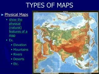
Physical Maps • Physical Maps identify specific landforms and water features.
Physical Maps Cont. • Colors and shading may be added to a physical map to show relief-orhow flat or rugged the land surface is. • In addition physical maps may use colors to show elevation-theheight of an area above sea level.
Physical Maps Cont. • One kind of physical relief map that shows elevation is called a contour map. • A contour map has contourlines-one linefor each major level of elevation. All of the land at an elevation is connected by a line. These lines usually form ovals or circles, one inside of another. • If the lines are far apart the surface is generally flat, if the line are close together, the land is generally rugged or steep Steep Flat
Special Purpose/Thematic Maps • Some maps are made to present specific kinds of information • Special purpose maps may present climate, natural resources, population density, or historical information.
Tools for Reading Maps • Map Key/Legend-explains the symbols, and colors used on a map. • Scale bar- a measuring bar that helps you determine distance on a map.