Download
1 / 23
230 likes | 375 Views
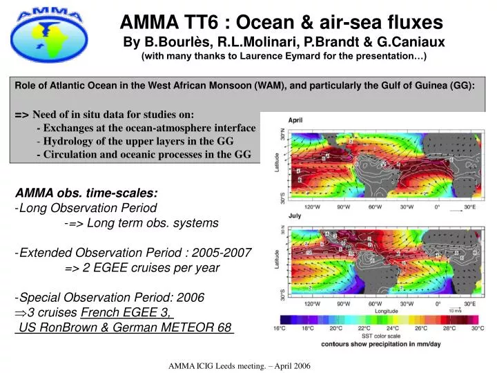
AMMA TT6 : Ocean & air-sea fluxes By B.Bourlès, R.L.Molinari, P.Brandt & G.Caniaux (with many thanks to Laurence Eymard for the presentation…). Role of Atlantic Ocean in the West African Monsoon (WAM), and particularly the Gulf of Guinea (GG): => Need of in situ data for studies on:

E N D
AMMA TT6 : Ocean & air-sea fluxes By B.Bourlès, R.L.Molinari, P.Brandt & G.Caniaux (with many thanks to Laurence Eymard for the presentation…) Role of Atlantic Ocean in the West African Monsoon (WAM), and particularly the Gulf of Guinea (GG): => Need of in situ data for studies on: - Exchanges at the ocean-atmosphere interface - Hydrology of the upper layers in the GG - Circulation and oceanic processes in the GG • AMMA obs. time-scales: • Long Observation Period • => Long term obs. systems • Extended Observation Period : 2005-2007 • => 2 EGEE cruises per year • Special Observation Period: 2006 • 3 cruises French EGEE 3, US RonBrown & German METEOR 68 AMMA ICIG Leeds meeting. – April 2006
EOP: 1) French EGEE cruises carried out in 2005 Egée 1 trackline (June-July 2005) Egée 2 trackline (September 2005) Repeated sections at 10°W, 3°E: AMMA ICIG Leeds meeting. – April 2006
EOP: 1) French EGEE cruises carried out in 2005 WORKS done during EGEE 1 & EGEE 2 cruises: - About 60 hydrological profiles (CTD-O2) and current profiles (L-ADCP) per cruise, along with 11 sea water samplings along the water column (surface to 500m or 1000m) for salinity, dissolved oxygen and nutrients analysis ; - continuous measurements of upper layer current & sea surface temperature and salinity; - More than 110 temperature profiles per cruise (XBT); - Change of the 4 PIRATA ATLAS buoys ; - 24 ARGO profilers (18 french PROVOR and 6 US SOLO) deployment; - 16 surface drifters (SVP) deployment; - 30 sea surface samplings per cruise for salinity, nutrients, CO2 , C13 and O18 ; - 12 microstructure profiles along 10°W during EGEE 2 (coll. IFM-GEOMAR); - 60 sea water sampling 10°W and 3°E during EGEE 2 for Helium (coll. Univ.Bremen) AMMA ICIG Leeds meeting. – April 2006
EOP: 2) Other French EGEE operations carried out in 2005 • The meteorological station of Sao Tome worked continuously. • The daily average data are get at a 1h period (transmitted via Argos), • and high frequency got after each servicing operation. • These data are unfortunately not provided through the GTS • (the problem is out of our competence, as due to WMO rules!). • One autonomeous thermometer has been installed at the port of Cotonou (Benin).A second one has been installed close to the Sao Tome meteorological station. • The daily average data are get at a 1h period and got after each servicing operation. First data are at now available at IRD Center of Bretagne, and these ones along with the ones of the EGEE cruises, should be got directly accessible through internet in a close future (but available on demand). • (Note; Other thermometers should be installed in the next months in Togo, Ghana, Ivory Coast. As decided during the 1st international AMMA conference in Dakar (Dec.2005), cooperation for regional data gathering is planed (and on the way) between different concerned countries (Nigeria, Benin, Togo, Ghana, Ivory Coast, Senegal)). • A document about available regional ocean data is in preparation with all African partners… AMMA ICIG Leeds meeting. – April 2006
Quasi-simulteneous cruises (May-July 2006) during the 2006 AMMA SOP : Senegal CRODT-UCAD-IRD cruises potentially possible only after SOP… US NOAA Cruise German IFM-Geomar Cruise French IRD-MétéoFrance Cruise AMMA ICIG Leeds meeting. – April 2006
1: EGEE 3 cruise: Schedule & trackline Leg 1: May 24 – June 16/17 Leg 2: June 19 – July 6 AMMA ICIG Leeds meeting. – April 2006
1: EGEE 3 cruise: Measurements & Operations • 1. Hydrology and currents: • - About 100 CTD-O2 & LADCP current velocity profiles (from the surface down to 1000m or 2000m • within the equatorial band, every ½° along the 10°W, 2°50’E, 6°E and 6°S sections). • - Ocean microstructure measurements (vertical mixing) (coll. IFM-GEOMAR/Germany). • - Sea water samplings (salinity, dissolved oxygen, nutrients, Helium, and for a few stations at depths CO2, O18, C13 and CFCs, along with for biogeochemical analysis). • - Continious upper layer currents, sea surface temperature and salinity. • - Deployement of: • - 14 Surface Velocity Profilers (SVP) • - 12 ARGO profilers will also be deployed. • - 120 XBT profiles. • - 12 thermistance drifting chains (“Marisonde”) • 2. Flux measurements: • - Turbulent fluxes will be estimated by different methods (inertial dissipation, correlation and bulk). • - Radiation, solar and infrared, precipitation and precipitation temperature. • - Skin sea surface temperature + solar radiation and aerosol (coll. RSMAS/USA). • - Turbulent fluxes during 6 long duration stations (24h to 48h) • - Radio-soundings (twice a day, with realtime data transmission by GTS). AMMA ICIG Leeds meeting. – April 2006
1: EGEE 3 cruise: Measurements & Operations 3. Simultaneous airplane measurements: - Two aircrafts will survey twice the 2°50’E meridional section (“Benin” section) from the African coast to 2°N, at low and high atmosphere levels. The research vessel will be at the same date at some location of this section, 4. Other operations: - 4 ATLAS meteo-oceanic buoys of the PIRATA array will be replaced at 0°E-0N, 10°W-10°S, 10°W-6°S, 10°W-0°N. - 1 additional PIRATA ATLAS buoy will be deployed at 6°S-8°E ( PIRATA-Southeast extension). - Intervention at the meteorological station of Sao Tome in October 2003 before a long duration station (24-48h). AMMA ICIG Leeds meeting. – April 2006
2006 1: EGEE 3 cruise:Timing constraints (1): Priority: Servicing of the PIRATA ATLAS buoys in order they properly work (and be there…) at the very beginning of the WAM onset and SOP experiment => 1st leg in the western part of the GG • At now: • Buoy at 10°W-0°N drifts off Ghana from Feb.3… • No news from the buoy at 6°S-0°N from Sept.15… AMMA ICIG Leeds meeting. – April 2006
Pre-onset Saharan Heat Low Tamanrasset 23°N Bouressa 20°N ITF Gao 16.5°N GOURMA CATCH Niamey 13.5°N Ouaga Parakou 9.5°N Djougou Cotonou 6.3°N ITCZ FR-ATR FR-F20 1: EGEE 3 cruise:Timing constraints (2): 2 aircrafts surveys during SOP 1 simultaneous to the cruise along the 2°50’E section in Mid-June & early July (ie before and after the ITCZ « jump ») => June 15 & July 4 at 2°50’E High atmosphere Low atmosphere AMMA ICIG Leeds meeting. – April 2006
1: EGEE 3 cruise:Timing constraints (3): Priority:Air-sea fluxes experiment and measurements => 6 long duration stations (36h->48h) at: - the PIRATA Atlas buoy positions, ie 0°E-0°N, 10°W-10°W, 10°W-6°S, 10°W-0°N, and 8°E-6°S. - São Tomé Island, off the meteorological station AMMA ICIG Leeds meeting. – April 2006
1: EGEE 3 cruise: Detailed planed timing: Leg 1 ; Leg 2 Dpt 1: May26 Dpt 2: June 19 6°E: June 20 2’50E: June 15-16 0-10: June 9-11: 48h Sao Tome: June 21-23: 48h 8E: June 25 0-0: May27-29: 48h 6S: June 26 6-10: June 5-7: 48h 2°50’E: June 30 – July 5 8E-6S: June 27-29: 48h 10-10: June 1-3: 48h AMMA ICIG Leeds meeting. – April 2006
1: EGEE 3 cruise: Profilers deployements • Position of ARGO profilers (12) and SVP (12) deployments • exact positions will be decided at the last moment according to the ARGO profilers • and drifters still in the area, and in agreement with ARGO configuration b) Position of « MARISONDE » (12) deployments Goal: they stay in the area all along the SOP 1st leg =9 : 5 between 0-0 and 10s-10w 4 around 1°N,between 10w & 3E 2nd leg = 3 : along 2°50’E Marisondes: - hourly measurements - data transmission every 1h30’ - autonomy: about 6 months AMMA ICIG Leeds meeting. – April 2006
1: EGEE 3 cruise: Instruments installation Fluxes: (1) Foredeck boom (Net radiation sensors) (2) Instrumented mast (classical met. parameters and turbulence sensors) (3) Central mast (Downward Long and shortwave radiation sensors) (4) Ceilometer (4500 m) (5) Radiosounding post Ocean turbulence (MSS, IFM): On the back desk, « babord » + MAERI (RSMAS) AMMA ICIG Leeds meeting. – April 2006
2: RON BROWN cruise: 23 May - 16 July 2006 PIs: B. Molinari, R. Lumpkin and C. Schmid NOAA/Atlantic Oceanographic and Meteorological Laboratory • Cruise goals: • Deploy 2 ATLAS moorings • (at 23°W-4°N & 23°W-11°30’N) • Service PIRATA mooring • (at 23°W-0°N) • Conduct CTD, shipboard ADCP survey down 23°W • Deploy drifters, floats, radiosondes, ozone sondes • Observe Saharan Air Layer events (opportunistically) AMMA ICIG Leeds meeting. – April 2006
2: RON BROWN cruise: 23 May - 16 July 2006 PIs: B. Molinari, R. Lumpkin and C. Schmid NOAA/Atlantic Oceanographic and Meteorological Laboratory • along the 23°W longitude (meridional section carried out • twice at the few weeks interval). • 1) Hydrology and currents: • on-station CTD and current profiling from the surface down • to 1500m depth will be carried out (about 60 CTD profiles • during each leg). • - Sea water samplings ( salinity and oxygen). • - About 100 temperature profiles with XBT. • 2) Atmospheric measurements: • Atmospheric data will be collected to characterize the • vertical structure of the Saharan air layer, including • mineral dust aerosol over the Atlantic Ocean. • - Skin sea surface temperature, • all along the cruise: • - solar radiation and aerosol measurements will be carried out • - Radiosounding (twice a day, transmitted in real time) • - Shipboard current measurements and sea surface • temperature and salinity will be continuously measured; AMMA ICIG Leeds meeting. – April 2006
2006 PIRATA NEE (2007) PIRATA array 2005 PIRATA SWE 2006 PIRATA SEE => 16 PIRATA ATLAS buoys during the 2006 AMMA SOP AMMA ICIG Leeds meeting. – April 2006
NOAA Ship Ronald H. Brown AMMA 2006 Cruise Piggyback Mission NCAS-NESDIS Trans-Atlantic Saharan Dust Science Plan RB-06-05(a) AMMA ICIG Leeds meeting. – April 2006
Goals • Marine Meteorology • To provide a set of critical measurements to characterize the vertical structure of the Saharan air layer (SAL), including mineral dust aerosol over the Atlantic Ocean. The cruise track of opportunity will allow for an unprecedented transverse cross-sectional analysis of the SAL during the peak dust month. This set of data would complement the data already obtained during the successful Aerosol and Ocean Science Expedition (AEROSE), which was conducting during March 2004. • To obtain atmospheric observations to investigate the effect of the SAL, including mineral dust, on the marine boundary layer, clouds, precipitation, tropical cyclogenesis, throughout the transect off the Northwest coast of Africa. • Atmospheric Chemistry • To investigate the linkages between vertical profiles of tropospheric ozone with Saharan dust outbreaks. TOMS data show a seasonal variation in tropospheric ozone that peaks during June-August. The sources of this effect remains uncertain, and may be due to anthropogenic sources (e.g., biomass burning in the Congo Basin), or natural sources (e.g., lightning over west Africa). • Perform a suite of trace gas and aerosol ambient measurements, ozonesondes, and aerosol sampling which will enable • quantification the microphysical and chemical evolution of the Saharan dust along the transect at the surface • analyses of biological and chemical content of size-fractionated aerosol samples • characterization of aerosol number density and mass concentrations within the SAL • Satellite Validation • To provide complementary visible, microwave, infrared (hyperspectral and broad-band flux), and in situ measurements that can support the validation and improvement of advanced satellite retrievals and data products, including the Aqua Atmospheric Infrared Sounder (AIRS) and Moderate Resolution Imaging Spectroradiometer (MODIS). AMMA ICIG Leeds meeting. – April 2006
3: METEOR 68/2 cruise:June - July 2006 PIs: P.BRANDT (IFM-GEOMAR) AMMA ICIG Leeds meeting. – April 2006
3: METEOR 68/2 cruise: 23 May - 16 July 2006 Main goal: deployment of a current And CTD moorings array around 23°W (principally in the framework of Clivar/Tace) 3 Moorings at 23°W 0.75°N, 0°N, 0.75°S (including the PIRATA ADCP in the central mooring) and one at 21.5°W, 0°N CTD-profiler at 23°W, 0°N 1000m - 3500m (John Toole, WHOI) CTD/O2-profiler At 23°W, 5°N 120m – 1000m (new SFB) AMMA ICIG Leeds meeting. – April 2006
3: METEOR 68/2 cruise: 23 May - 16 July 2006 • Other operations: • 1. In the framework of AMMA: • - Radiosoundings (resp. A.Fink), twice a day • (realtime data transmission by GTS) • 2. Of interest for AMMA: • - Hydrology and currents: • - Shipboard current measurements , sea surface temperature and salinity • continuously measured, • - On-station CTD and current profiling. • - Sea water samplings for different parameters analysis (salinity, oxygen, • nutrients, Helium, and CFCs). • - Ocean microstructure measurements (vertical mixing) • - ARGO profilers deployments AMMA ICIG Leeds meeting. – April 2006
During these three quasi-simultaneous cruises, - radiosounding profiles will be transmitted in real time by GTS and - XBT + reduced CTD profiles data will be transmitted in quasi-real time from vessels for Coriolis/Argo and Mercator/Godae projects. AMMA ICIG Leeds meeting. – April 2006