Download
1 / 16
160 likes | 349 Views
M ulti- y ear D oppler W ind L idar EX periment to assess instrument performance in a wide variety of atmospheric conditions. B. Gentry 1 , B. Demoz 2 , D. Venable 2 , G. Koch 3 , U. Singh 3 1 NASA/GSFC 2 Howard University 3 NASA/LaRC. Working Group on Space-based Lidar Winds

E N D
Multi-year Doppler Wind LidarEXperimentto assess instrument performance in a wide variety of atmospheric conditions B. Gentry1, B. Demoz2, D. Venable2, G. Koch3, U. Singh3 1NASA/GSFC 2Howard University 3NASA/LaRC Working Group on Space-based Lidar Winds July 8-11, 2008 Wintergreen, VA Acknowledgements: Dr Ramesh Kakar, NASA HQ
Outline: • HU-Beltsville Research Campus (HU-BRC): • Location and over arching goals • Instrumentation • Wind Experiment Proposed Goals • Instrument platforms • Major collaborations at the site: • leveraging and transfer • Preliminary work and collaborations
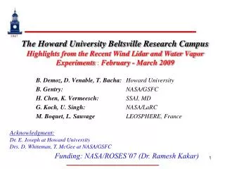
PSU HU-Beltsville Research Campus (HU-BRC): • Uniqueness of Site • Semi-urban site • Major Pollution corridor • Integrate Science and Education • Extensive instrumentation • Extensive collaboration with other agency • A GRUAN nominated site MDE Major Pollution Transport corridor UMBC BWI Airport HU Beltsville UMD Dulles Airport Sterling (NWS) NASA/GSFC National Airport Wallops UMD
Aerial View of Site Office/Shops/Labs Latitude: +39º 03’ 15.117’’ Longitude: -76º 52’ 39.448’’ Elevation: 53.2 m Profiler MDE C-Band Radar Full Air Quality Radiation Bldg GPS (X2) Ceilometer MWR All Sky 31 Met Tower 8-levels T/RH Flux, Net rad Soil Moisture Chemistry Raman ALVIS/AT STROZ GLOW PDB RSOS CORS LidarLaboratory
Opportunities for Federal/State collaborations • NASA/GSFC: focus is satellite and/or research that will lead to global scales and climatic impacts. • Wind, water vapor, Ozone, Temperature, aerosol (and soon Precipitation) • NWS – Sterling/Silver Spring: upper air instrumentation tested • Assess different sonde package performance • Assess ceilometer performance (cloud boundaries) • Development of the consensus reference concept and student mentoring • NOAA/EPA: will forecast aerosol/Ozone. • Model PBL/Flux verification • Maryland Department of Environment • Collaborative pollution and state variable monitoring • Summer Ozone sonde launches
Wind Lidar Experiment: Goals • Develop understanding of direct detection (GLOW) Doppler lidar wind performance for various aerosol loading conditions (pollution, cirrus) • Develop a data base archive for wind measurements for the different seasons. • Participate in the intercomparison of coherent and direct detection Doppler lidars • Compare Doppler lidar wind data to other sensors: current or planned sensors (Profiler, Radio sounding, AMDAR). • Hands-on student training of students
Instruments for Wind Experiment: Wind Goddard Lidar observatory for Winds (GLOW) m/s deg Wavelength 355 nm Telescope/Scanner Aperture 0.45 m Laser Linewidth (FWHH) 80 MHz Laser Energy/Pulse 10-40 mJ Repetition Rate 50 pps Etalon FSR 12 GHz Etalon FWHH 1.7 GHz PMT Quantum Efficiency 20% GLOW mobile Doppler lidar Double-edge filters sample wings of molecular spectrum to measure Doppler shift Time series of wind speed and direction profiles from IHOP_2002
Instruments for Wind Experiment: Wind Goddard Lidar observatory for Winds (GLOW) Wavelength 355 nm Telescope/Scanner Aperture 0.45 m Laser Linewidth (FWHH) 80 MHz Laser Energy/Pulse 10-40 mJ Repetition Rate 50 pps Etalon FSR 12 GHz Etalon FWHH 1.7 GHz PMT Quantum Efficiency 20% GLOW mobile Doppler lidar Double-edge filters sample wings of molecular spectrum to measure Doppler shift Tropospheric wind speed and direction profile comparisons. GLOW lidar vs sonde .
Instruments for Wind Experiment: Wind -Validation Lidar - VALIDAR LaRC
Instruments for Wind Experiment: Aerosol loading - Howard University Raman Lidar (HURL) • Raman Lidar • - ND:YAG – 355nm • - Day/night operation • Water vapor • Aerosol backscattering • All weather operation • Extensive operation with GSFC lidars
Extensive upper air sonde capabilities: WAVES as example • Extensive Radiosonde, Lidar & Satellite Studies • MDE Code red days air quality monitoring • NWS Consensus Reference Activities • NASA Satellite Validation Activities • Lidar Collaboration with (NDACC) at TMF/JPL • Precision surface pressure data • Education, Training, and Networking WAter Vapor Experiment – Sondes/Satellites - WAVES http://ecotronics.com/lidar-misc/WAVES.htm • Payloads flown • Vaisala: RS 92, 90, 80 • Sippican: MII-A, LMS6 • Snow White • CFH • Intermet • Modem • ATM • ECC/Ozone
Instruments for Wind Experiment: WindMDE- 915MHz profiler Radio Acoustic Sounding System (RASS) • Data • Continuous RASS/Profiler Operation • Associated chemistry • 10 m tower • Data available over the web in semi real time • 3-4km reach depending on aerosol load Example of a Weak Frontal Passage Aerosol from lidar and wind from profiler
Example: • Lidar profiler Synergy • Case: Low Level Jet • Shear in direction/speed • Chemical transport • Night time phenom • Good test for DWL
Example: AMDAR performance data from Moninger et al, 2007. Instruments for Wind Experiment ACARS-AMDAR** : data available via web (FSL) Ideal location for wind lidar comparison with AMDAR BWI Airport Dulles Airport ** ACARS - Aircraft Communications Addressing and Reporting System network AMDAR - Aircraft Meteorological Data Reports National Airport
Instruments for Wind Experiment NWS upper air data: developing statistics at IAD • Completed: Characterization of the regional synoptic flow from 1980-2008. • Establish boundaries of wind direction and speed. • Use to characterize GLOW/VALIDAR performancs
DWL Experiment design : 1) Surface + Tower + Profiler + Sonde Full Trop. Wind 2) HURL Aerosol loading 3) 1 + 2 GLOW/VALIDAR characterization!Methods: 1) Case studies 2) Statistical analysis 3) inter-instrument comparisonsTraining: 1) A graduate student is working on theory/operation of GLOW 2) Looking for a student to work on analysis/ meteorology/data integration