Download
1 / 36
400 likes | 659 Views
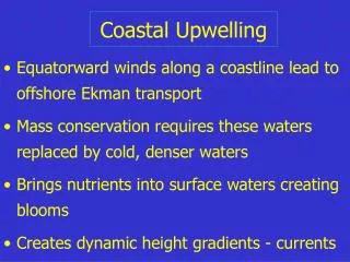
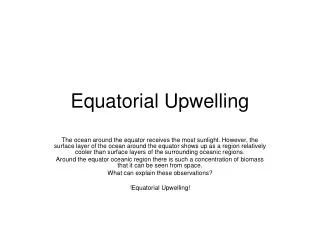
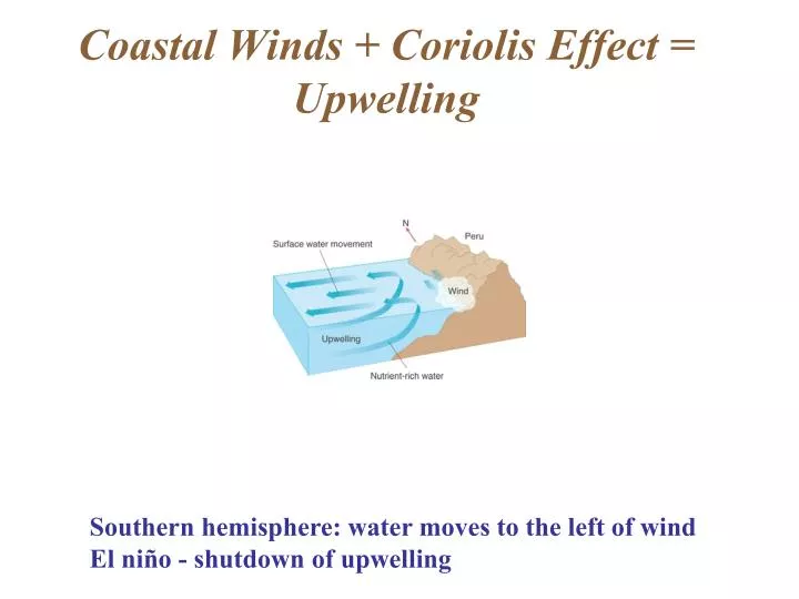
Coastal Winds + Coriolis Effect = Upwelling. Southern hemisphere: water moves to the left of wind El niño - shutdown of upwelling. Oceanic Circulation - Two Components. Wind-driven surface circulation Density-driven thermohaline circulation. Wind-Driven Circulation.

E N D
Coastal Winds + Coriolis Effect = Upwelling Southern hemisphere: water moves to the left of wind El niño - shutdown of upwelling
Oceanic Circulation - Two Components • Wind-driven surface circulation • Density-driven thermohaline circulation
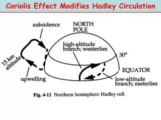
Wind-Driven Circulation • Driven by heating of air near equator, which rises, moves to higher latitude, falls, creating circulation cells that are affected by Earth’s rotation. Wind moves surface water • Prevailing westerlies (40°N & S latitude) • Trade winds (toward the west)
Wind-Driven Circulation • Combination of wind systems and shapes of ocean basins create cyclonic flow known as gyres • Wind plus Coriolis effect tends to concentrate boundary currents on west sides of ocean - creates concentrated currents such as Gulf Stream with deflection at higher latitude
AVHRR (Advanced Very High Resolution Radiometer - Polar Satellite)
Thermohaline Circulation • Water in the ocean can be divided into water masses, identified by distinct temperature, salinity, and other physico-chemical characteristics
Thermohaline Circulation • Thermohaline circulation is movement of ocean water controlled mainly by density characteristics • Controlled by (1) location of formation of water, (2) density, (3) Coriolis effect (to a degree)
Thermohaline Circulation AABW=Antarctic Bottom Water; AAIW = Antarctic Intermediate Water; NADW = North Atlantic Deep Water
Thermohaline Circulation • Water masses • Origin: high latitude surface waters - high salinity, low temp--> high density • Waters sink, move at depth toward lower latitude • Water masses each have a characteristic depth, because of their density, which is largely a function of their high latitude surface origin
Circulation Recap • Coriolis effect - rotation of Earth, prop. to sine of latitude, right deflection in N. Hemisphere, left deflection in S. Hemisphere - upwelling, deflection of currents • Surface circulation - driven by planetary winds, which are controlled by heating, convection, Coriolis effect - gyres, eastern boundary currents • Thermohaline Circulation - driven by density, sinking, surface water brought to deep sea - water masses determined by density
El Niño - Global Phenomenon • Periodic - every few years • Warm water moves eastward across Pacific Ocean • Eastern tropical and subtropical Pacific becomes warm, thermocline deepens • Causes mortality of clams, fishes, from heat shock • Strongly affects weather in eastern Pacific, storms increase; droughts in western Pacific
Global Climate Change • Greenhouse effect • Ocean warming
Warming Also on Local Scale Woods Hole, MA Baltic Sea
Predicted Effects on Climate and Circulation • Sea surface temperature warming • Sea level rise (expansion of seawater volume with increasing temperature) • Sea level rise (melting of continental glaciers) • Seawater acidification (due to increased dissolved carbon dioxide)
The Ocean Coastal Processes
Waves • Dimensions Wave LengthL Amplitude H VelocityV=L/t Whole water column is NOT moving horizontally!
Waves • When depth < L/2: waves “feel bottom” • When H/L > 1/7: wave is unstable and collapses (breaks)
Beaches • Many beaches exposed to direct wave and erosive action • Some sandy beaches are more protected, very broad with low slope and dissipate wave energy near the low tide mark Low tide Protected beach Exposed beach
Beaches • Profile more gentle in summer; fall and winter storms cause erosion and a steeper profile
Beaches • Longshore currents, riptides are common features, causing erosion and transport of sand
Tides Moon: grav. effect is 6 x sun
Spring Tides - greatest vertical tidal range, highest high, lowest low • Neap tides - smallest vertical tidal range
Tides • Tides differ in different areas; function of basin shape, basin size, latitude • Amplitude varies, evenness of semidiurnal tide varies
Tides Connecticut, even tides Washington State, uneven tides
Estuaries • Body of water where freshwater source from land mixes with seawater • Often results in strong salinity gradient from river to ocean • Salinity may be higher at bottom and lower at top, owing to source of river water that comes to lay on top of sea water below or mixes with the sea water to some degree
Estuaries Chesapeake Bay with summer surface salinity. Dark blue areas: tributaries have salinity < 10 o/oo
Circulation in a Coastal Fjord • Reduced exchange of fjord’s bottom waters, combined with density stratification and respiration, results in low oxygen in bottom waters