Download
1 / 48
500 likes | 684 Views
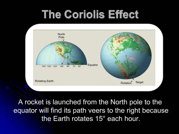
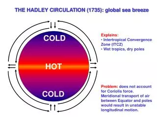
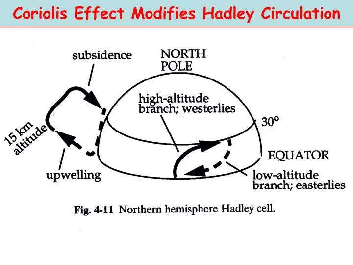
Coriolis Effect Modifies Hadley Circulation. Modified Hadley Circulation. *. Vertical motions upwelling: rising air subsidence: sinking air. Horizontal motions convergence: coming together divergence: spreading apart. “Seeing” Hadley Circulation. H. H. H. H. H. H.

E N D
Modified Hadley Circulation * Vertical motions upwelling: rising air subsidence: sinking air Horizontal motions convergence: coming together divergence: spreading apart
“Seeing” Hadley Circulation H H H H H H Mean Surface Pressure Contours Lines of constant pressure (isobars). More closely spaced lines: steeper change in pressure
Announcements • Posters: March 12 – 13 during lecture; buy one poster board (~ 4’x4’) per group • Groups to be solidified by next Friday • SEE WEBSITE FOR MORE DETAILS • Office Hours today 4-5 pm (506 or 510 ATG) and 5-6 pm (406 ATG) • Another problem set will be posted soon. Beware of quizzes in discussion sections…
This Week • Finish Chapter 4 of text • Regional Climates Continued • Midlatitude Circulation • Land/Ocean Contrasts • Global Water Cycle
Hadley Circulation and Regional Climates • World’s largest deserts • Wet and dry seasons in the Tropics • The Trade Winds
World’s Deserts Not shown: Polar Regions!
World’s Deserts Desert dust blows from W. Sahara and N. Morocco over Canary Islands. Desert dust is a source of nutrients to ocean and land biota (often a world away).
All desert areas (low annual precipitation) occur in regions of general subsidence • True • False
Suppose you wanted to the take Presidents’ Day vacation (Feb) in the sunny and warm tropics. Because you want sunny dry weather you choose • Costa Rica (NH) • Amazonia (SH)
Seasonal Shift in Hadley Circulation ITCZ location shifts N-S depending on season. Leads to wet and dry seasons in the tropics.
Hadley Circulation Summary Low surface pressure near equator convergence ITCZ ITCZ: rainy! location moves N or S with seasons causing WET and DRY seasons in the tropics High altitude branches WESTERLY @ 15 – 30 N/S due to Coriolis Force and PGF (geostrophic flow) Subsiding branches located around 30o N and S DESERTS and high surface pressure Surface flow towards equator is northeasterly in NH and southeasterly in SH TRADE WINDS
Mid-latitude Circulation • Westerly flow both NH and SH • Strong temperature gradient gives rise cold/warm fronts (moving air masses) • Cyclones and Anticyclones
Warm/Cold Fronts Subsiding Hadley Brach Strong T gradients Higher P Higher P Lower P
Flow Around High and Low Pressure Centers Upper-level flow geostrophic: parallel to isobars. In NH flow counterclockwise around Lowcyclonic flow In NH flow clockwise around Highanticyclonic flow H L Low Pressure Center High Pressure Center
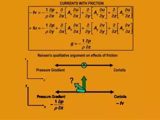
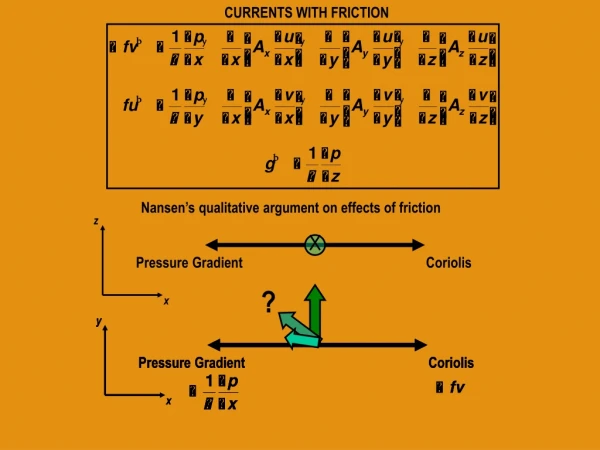
Surface Flow Impacted by Friction Forces PGF Friction Coriolis Actual Flow direction Low Pressure High Pressure Friction causes flow to move away from high pressure, but towards low pressure.
Surface-level Flow affected by Friction Centers of low or high pressure at surface induce flow that spirals in or out, respectively. Convergence/uplift—Stormy Divergence/Subsidence - Nice H L Low Pressure Center High Pressure Center anticyclones cyclones
Midlatitude Average Circulation (Summary) • Westerly flow 35 – 55 N/S • Large latitudinal temperature gradients – warm and cold fronts induce storminess • Low pressure centers are wet/rainy (storms) high pressure centers are dry/sunny
Where would you expect “continentality” to be greatest? • Northern Hemisphere • Southern Hemisphere
Continentality-Find the Continents 56 44 4 Contours show annual temperature range: Tsummer - Twinter
Diurnal (Daily) Sea Breeze Day Night
Monsoonal Circulation H January July L Similar to diurnal sea breeze but on larger spatial and temporal (seasonal) scales.
Atmospheric Circulation Summary • Three major N – S circulation cells in each hemisphere (Hadley, Midlatitudes, Polar) • Tropics: surface level easterlies (trades), ITCZ, and subsidence zones (30N/S) • Midlatitudes: westerly flow, frontal storms • Land/Ocean contrasts: monsoonal circulation, diurnal sea breeze, continentality
Ocean Circulation and Climate Reading: Chapter 5
Atmosphere-Ocean Couplings • Heat Exchange • Momentum Exchange (surface wind stress) • Moisture/Gas Exchange (water and carbon cycles)
Heat Transport by Ocean and Atmosphere Tropics Midlatitudes Polar regions
Key Ocean Properties • Ocean water is salty ~ 30 g salt in 1 liter • Ocean heated from above warm surface water, cold deep ocean • Vertical mixing determined by buoyancy • warm water less dense, saltier water more dense • Vertical mixing suppressed: surface vs. deep circulation
Gulf Stream western branch of mid-Atlantic gyre AVHRR Satellite measurement of Sea Surface T
Convergence And Divergence Net convergence of surface water in center of gyres Net divergence at eastern ocean boundaries and equator Surface ocean Wind Equator
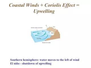
Marine Stratus Clouds Surface winds Ocean surface flow • Eastern-boundary coastal upwelling • Cold water cools air Cloud formation
Where do you expect the coldest sea surface temperatures? • Eastern ocean boundaries • Western ocean boundaries
Sea Surface Temperatures monthly mean SST animation Observe the following • Latitudinal distribution of solar radiation • Heat exchange with atmosphere • Circulation patterns (e.g. upwelling)
Deep Ocean Circulation • A SLOW process • Timescale to overturn ~ 1000 years • Lots of water (1.37x10⁹ km3) and suppressed vertical mixing • Driven by formation of cold salty surface water
Salinity Salinity is measured in parts per thousand
Thermo-haline Circulation (temperature-salty) Ocean-Atm heat transfer Cold salty water Mixed layer ~ 1 km deep Sea ice Middle and deep ocean Net sinking: Deep Water formation Lower latitudes High latitudes
Sea ice influence on the ocean • Reduces the influence of the winds • Insulates the ocean (prevents heat loss) • Rejects salt when it grows / Adds freshwater when it melts
Thermohaline Circulation Importance • Deep ocean is an enormous reservoir for heat and dissolved gases like CO2 • Overturning brings nutrients up to surface biota photosynthetic uptake of CO2 • Maintains transport of heat to higher latitudes, moderate latitudinal T gradients