Download
1 / 41
420 likes | 574 Views
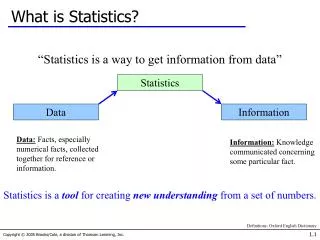
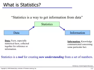
Background According to the Statistics Act 6, 1999 Statistics SA is required to develop and maintain registers or lists for the production of statistics. The organisation relies on the Dwelling Frame to develop and maintain a complete frame of dwelling units in South Africa for:

E N D
Background • According to the Statistics Act 6, 1999 Statistics SA is • required to develop and maintain registers or lists for the • production of statistics. • The organisation relies on the Dwelling Frame to develop • and maintain a complete frame of dwelling units in South • Africa for: • the selection of samples for household and other surveys • conducting censuses
Statistics SA aims to have in place for Census 2011 an up-to-date database that will determine: 1. The location - Spatial /XY Coordinates and 2. The characteristics or attributes of every dwelling unit in the country of which 12 million are estimated dwelling units and other structures - hospitals, old age homes, prisons, and orphanages etc.
DF Project Objectives • To verify existing data on completed registers • To capture outstanding/missing data • To maintain the data for all dwellings spatially and • characteristically in the office as well as in the field
Purpose of the DF Project • To provide a true and accurate reflection of what is actually • on the ground in the form of digital representation • To acquire detailed information regarding the use of • structure • To minimise sample bias • To be produce a digital Enumerator’s Summary Book
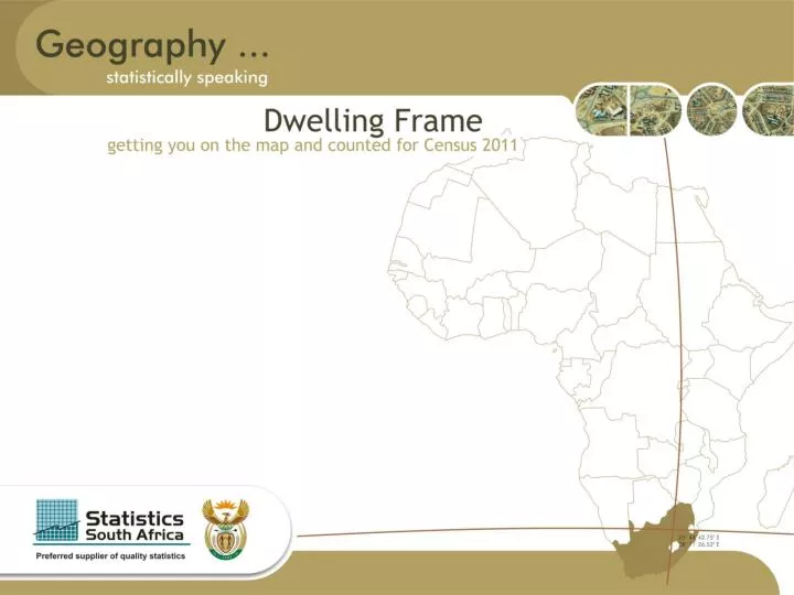
Project Scope Participating Provinces Eastern Cape, Free State, Gauteng, KwaZulu-Natal, Mumphalanga, North-West, Northern Cape, and Western Cape. Total number of regions: 45 Total Number of Municipalities: 211
Time-Frames Publicity: 21 April 2008 – 07 December 2009 Fieldwork: 03 November 2008 – 07 December 2009
DF Project Overview • Detail Specifications Per Geography Type • Imagery forms the basis from which the DF will be implemented & was used for the spatial data capturing of dwellings and backdrop for map production. Imagery ensures complete coverage of municipalities and aids the planning of fieldwork unit allocation. • The imagery layer in order of priority will consist of: • - imagery received from CDSM • - imagery commissioned by Stats SA to fill gaps in the CDSM layer • - imagery flown by metropolitan and local municipalities • - Spot 5 – 2.5 m resolution
Spatial Data Integration Efforts were made to obtain and integrate all existing data and to integrate data received from existing municipal data where available, AfriGIS NAD, CS Spatial Points and ESKOM spatial points to avoid duplication. Spatial Points (dot-dot) The purpose of the spatial point phase was to capture all potential structures within a municipality to ensure that no areas – villages, small towns and farms will be omitted during the fieldwork verification phase of project.
Advantages of Spatial Points Per Municipality • Provide a clear indication of the number of points • to be visited in a municipality. • Are the primary unit for data collection which needs to be • visited in the field to collect the required attributes. • Enhances quality – enables supervisors to check whether • fieldworkers have visited all structures within work units • which make up the municipality. • Hence, the number of spatial points will act as • benchmark for future listings to be collected.
Workload Unit Delineation • EAs will be the work unit for fieldwork and progress • management. • On project level the work unit is the municipality. • Supervisor Areas (a collection of EAs) will be allocated • to and reported on by fieldwork supervisors.
Map Production • Purpose is to provide hard copies of maps to fieldworkers for locating the work units as well as identifying each individual structure within work units. • Type of maps to be used: • District • Orientation • Index • Supervisor unit
Fieldwork • Before Fieldwork… • A data dictionary has been developed to capture all • variables required by the dwelling frame per individual • structure. Its main focus is to minimise alpha numeric data • capture fields and to optimise the use of tick boxes to guide • data standardisation. It caters for all geography types as well • including options for new dwellings not predefined by a dot • whose associated barcode can be captured in the field for the • first time. • Aerial photographs have proven to be sufficient in accurate • collection of spatial points in most municipalities.
Fieldwork cont: • In areas where Spot 5 satellite imagery is used, accuracy will • be confirmed by the overlaying of cadastral data. • Where the satellite imagery accuracy could not be confirmed • as a result of outdated imagery, the non-existence of imagery • or where new development has occurred, a team with • differential GPS (DGPS) devices, will be responsible for • capturing these areas as well as the applicable attribute data • per dwelling unit. • A similar methodology will be followed for high density areas – • informal settlements. • Various geography types will need the necessarily appropriate • fieldwork methodologies.
Fieldwork cont. • During the fieldwork phase the following will be executed: • Each dot captured during dot-dot process to be visited by fieldworker teams. • Verifying structures and collecting all relevant attributes. • Capturing points and attributes for structures not given spatial points during the office exercise. • Capturing structures not visible on aerial photography or structures or not identified during dot-dot process. • Notify DGPS teams of areas where the capture of dwellings • or settlements need to take place as a result of outdated aerial photographs. • Transmitting reports via GPSR to head office once the attribute list is completed at 30 minutes intervals.
Fieldwork cont. • Supervisors will manage the data collection process in their designated work unit areas and will be responsible for: • Ensuring 100% coverage of individual work units • 100% coverage of supervisor units • Maps are distributed to fieldworkers in their work units • Work is allocated to the fieldworkers • Ensuring clarification and addressing of issues resulting • from automated QA measures • Asset management of devices and its maintenance, • trouble-shooting • Ensuring fieldworkers are in the correct locality to implement • data capturing • Check a sample of work done by fieldworkers
Data Quality Management • To provide a system having the ability to monitor progress, perform automated QA checks, generate reports and integrate disparate data as received from various sources to result in an integrated dwelling frame database. • Data Quality Management to include processes which will ensure data quality, transfer of data between field and head office as well as confirming that the data is in the format to be imported into the Geo-database.
Initial Field Quality Assurance • Supervisors to perform random completeness checks while • fieldworkers are populating attributes. Necessary to ensure • fieldworkers understand and comprehend the methodology, • resulting in accurate populating of attributes. • Second QA check will be an automated quality assurance • process that will be enforced on two levels, i.e. • 1. Device based – basic checks to ensure data dictionary is • completed correctly and all compulsory fields populated • before transmitted via GPRS to head office server. • 2. From device to head office server – Will automatically send • records to head office server via GPRS. Followed by • quality checks to ensure successful transmission of all • fields to be captured.
Data Transfer • Devices are set up to only send DATA by means of • GPSR technology. • Once data is received on the head office server, basic • checks are done. Data fields completed correctly will be • forwarded to a quality assurance server where • automated quality assurance interpretation is done. • Data then forwarded to the Geo-database where it is • accessed for spatial quality assurance purposes. • Once QA is passed and a municipality completed in • coverage terms, data will be made available for the • creation of place names, EA demarcation and the • numbering of dwellings where applicable.
Field Quality Assurance • The record selection for field QA is an automated process • Selected records will be transferred to supervisor within • minutes after data initially sent to HO to ensure corrections • on work while fieldworkers are still in same area • Completed QA records will be sent via GPRS and • measured against the original fieldworker’s collected points • resulting in a QA report. • To manage quality of fieldworker’s outputs, report will be • compile denoting the number of times office QA was failed. • Supervisors will be third party QA team to check attributes • for selected records in field. Should data fail the QA check, • message will be sent to supervisors informing them to • redirect the fieldworker to redo total workload are. • Data which failed QA will be deleted from server.
Import into Geo-database • Once the data has passed both field and office QA, it will be directed to specific feature datasets providing access for place name & EA demarcation as well as the numbering of dwellings. • Physical Numbering • Last process in Dwelling Frame • Purposes of creating a unique number that is allocated to, • and physically displayed on each dwelling by means of a • number plate.
Publicity • Purpose • To create a receptive, participative and engaged environment for the DF Project by addressing stakeholders, gatekeepers and other community leaders in all settlement types that will result in : • access obtained for fieldworkers by following the settlement • type protocol • effective participation and support of all stakeholders • publicising the project before and during the fieldwork phase
Objectives of the Publicity Campaign • To successfully identify and communicate with all relevant • stakeholders the project objectives and thereby establishing • strong support and solid buy-in for the project • To have created a receptive stakeholder environment by • December 2009 • To create a database of stakeholders, gatekeepers and • community leaders’ profile as well as profiles on communities