Download
1 / 30
441 likes | 1.94k Views
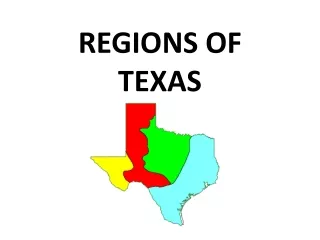
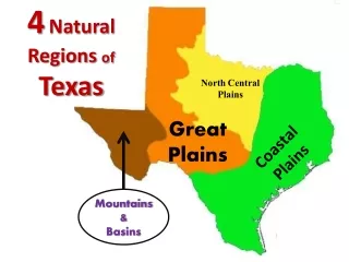
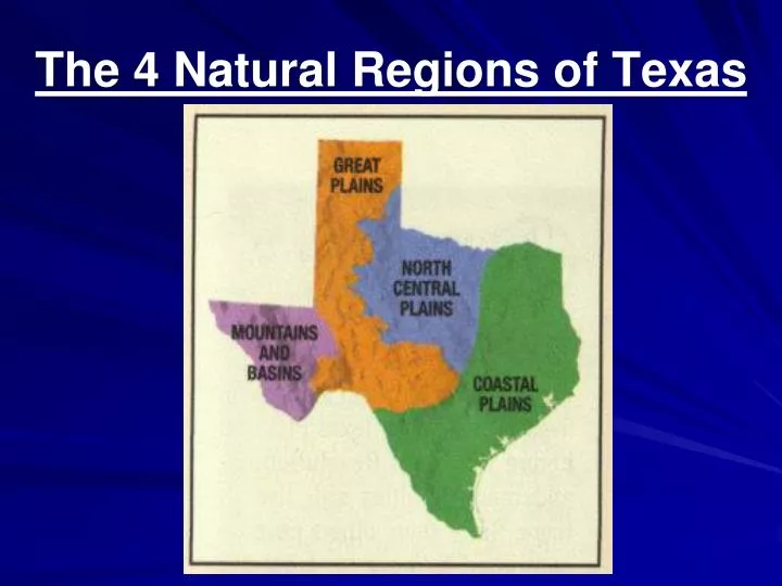
The 4 Natural Regions of Texas. Natural Regions. Are determined by physical geography features such as landforms, climate, vegetation. The 4 natural regions of Texas are: North Central Plains -Just to the west of Dallas, includes Ft. Worth Coastal Plains

E N D
Natural Regions • Are determined by physical geography features such as landforms, climate, vegetation.
The 4 natural regions of Texas are: • North Central Plains -Just to the west of Dallas, includes Ft. Worth • Coastal Plains • This region is along the Gulf of Mexico • Great Plains • Mostly the northern part of the state or the Panhandle • Mountains and Basins • West Texas where the Mountains are.
Subregions • Each Natural Region of Texas is divided into smaller subregions. There are 11 in all
Coastal Plains Region • The largest of all the four regions. • Makes up nearly 1/3 of Texas • 2/3rds of all Texans live in the Coastal Plains • Industries include oil, natural gas, and seafood. • Cities in the Coastal Plains: • Dallas • Austin • Houston • San Antonio
Subregions of the Coastal Plains: • Piney Woods • Post Oak Belt • Gulf Coastal Plain • Blackland Prairie • South Texas Plain
A Pine forest that stretches from the Louisiana border west 125 miles. North-East Texas It is the rainiest portion of the state. 45-60 inches Important due to its Timber Industry. -Piney Woods
An area of oak, hickory, and other trees, with a scattering of prairie grasses Just east of Dallas includes the city of Austin -Post Oak Belt
Very narrow but long in Central Texas, it is mostly flat and with small trees. Dallas is located in this subregion -Blackland Prairie
-Gulf Coast Plain • An area that follows the coast of the Gulf of Mexico and inland about 30-60 miles -Includes the City of Houston
South of San Antonio to the Mexican border. An area 270 miles long and 250 miles wide. The climate is warm year round. -South Texas Plains
North Central Plains • The North Central Plains is an area of plains covered by small oak trees, brush, and scattered grasses. • The Region gets higher in elevation and dryer the farther the west you go • Cities: -Ft. Worth -Abilene -Wichita Falls
Subregions of the North Central Plains: • Grand Prairie • Rolling Plains • Cross Timbers
West-Central Texas. The vegetation consists mostly of tall grasses and scattered trees. -Grand Prairie
-Cross Timbers • Divided into Eastern and Western parts as it wraps around the Grand Prairie • Soil allows it to grow trees such as oaks, hickories, pecans, and elms. • Ft. Worth is in this Subregion
This area is largely a steppe. A vast treeless plain. Elevation of the region varies from 900 feet in the east to 2,000 feet in the west Abilene is in this subregion. -Rolling Plains
Great Plains • The Great Plains lies in the northern and central part of the state. • It includes the panhandle and the hill country (near Austin) • Cities: • Amarillo • Lubbock • Odessa • Midland
Subregions of the Great Plains • Llano Basin • Edwards Plateau • High Plains
Lies in almost the center of Texas. Known as the hill country because of its huge granite hills. Just west of Austin -Llano Basin
Southern part of the Great Plains The Edwards Aquifer supplies water for much of the area. -Edwards Plateau
Also called the Llano Estacado or the panhandle of Texas One of the flattest areas in the world Large farming area -High Plains
Palo Duro Canyon PALO DURO CANYON
Mountains and Basins Region • Has NO SUBREGIONS • Has highest point of Texas, Guadalupe Peak at 8,749 feet. • Cities: • El Paso
Tall mountains separated by large basins and valleys. Trees grow in the mountains. Cactus, shrubs, and short grasses grow in the basins and valleys. Very little rain.
Texas Escarpments • An escarpment is a transition between different geographic regions. -Usually a steep elevation increase, like a cliff or steep slope.
Balcones Escarpment is a geologic fault zone several miles wide between the Coastal and Great Plains
The Caprock Escarpment is a geographical transition point in Texas between the High Plains to the west and the North Central Plains to the east.