Download
1 / 59
610 likes | 862 Views
Join Big Tex in exploring the unique regions of Texas, from the towering mountains and basins in the west to the coastal plains in the east. Learn about the physical and human characteristics, indigenous flora and fauna, as well as the diverse industries and landmarks that define each region. Get ready for an educational journey across the Lone Star State!

E N D
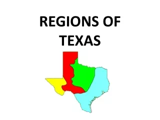
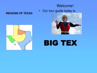
REGIONS OF TEXAS Welcome! • Our tour guide today is BIG TEX
To help you learn the order of the Rivers. From top-to-bottom Backward “C”
Physical Characteristics • Mountains: Rocky, Davis, Chisos, Guadalupe • Rivers: Rio Grande, Pecos • Deserts: Big Bend National Park • Climate: hot days, cold nights, hot short summer, cold winters ***Has ALL the mountains in Texas!!
Human Characteristics • City: El Paso • Industries: cattle, sheep, & goat ranching • Big Bend National Park • Dams
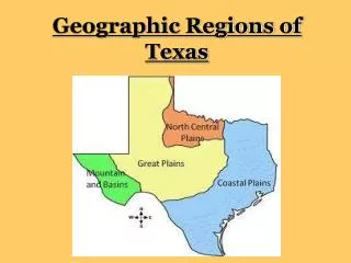
Mountains and Basins Region A basin is a low, bowl-shaped land with higher ground all around it. The basins in this Texas region are deserts.
Our first stop is the Mountains and Basins region! The Mountains and Basins region is the most western region of Texas. It has many mountain ranges and is very dry. Mountains and Basins Region
The mountains in Texas are part of the Rocky Mountains which stretch through the western United States from Mexico to Canada. The Texas Rocky Mountains are made up of many small mountain ranges. Mountains and Basins Region of Texas
The Davis Mountains are in the center of the Mountains and Basins region.
The Chisos Mountains are located in the Big Bend National Park.
Guadalupe Peak is the highest point in Texas at 8,749 feet above sea level.
The Chihuahuan Desert is located in this region. Prickly pear cactus grows here.
Big Bend National Park is located in a gigantic bend in the Rio Grande River. 99% of the park is desert!
Did you know the largest pterodactyl bone ever discovered was found right here in Big Bend National Park? It had a wingspan of 51 feet and was found by Douglas A. Lawson in 1971.
This is the city of El Paso. The name is Spanish for “The Pass”. El Paso is the largest city in this region of Texas.
Mountain and Basin Region Let’s get off the bus and visit Big Bend National Park.
SECOND STOP! Coastal Plains Region
The Coast Plains are mostly flat land that lies alongside an ocean. Coast Plains cover near one third of the state of Texas! Coastal Plains Region
Physical Characteristics • Plains, desert, hills, piney woods • Balcones Escarpment • ALL rivers flow west into Gulf of Mexico • Wrong way…take water from dry regions to the wettest • Climate: mild • Long, hot, humid summers • Most rainfall in TX
Human Characteristics • Highway system • Flat land, so location of most major cities: Dallas, Houston, Austin, San Antonio • Dams • PORTS • Timber, agriculture, oil, gas, technology, industry, and education
This the Piney Woods of East Texas. It was once the home of the Caddo Indians.
Our state bird, the Mockingbird, lives here. They got their name from their unique ability to copy or “mock” other birds. Another state symbol is found in abundance here. The pecan tree is the state tree of Texas. Pecan tree Mocking bird
Weather in the Coastal Plains region is usually mild. That means that winters are short and warm compared to other parts of the country. Summers are long, hot, and humid.
There are lots of rivers and lakes in this region. Perfect for fishing and water sports. Fishing in Texas
The Coastal Plains of Texas lie alongside an ocean. All rivers that flow west drain into the Gulf of Mexico. Many people visit the beaches that lie along Texas.
Shipping is a huge industry in this region. Corpus Christi and Houston have huge ports where ships from all over the world visit to load and unload goods. A cargo ship Corpus Christi Houston
Farming and ranching are important industries in the Coastal Plains region. In Kingsville, you will find King Ranch. It was started in the late 1800s by Captain Richard King and his wife Henrietta. It is still one of the largest cattle ranches in Texas today. In the southern most area of Texas known as “The Valley”, some crops are grown all year due to the warm weather. Crops include cotton, sugar cane, citric fruits, soybeans, and corn.
Oil is found in the Coastal Plains region. These tall structures are oil derricks. Many people call the oil found in Texas “Black Texas Tea”.
Many large cities are located in the Coast Plains including Dallas, Austin, and Houston. Although Austin is our state’s capital, Houston is the state’s largest city. Houston is also the fourth largest city in the U.S.! Houston Austin Dallas
Coastal Plains Region Let’s visit NASA, located in Clear Lake southeast of Houston
Our third stop is the Central Plains Region! The Central Plains region is in the center of Texas. It has a little higher elevation than the Coastal Plains and is covered with rolling prairies. Central Plains Region
Physical Characteristics • This region is known for its rolling hills/praries. • The Central Plains are slightly higher than the Coastal Plains. • Climate: hot short summers, cool to cold winters
Human Characteristics • Many cattle ranches are located here. • It is rural, not highly populated. • Fort Worth, Abilene • Several military bases • Manufacturing
The Central Plains Region is a rural area. This means a small population and a lot of open country. It has warm summers and cool winters. There are many cattle ranches and farms here.
This region does have some wild weather. During the spring there is a chance of tornados. These are funnel-shaped storms with swirling winds that do a lot of a damage to a community.
Fort Worth is one of the larger cities in the Central Plains region. It is known for its stockyards and cowboys.
Fort Worth was one of many stops along the famous cattle drive trail known as the Chisholm Trail. The Chisholm Trail was started by a Cherokee trader.
Cowboys and cowgirls in this region still work on cattle ranches. Many compete in rodeos around the country.
Did you know that after the Civil War, about one third of the Texas cowboys were African-American or Mexican-American? And several were women!
Central Plains Region Ft. Worth.
Our last stop is the Great Plains Region! Most of the Texas Panhandle is located here. Great Plains Region
Physical Characteristics • Very high and flat • Canyons, escarpments, plains, aquifers, plateaus • Llano Estocado • Palo Duro Canyon • Balcones Escarpment (southern border) • Climate: hot summers, cold winters • VERY dry….little rain
Human Characteristics • Cities: Amarillo, Lubbock • Irrigation • Important crops: cotton and wheat • Railroads • Ranching and agriculture • Wind farms • Dams (Amistad) • Oil and Gas
Land in the Great Plains region very high in elevation, but is still very flat.
In the southern part of the Great Plains is a landform called the Edwards Plateau. It’s very high and flat, like a table. The southern and eastern parts have hills though. This area of Texas is often called the “Hill Country”.