Download

1 / 19
230 likes | 720 Views
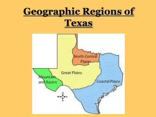
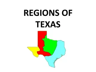
Regions of texas. Mountains and Basins Region ~ Location, Landform, Important Cities. Mountains and basins ~ location. Far west Texas East border near Pecos River South border is the Rio Grande North border is New Mexico . Mountains and Basins Region.

E N D
Regions of texas Mountains and Basins Region ~ Location, Landform, Important Cities
Mountains and basins ~ location • Far west Texas • East border near Pecos River • South border is the Rio Grande • North border is New Mexico Mountains and Basins Region
Mountains and basins ~ landforms • 150 mountains in the mountain ranges • Plateaus and basins • Plateau ~ a high, flat area • Basin ~ hollow or depressed area with no outlet for water Guadalupe Mountains Basin in Big Bend
Mountains and basins ~ landforms • Deserts • Pecos and Rio Grande Rivers • Big Bend National Park Both pictures are of the Rio Grande
Mountains and basins ~ important cities • El Paso • Most far western city in the state • Military base • Pecos • Cattle drives went through this city • Chisholm Trail and Loving-Goodnight Trail went through this city
Mountains and basins ~ important cities • Kermit & Monahans in Permian Basin area • Kermit located at the “L” of the end of the Panhandle • Monahans is where native Comanches, Mescalaro, and Lipan Apache Indians once roamed • Fort Davis, Marfa, & Alpine in Mountain area • Marfa began as a Railroad water stop
The Regions of texas Mountains and Basins Region ~ Climate, Plants, Animals
Mountains and basins region ~ climate What can you infer about the climate in this location?
Mountains and basins ~ climate • Driest part of state • 8 inches of rain per year, 20 in mountains • Hot days, cool nights Storm east of El Paso
Mountains and basins ~ Plants • Short grasses, shrubs, desert plants in plateaus and basins • Pine forests in mountains Cholla cactus
Mountains and basins ~ Animals • Javelina • Roadrunner • Gray-Banded King Snake
Mountains and basins ~ Animals • Lizard • Scorpion
Mountains and basins ~ industry • Ranching - cattle, sheep, goat • Farming - cotton, fruits, vegetables, cantaloupes (irrigation in El Paso and Pecos River Valley) • Oil and gas - part of Permian Basin
The regions of texas Final Assessment
Final assessment • Look back over your notes on all four Texas Regions. • Think about what makes each one unique. • Think about what you don’t like about a particular region. • Which region would you prefer to live in? Why? What makes that region the best one of all?
Final Assessment • Make a circle map for the region you think is the best one of all ~ the one you would like to live in. • Write a paper explaining why you think that region is the best. Be sure that your thoughts make sense. Make a rough draft. • Copy your paper over neatly and turn in with your circle map.