Download
1 / 51
510 likes | 542 Views
Discover the unique characteristics, landscapes, and economies of the Coastal Plains and North Central Plains regions in Texas. From the lush piney woods to the rolling grassy prairies, explore the rich history and resources that define these areas. Learn about the major cities, landmarks, economic activities, and climate that shape life in these regions. Unveil the beauty and opportunities that await in the heart of Texas!

E N D
https://prezi.com/q9evsteut3cu/texas-regions-and-subregions/#https://prezi.com/q9evsteut3cu/texas-regions-and-subregions/#
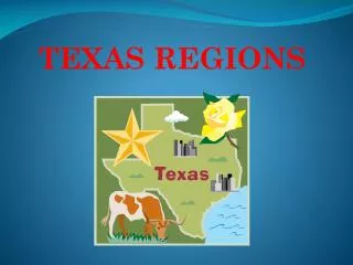
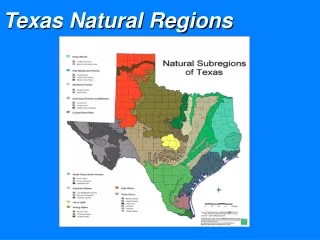
Can you name the 4 Regions of Texas? • GP = GREAT PLAINS • CP= CENTRAL PLAINS • MB=MOUNTAINS & BASINS • C= COASTAL PLAINS
The regions of Texas are… • C= COASTAL PLAINS • CP= CENTRAL PLAINS (or North Central Plains) • GP= GREAT PLAINS • MB= MOUNTAINS AND BASINS
Regions and Subregions of Texas Title Compass Rose Legend
COASTAL PLAINS REGION COASTAL PLAINS
PHYSICAL GEOGRAPHY OF COASTAL PLAINS REGION • REGION COVERS 1/3 OF THE LAND OF TEXAS • PINEY WOODS ALONG TEXAS-LOUISIANA BORDER. • LOWEST ELEVATION OF ALL TEXAS REGIONS • MOST OF THE GULF COAST IS MADE UP OF MARSHES-WETLANDS WHERE TALL GRASSES GROW.
PHYSICAL GEOGRAPHY & Landforms == COASTAL PLAINS REGION • Mostly flat, coastal, lakes, piney woods • Forest = Roughly 12 million acres • Rivers = Colorado, Brazos, Trinity • PLANTS & CROPS= prairie grass, timber, rice • Wildflowers, bluebonnets, brush • ANIMALS= cattle, horses, geese • WATER RESOURCES= Gulf of Mexico, Guadalupe River, Sabine River, Rio Grande • NATURAL RESOURCES: timber, oil, gas
SUB-REGIONS OF THE COASTAL PLAINS • THERE ARE 5 SUB-REGIONS: (smaller regions) • Piney Woods (heavily wooded in East Texas) • Post Oak Belt = largest city is Bryan-College Station!!! WHOOP! • Blackland Prairie = rich black soil great for farming • Gulf Coastal Plain = mainland near coast/full of bayous • South Texas Plain = includes Rio Grande Valley
Climate of the COASTAL PLAINS REGION • Hot and humid summers; mild winters • Tornadoes / hurricanes • Wettest of the four regions • Coastal plains get the most rainfall, yet still prone to drought
COASTAL Plains CITIES……… • AUSTIN (ON BORDER) • HOUSTON • DALLAS • SAN ANTONIO • CORPUS CHRISTI
COASTAL Plains ECONOMY = JOBS/INDUSTRY • OCEAN LIFE, FISHING, AND SHRIMPING • TIMBER = PINE TREES; SWINE; REFINERIES; CATTLE RANCHING; FARMING • OIL/PETROLEUM: OFF SHORE OIL RIGS / DRILLING **INTERESTING FACTS: ALAMO=SAN ANTONIO KING RANCH=KINGSVILLE
COASTAL Plains LANDMARKS • PINEY WOODS • ALAMO (SAN ANTONIO) • SAN JACINTO MONUMENT (HOUSTON) • URBAN TRIANGLE (DALLAS-HOUSTON-SAN ANTONIO) 2/3 OF POPULATION IN THIS AREA.
Coastal Plains Region Major Landform: Padre Island and Balcones Escarpment *mostly flat, coastal, lakes, piney woods forest Climate: Hot/warm and wet, humid, tornadoes, hurricanes 30-55 inches of rain per year; some floods Waterways: Trinity River and Rio Grande River, Colorado River, Brazos River (all rivers flow through this region) Major Cities: Dallas, Austin, Houston, San Antonio, Corpus Christi Landmarks/Points of Interest: The Alamo, NASA, King Ranch, Piney Woods, San Jacinto Monument Characteristics: Pine trees, plains, highway system, and most major cities Economic Activities: Fishing, farm/ranching, oil and gas, refineries, and tourism
North Central Plains NORTH CENTRAL PLAINS
PHYSICAL GEOGRAPHY OF THE NORTH CENTRAL PLAINS • THE RED RIVER DIVIDES TEXAS FROM OKLAHOMA. • MADE UP OF ROLLING GRASSY PRAIRIES
landforms of Central Plains • FLAT, ROLLING HILLS, BLACKLAND • MESQUITE TREES, SMALL TREES • EDWARDS AQUIFER, SPRINGS, GUADALUPE RIVER • Rivers, Escarpments, Grasslands, Hardwood trees • HIGHER ELEVATION
NORTH CENTRAL PLANTS, CROPS, ANIMALS • FARMING, RANCHING, OIL • & NATURAL GAS DRILLING • ALFALFA HAY, GRASSLANDS • HORSES, SHEEP AND WOOL, DAIRY CATTLE, • ANGORA GOATS • MOHAIN WOOL, DEER HUNTING • PECANS, PEANUTS, PEACHES
North Central Plains Climate & VEGETATION • “HOT” summers • Prone to drought / very dry • Cool in winter • Desert-like • MOSTLY RURAL GRASSLANDS, THICK GRASSES, FRUIT, VEGETABLE & OAT CROPS • FERTILE SOIL
Sub RegIONS: NATURAL RESOURCES = CENTRAL PLAINS • LIMESTONE • OIL & NATURAL GAS • Grand Prairie • Western Cross Timbers • Rolling Plains = • steep large treeless plains
NORTH CENTRAL PLAINS ECONOMY (JOBS) • RAILROADS, FARMING & RANCHING, • WILDLIFE MANAGEMENT • OIL & NATURAL GAS DRILLING • AGRICULTURE
NORTH CENTRAL PLAINS CITIES….. • SAN ANGELO-borders the GP • FORT WORTH • WACO • FREDRICKSBURG • WICHITA FALL S • SAN SABA
NORTH CENTRAL PLAINS LANDMARKS • FORT WORTH STOCKYARDS • CROSS TIMBERS —PECAN, ELM HICKORY TREES. • RED RIVER DIVIDES TEXAS AND OKLAHOMA
INTERESTING FACTS ABOUTTHE CENTRAL PLAINS REGION • LBJ BOYHOOD • COLORFUL HISTORIC COURTHOUSES • GERMAN HERITAGE • EXOTIC ANIMALS • EXTRA: • THE PECAN IS THE ONLY NUT GROWN FOR PROFIT IN TEXAS. • MOST CATTLE DRIVES BROUGHT THEIR CATTLE TO THE FORT WORTH STOCKYARD.
North Central Plains Region Major Landform: Begins at Balcones Escarpment and is west As far as the Caprock Escarpment Climate: Hot, short summers and cool to cold winters Subtropical- can rain up to 50 inches each year Waterways: Brazos River and Red River Major Cities: Fort Worth, Abilene, Wichita Falls, and San Angelo Landmarks/Points of Interest: Fort Worth Stockyards and Dinosaur Valley State Park Borders: Oklahoma • Economic Activities: • Cattle Ranching, cotton and • wheat farming, horse farms Characteristics: Rolling prairies, a few rivers, and Texas Fort Trail (8 frontier forts & 25+ historic courthouses)
The great plains / HIGH PLAINS GREAT PLAINS
PHYSICAL GEOGRAPHY OF THE GREAT PLAINS (HIGH PLAINS) REGION • HIGH PLAINS RISE AS YOU MOVE WESTWARD • THICK GRASSES IN PARTS OF THE GREAT PLAINS. • DEEP CANYONS • HILLY AREAS TOWARD EDWARDS PLATEAU
LANDFORMS OF THE GREAT PLAINS (HIGH PLAINS) REGION • VERY FLAT = FLATTEST REGION • DESERTS, PLATEAUS, CANYONS • CAP ROCK ESCARPMENT • PALO DURO CANYON • PERMIAN BASIN • OGALLALA AQUIFER • PANHANDLE PLAINS
GREAT PLAINS PLANTS, CROPS, ANIMALS • COTTON, CORN, WHEAT, WINERIES, • SHEEP, CATTLE, GOATS (MOHAIR) • CEDAR TREES- FENCE POSTS
GREAT PLAINS CLIMATE • HOT=HOTTEST OVER 100 DEGREES IN SUMMER • COLDEST SNOWS; BLUE NORTHERS • DRY (VERY DRY); DROUGHTS & DUST STORMS • VIOLENT STORMS & TORNADOES
GREAT PLAINS NATURAL RESOURCES • OIL, GAS, HELIUM • DEER & WILD TURKEYS • RICH SOIL
GREAT PLAINS ECONOMY • HELIUM GAS PRODUCTION • COTTON SEED PROCESSING • DENIM CLOTH PRODUCTION • FEED LOTS, RANCHING • WIND FARMS
CITIES IN THE GREAT PLAINS • LUBBOCK • AMARILLO • MIDLAND/ODESSA • TULIA • DALHART
GREAT PLAINS LANDMARKS • PALO DURO CANYON • BALCONES ESCARPMENT • EDWARDS PLATEAU
INTERESTING FACTS ABOUT THE REGION • PALO DURO CANYON STATE PARK • LAKE MERIDITH • UNDERGROUND CAVES • STREAMS • TORNADOES • THE “PANHANDLE” • FASTEST GROWING WIND POWERED AREA
TERMS ESCARPMENT –A STEEP SLOPE OR CLIFF THAT MARKS THE BOUNDARY OF A FLAT SLOPE. CANYON—A DEEP NARROW VALLEY WITH STEEP SIDES, OFTEN WITH STREAMS RUNNING THROUGH IT. AQUIFER--UNDERGROUND AREAS THAT HOLD ENOUGH WATER TO PROVIDE A USABLE SUPPLY. https://www.youtube.com/watch?v=guqinVOHTqc
Great Plains Region Major Landform: Balcones Escarpment, Edwards Aquifer, and Palo Duro Canyon Climate Hot summers and cold winters – Blizzards Less than 20 inches of rain per year Waterways: Canadian River and Llano River Major Cities: Amarillo, Lubbock, and Midland/Odessa Points of Interest: Texas Tech University and Amistad Dam Economic Activities: Cedar trees, ranching, farming, and wind farms Characteristics: Canyons, escarpments, plains, aquifers, plateaus, and irrigation Borders: New Mexico and Oklahoma
Mountains and basins MOUNTAINS & BASINS
PHYSICAL GEOGRAPHY • ELEVATION HIGH IN MOUNTAINS • VERY FLAT AND SANDY IN VALLEY • WESTERN TIP OF TEXAS
LANDFORMS: m&b • DESERT COUNTRY • TALL MOUNTAINS, HIGHEST ELEVATION IN TX • BASINS, LOW AREAS BETWEEN PLATEAUS • SALT FLATS • RIO GRANDE • BIG BEND NATIONAL PARK
PLANTS, CROPS & ANIMALS: m&b • COTTON, PECANS, BEEF CATTLE, SHEEP & GOATS, PEPPERS, GRAIN • FRUITS, VEGETABLES, CANTALOUPES
Climate (M&B) • DROUGHT, DRY-HOT • MILD WINTERS • LITTLE RAIN • DRIEST OF THE REGIONS (ABOUT 8 INCHES / YEAR)
NATURAL RESOURCES (m&b) • SALT • WATER IS PRECIOUS
MOUNTAIN AND BASINS ECONOMY • RANCHING- CATTLE, SHEEP, GOATS • FARMING – COTTON • GAME HUNTING
CITIES IN THE MOUNTAIN AND BASINS REGION • EL PASO • MISSION YSLETA • FORT BLISS • RIO GRANDE • PECOS • PRESIDIO
INTERESTING FACTS: MOUNTAIN AND BASINS REGION • SMALLEST POPULATION • FORT BLISS • BIG BEND NATIONAL PARK • GUADALUPE MOUNTAINS • FORT DAVIS • McDONALD OBSERVATORY
LANDMARKS of the Mountains and basins region • BIG BEND NATIONAL PARK • GUADALUPE MOUNTAINS • PECOS RIVER-natural border btw MB & GP
Mountains and Basins Region Major Landform: Guadalupe Mountains Climate: Driest part of the State Hot days and cold nights Hot, short summers and cold winters 8 in of rain per year, 20 in mt. Waterways: Pecos River and Rio Grande River Major City: El Paso Points of Interest: Big Bend National Park and Tigua Reservation Economic Activities: Cattle, sheep, and goat ranching Characteristics: Deserts, rivers, dams Borders: New Mexico Random Facts: Smallest Region Least Populated
These notes are very important, so make sure they are kept in your binder.