Download
1 / 19
190 likes | 312 Views
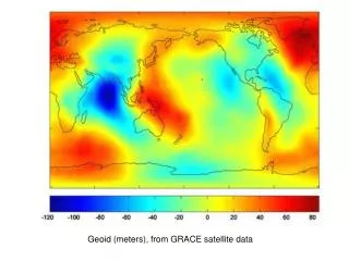
Geoid improvement over Alaska/Yukon area by GRACE and GOCE models. X Li 1 , JL Huang 2 , YM Wang 3 , M Véronneau 2 , D Roman 3 1 ERT Inc USA 2 Geodetic Survey Division, CCRS, NRCan, Canada 3 National Geodetic Survey, NOAA, USA

E N D
Geoid improvement over Alaska/Yukon area by GRACE and GOCE models X Li1, JL Huang2, YM Wang3, M Véronneau2, D Roman3 1ERT Inc USA 2Geodetic Survey Division, CCRS, NRCan, Canada 3National Geodetic Survey, NOAA, USA European Geosciences Union, General Assembly 2012Vienna | Austria | 22 – 27 April 2012
Outline Objectives Data sets used GRACE/GOCE gravity models comparison with GPS/leveling data in Alaska/Yukon area Improvement in local geoid computation by combing surface gravity data Conclusions
To assess the improvement of GRACE/GOCE satellite gravity models over EGM08 in the Alaska/Yukon area • To examine the improvement of GRACE/GOCE satellite gravity models in local geoid computation based on the method of remove-restore and kernel modification Objectives
Surface gravity data: 544,957 • 457,477(NGS)+74,933(GSD)+12,547(NGA) • 3,265,928 (DNSC08) altimetric gravity anomaly • 95 and 90 GPS/leveling data in Alaska and Yukon, respectively • Sea surface topography model from Foreman et al 2008 • Global gravity models used: • TIM (Time-wise solution GO_CONS_GCF_2_TIM_R3) • DIR (Direct solution GO_CONS_GCF_2_DIR_R3) • GOCO02s • EIGEN_6c • EGM08 • CGG10 (Canada) Data used
To avoid leakage of high frequency, only combined models (cut/paste) used GRACE/GOCE gravity models comparison with GPS/leveling data where
Local Geoid (Stokes-Helmert Method) Geoid height: Helmert co-geoid height: Low-degree components: Modification of the Degree-Banded Stokes kernel:
Weight function and its spectral Modification coefficients (Huang and Véronneau 2012) : L=150 LE=L-u/2 Spectral transfer functions: Truncation error coefficients:
GPS/Levelling Test 1 93 GPS and leveling stations 90 GPS and leveling stations
Conclusions (1) There is no noticeable improvement in GPS/leveling comparisons in Alaska (crustal motion, subsidence, PGR. etc.) . GPS/leveling (Yukon) comparison shows the improvement of satellite models over EGM08 happens between degree 80 to 195. 3 cm (21 to 18 cm) improvement of EIGEN_6c over EGM08 is seen at degree 195. There is no improvement after degree 1000. EGM08 does not improve after degree 1000, too.
Conclusions (2) GOCO02s seems more accurate than other solutions between degree 130 to 195. Coefficients of all satellite models after degree 195 seem to degrade significantly and are not useable Altimetric geoid comparisons show the improvement between degree 105 to 160. Local geoid comparisons show a similar pattern