Download

1 / 16
160 likes | 304 Views
Mission and Science Support. Presented by Timothy J. Schmit. Requirement, Science, and Benefit. Mission Goals Develops ship, aircraft, and satellite systems that ensure continuous observation of critical environmental conditions. Four key areas guide Research.

E N D
Mission and Science Support Presented by Timothy J. Schmit
Requirement, Science, and Benefit Mission Goals Develops ship, aircraft, and satellite systems that ensure continuous observation of critical environmental conditions. Four key areas guide Research. • Advancing space-based data collection capabilities and associated platforms and systems • Advancing in situ and surface-based data collection capabilities and associated platforms and systems • Overall observing systems architecture design • Data management, associated visualization technology and models, and related high performance computing and communication Science • What is the best way to undertake cal/val, full data assimilation (both ocean & atmosphere), full integration and optimization with full observations? Benefits Support society benefits areas • Improve Weather Forecasting • Reduce Loss of Life and Property from Disasters • Protect and Monitor Our Ocean Resource • Understand, Assess, Predict, Mitigate, & Adapt to Climate Variability and Change • Support Sustainable Agriculture and Forestry and Combat Land Degradation • Understand the Effect of Environmental Factors on Human Health and Well-Being • Develop the Capacity to Make Ecological Forecasts • Protect and Monitor Water Resources and Monitor and Manage Energy Resources
Challenges and Path Forward • Science challenges • Increasing numbers and complexity of sensors • Accessing the many needed data streams, including historical cases. • Keeping abreast of all relevant planned missions, especially international ones. • Demonstrate how satellites are the backbone of today’s observations system. • Next steps • Mission planning for a wide range of missions • Calibration and validation for many instruments • Data assimilation for into both atmospheric and oceanographic models • Education/Training for a wide range of missions/instruments • Transition Path • Work with many (NOAA, inter-agency and international) systems to further the mission goals • Work with a host of future systems
Outline • Mission and Science Support Goals: Continuity of Satellite Observations • Assess current conditions and predict future changes, and to understand long-term changes in the environment. • Transfer satellite observations of the land, atmosphere, ocean, and climate from scientific research and development into routine operations. Products and Services Improvement • Offer state-of-the-art data, products and services to decision-makers. • Develop a diverse spectrum of environmental algorithms and software systems. These systems are developed through extensive research programs, and transitioned from research to operations when a sufficient level of maturity and end-user acceptance is achieved. • NOAA • Inter-agency assets (NASA, DoD, etc.) • International • Summary
STAR support: From research to operations • STAR participates in the life cycle of all operational NOAA satellites from beginning to end. • STAR works with non-NOAA satellites, to transfer capabilities into NOAA, and to augment the data streams that NOAA manages. • Continuous cal/val is also performed. Science support does not stop after operational transition.
STAR Life Cycle Development STAR is where satellite data is transformed into useful environmental information
Satellite engagement categories • To further the mission goals, STAR uses NOAA operational satellites, Inter-agency satellites (including research satellites) and a plethora of international satellites.
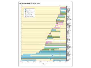
NOAA Operational: Geostationary(mid-2010) GOES-13 (75W) GOES-11 (135W) Operational Operational STAR is involved from end-to-end in each of these sensors/satellites. GOES-14 (105W) In-orbit Back-up GOES-15 (105W) Testing GOES-12 (60W) South America
GOES-R series GOES-R series is a follow-on to the existing line of NOAA’s geostationary satellites GOES-R Instruments: Advanced Baseline Imager (ABI) - Geostationary Lightning Mapper (GLM) Extreme Ultra Violet and X-Ray Irradiance Sensors (EXIS) Solar Ultra Violet Imager (SUVI) - Space Environment In-Situ Suite (SEISS) STAR is especially active with the ABI on GOES-R. Yet, STAR is also active with the GLM. AMS GOES-R Program Overview - January 2009
Current NOAA and Inter-agency: LEO NOAA Polar-orbiting Operational Environmental Satellites (POES) • AVHRR, HIRS, AMSU, etc. Jason-2/Ocean Surface Topography Mission (OSTM) • Joint NOAA, NASA, CNES, EUMETSAT effort • provides sea surface heights for determining ocean circulation, climate change and sea-level rise Defense Meteorological Satellite Program (DMSP) Inter-agency NASA • Terra, Aqua, Aura, CloudSat, CALIPSO, GRACE, ICESat, Operation Ice Bridge, EO-1, Jason-1, etc. Defense Meteorological Satellite Program (DMSP) Navy (HICO (on the ISS) USGS (Landsat)
Future NOAA and Inter-agency: LEO NOAA National Polar-orbiting Operational Environmental Satellites System (NPOESS) • VIIRS, CrIS, ATMS, CERES, OMPS-N, SEM, CMIS, etc. Jason-3 • Joint NOAA, EUMETSAT, CNES, and NASA effort Defense Meteorological Satellite Program (DMSP) Inter-agency NASA • LDCM, GPM, SMAP, ICESat-II, GLORY, AQUARIUS, NPP, CLARREO, etc. • GEO-CAPE, ACE, SWOT, GRACE-II, DESDynI, et al. Defense Meteorological Satellite Program (DMSP)
International: Current • Europe (MetOp, MSG, GOCE, ERS-2, ENVISAT, Jason-1/2, etc.) • Japan (MTSAT, PALSAR, etc.) • China (FY2 series, FY3 series) • India (Kalpana, Oceansat-2) • Canada (RADARSAT, etc.) A host of international satellite are used within STAR. The various uses include inter-calibration, product generation or as path-finder for future missions.
International: Future • Europe ((MTG:Advanced imaging, lightning, advanced geo sounding), UVN, MetOp-2, Sentinel, Jason-3, Cryosat-2, AltiKa, etc.) • Japan (MTSAT-2, GCOM, etc.) • China (FY3, FY4, HY series) • India (Imagery, INSAT-3D, AltiKa, etc.) • Russia (ELECTRO-L) • Korea (Coastal Waters, COMS, COMS-2) • Canada (PCW, RCM, etc.) • Brazil STAR will continue to use the many improvements in the observation of our international partners.
Sample Uses by instrumentSTAR uses many satellite assets… GOES Imager SeaWIFS ENVISAT GOES Sounder IASI AIRS SEVIRI TES MTSAT ASCAT OSIRIS AMSU MLS TRMM Jason 2 OMI/TOMS/GOME-2 AVHRR MODIS SCIAMACHY MERIS CALIPSO/CloudSat Many other products are researched, generated and/or validated by STAR and it’s partners. Of course each satellite actually has dozens of products.
Challenges and Path Forward • Science challenges • Increasing numbers and complexity of sensors • Accessing the many needed data streams, including historical cases. • Keeping abreast of all relevant planned missions, especially international ones. • Demonstrate how satellites are the backbone of today’s observations system. • Next steps • Mission planning for a wide range of missions • Calibration and validation for many instruments • Data assimilation for into both atmospheric and oceanographic models • Education/Training for a wide range of missions/instruments • Transition Path • Work with many (NOAA, inter-agency and international) systems to further the mission goals • Work with a host of future systems
Session Lead-in ✔ • What follows are specific examples of scientific support STAR provides for mission support • GOES-R • NPOESS • Jason-2 & Jason-3 Altimetry Missions • Calibration / Validation • Satellite Data Assimilation