Download
1 / 22
220 likes | 326 Views
Collaborative Integration of Satellite and Surface Data for Characterization of Aerosol Events. E. M. Robinson Advisor, R. B. Husar 2010 M.S. Thesis St. Louis, MO, Nov. 3, 2010. Satellite-Integral. Illustrate the use of multi-sensory data. Technical Challenge: Characterization

E N D
Collaborative Integration of Satellite and Surface Data for Characterization of Aerosol Events E. M. Robinson Advisor, R. B. Husar 2010 M.S. Thesis St. Louis, MO, Nov. 3, 2010
Satellite-Integral Illustrate the use of multi-sensory data Technical Challenge: Characterization • PM characterization requires many sensors, sampling methods and analysis tools • Each sensor/method covers only a fraction of the 7-Dimensional PM data space. • Spatial dimensions (X, Y, Z) • Temporal Dimensions (T) • Particle size (D) • Particle Composition ( C ) • Particle Shape (S) • Most of the 7 Dim PM data space is extrapolated from sparse measured data • Others sensors integrate over time, space, chemistry, size etc. . Satellites, have high spatial resolution but integrate over height H, size D, composition C, particle shape
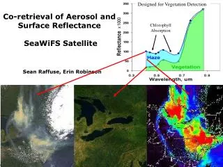
Kansas Agricultural Smoke, April 12, 2003 Organics 35 ug/m3 max Fire Pixels PM25 Mass, FRM 65 ug/m3 max Ag Fires SeaWiFS, Refl SeaWiFS, AOT Col AOT Blue
Hurdles “The user cannot find the data; If he can find it, cannot access it; If he can access it, ; he doesn't know how good they are; if he finds them good, he can not merge them with other data” The Users View of IT, NAS 1989 To overcome the first two hurdles need: • Service oriented architecture • Standards for finding and accessing the data • Open, collaborative space to coordinate work
SOA Actions Actions:Register– Discover-Access User Provider Broker The data reuse is possible through the service oriented architecture of GEOSS.
SOA Actions Actions:Register– Discover-Access Broker User Provider The data reuse is possible through the service oriented architecture of GEOSS.
Preparation of Data and Metadata GEOSS Clearinghouse Access Provider User Data Protocol WMS, WCS (netDCF CF) + conventions Data Metadata
Preparation of Data and Metadata GEOSS Clearinghouse Register Metadata Provider User Data Protocol WMS, WCS (netDCF CF) + conventions Metadata ISO 19115 subset for Geospatial Data Data Metadata
Air Quality Metadata Record GEOSS Clearinghouse Discover, Get Access Key Provider User Metadata for Finding and Accessing Data Data Binding Air Quality Specific OGC CSW Queryable OGC CSW Returnable Metadata Description ISO 19115CSW Profile
Exceptional Event Rule:An air quality exceedance that would not have occurred but for the presence of a natural event. Transported Pollution Transported African, Asian Dust; Smoke from Mexican fires & Mining dust, Ag. Emissions Natural Events Nat. Disasters.; High Wind Events; Wild land Fires; Stratospheric Ozone; Prescribed Fires Human Activities Chemical Spills; Industrial Accidents; July 4th; Structural Fires; Terrorist Attack Satellite remote sensors provide key observations for Exceptional Events
May 2007 Georgia FiresAn actual Exceptional Event Analysis for EPA May 5, 2007 May 12, 2007 Observations Used:
OMI NO2 Quantifies the NO2 Emission Sweat Water fire in S. Georgia (May 2007)
3. Evidence: Aerosol Composition Sulfate Organics Measured Sulfate Organics Modeled
5. The Exceedance would not Occur, But For the Exceptional Event
SOA Actions Actions:Register– Discover-Access Broker User Provider The data reuse is possible through the service oriented architecture of GEOSS.
Social Media Listening for Air Quality RSS Feeds Air Twitter Aggregator Air Twitter Filter ESIPAQWG
Air Twitter – Event Identification August 2009, Los Angeles Fires Normal Weekly Trend
Air Quality EventSpaces EventSpaces are community workspaces on the ESIP wiki that are created to describe the Event Science Data Social Media