Download
1 / 10
100 likes | 124 Views
Explore real-time data assimilation during COPS workshop. Observations like GPS and lidar data are included. Learn about the status, conclusions, and action items discussed at the 5th COPS Workshop in Hohenheim.

E N D
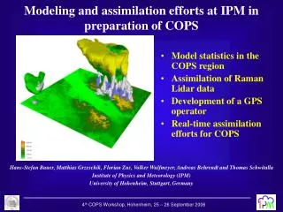
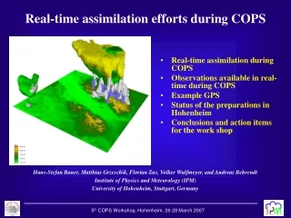
Real-time assimilation efforts during COPS • Real-time assimilation during COPS • Observations available in real-time during COPS • Example GPS • Status of the preparations in Hohenheim • Conclusions and action items for the work shop Hans-Stefan Bauer, Matthias Grzeschik, Florian Zus, Volker Wulfmeyer, and Andreas Behrendt Institute of Physics and Meteorology (IPM) University of Hohenheim, Stuttgart, Germany 5th COPS Workshop, Hohenheim, 26-28 March 2007
Real-time assimilation of COPS data • Real-time assimilation during COPS is done operationally in a region including the COPS domain by: • Meteo-France (ALADIN with 9.5 km, and AROME with 2.5 km) • Meteo-Swiss (COSMOCH7 with 7 km, and COSMOCH2 with 2km) • DWD (COSMO with 2.8 km) • Depending on the data provided during COPS, DWD will set up an extra assimilation with the COSMO model in an experimental mode. • IPM UHOH will set up an experimental real-time data assimilation using the MM5 4DVAR system. It will be set up for COPS. Therefore, the assimilation of additional data collected during COPS (mainly GPS slant-path and lidar data) is planned. Here, additional data from COPS will only be included if the data type is already used operationally, and provided operationally to the forecasting center. Real-time assimilation during COPS Real-time assimilation during COPS 5th COPS Workshop, Hohenheim, 26-28 March 2007
Observing groups Weather service Model & Data Prepare observations using one accepted data format (e.g. NetCDF). Store data used for real-time assimilation Put the data into the GTS system so that it is available for the assimilation. Fixed accepted location (e.g. hard disk in Hamburg) Observations available in real time Here, many open questions exist, which have to be discussed at the workshop. • What data is available for real-time assimilation? • GPS, wind lidar, additional sounding, and surface data • ground-based and airborne lidar data, … • It is important that responsibilities are shared between the groups. • It is necessary that the data format and the operational schedules are fixed as soon as possible. 5th COPS Workshop, Hohenheim, 26-28 March 2007
Stations so far used for the assimilation (UHOH) Filled circles: fixed or permanent GPS stations Open blue circles: additional French stations shall form a transect for tomography between supersites Open yellow circles: additional German stations of GFZ as of 4th COPS Workshop located at COPS supersites Coordination: Cedric Champollion, Galina Dick Example: GPS Network 5th COPS Workshop, Hohenheim, 26-28 March 2007
UHOH assimilation cycle during COPS Parallel forecast without additional data 5th COPS Workshop, Hohenheim, 26-28 March 2007
Real-Time Assimilation System MM5 set up • 18km horizontal resolution for the assimilation • 36 vertical layers • 6-h assimilation window • Free forecasts in 3 two-way interacting nests with 18, 6, and 2 km horizontal resolutions. 5th COPS Workshop, Hohenheim, 26-28 March 2007
Status plot generation • The plots from the participating models necessary for mission planning will be generated by one system to ensure cross-model comparability. • The system is based on the visualization tool GrADS, and its development is coordinated in Hohenheim (Matthias Grzeschik). • Starting from TIGGE+ conform model output, several „standard plots“ necessary for the forecaster are generated automatically. 5th COPS Workshop, Hohenheim, 26-28 March 2007
Action items for the workshop • Confirmation of interested groups (observations and assimilation) • Distribution of responsibilities • Data format, data handling, and data flow for real-time purposes • Operational schedule • Forecasting centers • Observations • Mission planning Conclusions • COPS provides a unique data set for real-time data assimilation. • Assimilation of data from sophisticated water vapor observing systems like DIAL, Raman lidar, and GPS proved to impact the forecasts. However, single case studies do not allow general conclusions about the potential of these observing systems. • Therefore, real-time assimilation of data provided additionally to already oper- ationally used data during COPS is an important task and a great opportunity. 5th COPS Workshop, Hohenheim, 26-28 March 2007
ECMWF assimilation cycle 5th COPS Workshop, Hohenheim, 26-28 March 2007