Download
1 / 30
390 likes | 716 Views
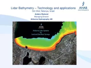
Lidar Bathymetry – Technology and applications Oct 24rd, Netanya, Israel. Anders Ekelund Managing Director Airborne Hydrography AB. Airborne Hydrography AB. World recognized supplier of Airborne LIDAR systems Products HawkEye II for bathymetry Chiroptera for shallow water

E N D
Lidar Bathymetry – Technology and applicationsOct 24rd, Netanya, Israel Anders Ekelund Managing Director Airborne Hydrography AB
Airborne Hydrography AB World recognized supplier of Airborne LIDAR systems Products • HawkEye II for bathymetry • Chiroptera for shallow water • DragonEye for land Privately owned Airborne Hydrograpy was formed in a buyout from SAAB AB, and has accumulated more than 25 years of bathymetric LiDAR product development for SAAB and the Swedish Navy
Products 3 • HawkEye II • An airborne coastal survey system including deep water bathymetry and topographic LIDAR • Chiroptera • A shallow water coastal survey system including high density bathymetric LIDAR and high end topographic LIDAR • DragonEye • A high end pure topographic LIDAR system
LIDAR Bathymetry - What’s the Attraction? LiDAR Bathymetry is very cost efficient tool for large scale digital elevation modelling projects in the coastal zone Area coverage 10-50 km2 per hour The advantages of LIDAR bathymetry - Delivers data from both land and sea/floor - Fast progress (typical 10-50 Square km / hour) - No hazard for survey ships - Delivers the accuracy the authorities need
Batmetric LIDAR • Typical end products • X,Y, Z point clouds (bathymetric and topographic) • Digital Elevation Models • Bathymetric charts, X,Y depths created from HawkEye data and tidal model • Shoreline definition • Image orthomosaics • Sea-bed reflectance product • Additional environmental products
Sea-mine detection • Dummy sea-mine • 70 cm diameter water filled boat fender, • painted in NATO green according to Ministry of Defence standard 00-23, Issue 3, may 30m 2001. • Anchored on about 2,5 meters depth, at about 5,5 meters water depth.
Sea-mine detection • The sea-mine is clearly visible in between the sea-surface and sea-bed
Natural target at sea-floor • Blue - Multibeam data • Green - LIDAR data • 0.8 meter high bolder found in both multibeam and LIDAR dataset
Man made target • Blue - Multibeam data, • Green - LIDAR data • A one meter high cube placed on the sea-floor after the multibeam survey, discovered by the LIDAR
Sample data28 meter high object on the surface, 4,4 meters depth belowWhat’s that?
SummaryModern bathymetric LIDAR • Simultanious capture of topo and bathy • Full waveform in both topo and bathy • Reasonable depth penetration • > 20 meter in clear waters k=0,1 • > 10 meters in less clear water k=0,2 • Capture of small targets • IHO special order objects detected to about 2/3 of the depth penetration • Excellent accuray • Bathymetry close to IHO special order (25 cm, 2 sigma, absolute)
SummaryModern bathymetric LIDAR • High data density • Typical • Topo > 10 points per square meter • Bathy > 1 point per square meter • Easy installation • Sensor weight: 80 Kg • Power consumption: 15 Amp on the 28 VDC supply • One single turn key unit • Simple touch sceen operators interface
SummaryModern bathymetric LIDAR • Can be used for a large number of appliacations • Coastal monitoring • Sea-Charting • Environmental monitoring • Oil and Gas Pipelines • Ports, harbours • River survey • Object (sea-mine detection) • Sea-bed classification • Military applications