Download
1 / 11
130 likes | 298 Views
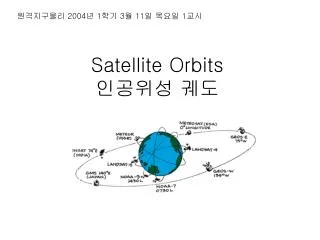
원격지구물리 2004 년 1 학기 3 월 11 일 목요일 1 교시. Satellite Orbits 인공위성 궤도. Launch Animation. NASA server. KNU Server: no sound but storable. Close to Earth (320~800km) ~27,000 km/h 90min period Space Shuttle Some Remote Sensing Satellites and weather satellites

E N D
원격지구물리 2004년 1학기 3월 11일 목요일 1교시 Satellite Orbits인공위성 궤도
Launch Animation NASA server KNU Server: no sound but storable
Close to Earth (320~800km) ~27,000 km/h 90min period Space Shuttle Some Remote Sensing Satellites and weather satellites ~8,000 Space Junks – satellites, old rockets, metals, etc. Low Earth Orbits저궤도
Polar Orbit극궤도 • One type of LEO • High inclination • Can scan the entire surface due to earth rotation (east-west) and satellite orbit (north-south) • Most remote sensing satellites and some weather satellites
Sun-synchronous Orbit • These orbits allows a satellite to pass over a section of the Earth at the same time of day. • Since there are 365 days in a year and 360 degrees in a circle, it means that the satellite has to shift its orbit by approximately one degree per day. • These satellites orbit at an altitude between 700 to 800 km. • These satellites use the fact since the Earth is not perfectly round (the Earth bulges in the center, the bulge near the equator will cause additional gravitational forces to act on the satellite. • This causes the satellite's orbit to either proceed or recede. • These orbits are used for satellites that need a constant amount of sunlight. • Satellites that take pictures of the Earth would work best with bright sunlight, while satellites that measure longwave radiation would work best in complete darkness.
Satellite is always at the same position w.r.t the rotating earth Altitude: 35790km exactly T=23hrs 56min 4.09sec ‘Big-picture view’ Broadcast or Communication satellites Orbit plane = Earth rotation plane Geosynchronous Orbit지구정지궤도
Perigee(closest), Apogee(farthest) Period: ~12hrs Polar coverage Ccommunication satellites for north and south region Apogee Perigee Elliptical Orbit타원궤도
Orbit Size and Shape Parameter Definition • Semimajor Axis: Half the distance between the two points in the orbit that are farthest apart • Apogee/Perigee Radius: Measured from the center of the Earth to the points of maximum and minimum radius in the orbit • Apogee/Perigee Altitude: Measured from the "surface" of the Earth (a theoretical sphere with a radius equal to the equatorial radius of the Earth) to the points of maximum and minimum radius in the orbit • Period: The duration of one orbit, based on assumed two-body motion • Mean Motion: The number of orbits per solar day (86,400 sec/24 hour), based on assumed two-body motion • Eccentricity: The shape of the ellipse comprising the orbit, ranging between a perfect circle (eccentricity = 0) and a parabola (eccentricity = 1)
Universal Law of Gravitation = Centripetal Force Orbit Period • T is proportional to r • T only depending on the mass of the central body • It holds for elliptical orbit when r is a, the semi-major axis of the ellipse. • is constant for every satellites
Parameter Definition Inclination: The angle between the orbital plane and the Earth's equatorial plane (commonly used as a reference plane for Earth satellites) Right Ascension of the Ascending Node: The angle in the Earth's equatorial plane measured eastward from the vernal equinox to the ascending node of the orbit Argument of Perigee: The angle, in the plane of the satellite's orbit, between the ascending node and the perigee of the orbit, measured in the direction of the satellite's motion Longitude of the Ascending Node: The Earth-fixed longitude of the ascending node Orbit Orientation
Satellite Location Parameter Definition • True Anomaly: The angle from the eccentricity vector (points toward perigee) to the satellite position vector, measured in the direction of satellite motion and in the orbit plane. • Mean Anomaly: The angle from the eccentricity vector to a position vector where the satellite would be if it were always moving at its angular rate. • Eccentric Anomaly: An angle measured with an origin at the center of an ellipse from the direction of perigee to a point on a circumscribing circle from which a line perpendicular to the semimajor axis intersects the position of the satellite on the ellipse. • Argument of Latitude: The sum of the True Anomaly and the Argument of Perigee. • Time Past Ascending Node: The elapsed time since the last ascending node crossing. • Time Past Perigee: The elapsed time since last perigee passage.