Download
1 / 10
100 likes | 224 Views
Data needs & mapping the non-carbon benefits of REDD+ Land Cover Symposium June 2013 Niklas Hagelberg, UNEP. REDD+ and Multiple Benefits . When forests are retained or restored through REDD+ , they deliver additional benefits to protecting or enhancing carbon stocks .

E N D
Data needs & mapping the non-carbon benefits of REDD+ Land Cover Symposium June 2013 Niklas Hagelberg, UNEP
REDD+ and Multiple Benefits • When forests are retained or restored through REDD+, they deliver additional benefits to protecting or enhancing carbon stocks. • Types of multiple benefits • Ecosystem services • Biodiversity conservation • Livelihood and social benefits • Why map multiple benefits? • Biodiversity and ecosystem services are spread unevenly across space • Spatially explicit data can help identify areas of importance for multiple benefits • Monitoring of impacts of REDD+ decisions (safeguards)
Multiple benefits mapping: Nigeria Carbon and Biodiversity Density of existing carbon stocks (brown) Important Bird Areas (green) Gorilla ranges (orange) Chimpanzee ranges (yellow)
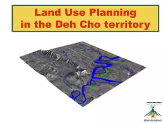
Multiple benefits mapping: Tanzania Where are major wildlife corridors located and how do they correspond with natural forest, carbon stocks and areas under protection? Map sources: Biomass: NAFORMA woody biomass only. 5km preliminary datset base on field data only. Natural forest: NAFORMA landuselandcover map 2010. Wildlife corridors based on information provided at tzwildlifecorridors.org Protected Areas and Forest Reserves: TFS and WDPA 2013.
Multiple benefits mapping: Tanzania Where has harvesting of non-timber forest products been observed? Example: Households that use food from the forest Map sources: Natural forest: NAFORMA landuselandcover map 2010. Biomass: NAFORMA woody biomass only. 5km preliminary datset base on field data only. NTFPs, NAFORMA 2013.
Spatial decision support software for land-use planning • Countries face complex challenges when designing REDD+ land-use plans • REDD+ strategies must take into account other pressures, e.g. urban expansion/ agricultural development /mineral extraction • Where and how REDD+ is implemented has the potential to increase multiple benefits, or create a risk to them • Computer programmes (software) can be used to support the land-use planning process
E.g. Using Marxan for REDD+ • Marxan is a type of spatial decision support software • Marxan can be used to demonstrate where priority areas for REDD+ interventions should be when there are too many considerations for the solution to be obvious. • This map of DRC illustrates the overlap between great ape ranges, IBAs and carbon: Marxan can take it a step further: • Deforestation trends & valuation • Marxan can seek to preserve from this map 50% of Great ape ranges and 5Gt of carbon • Even with just 2 objectives, this would be difficult for a human to analyse all of these options and present the optimum one
Other data needs Social data, e.g.: • Poverty data • Population density • Children/youth as a % of the total population • Percentage of population employed in forestry/ farming/ agricultural sectors • Indigenous territories • Distribution of communities leading traditional lifestyles However, much of this social data doesn’t exist/ and/or is not available in a spatial format
Global Forest Watch 2.0 • Builds on DETER • MODIS & Landsat • Identification/alerts of deforestation hotspots • Combined with mobile apps & social media • Supply chains • WWW.GFW-BETA.ORG
Niklas Hagelberg niklas.hagelberg@unep.org Thank You Website: http://www.un-redd.org