Download
1 / 14
140 likes | 300 Views
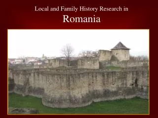
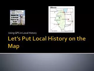
Using GPS in Local History. Let’s Put Local History on the Map. Research your historic site. Using the Manito History Books, Research information on a historic site in Manito Find a picture of the historic location and scan it into a file and print.

E N D
Using GPS in Local History Let’s Put Local History on the Map
Research your historic site • Using the Manito History Books, Research information on a historic site in Manito • Find a picture of the historic location and scan it into a file and print. • Write a brief history of that historic site (building), • Cite: Works Cited Page • Manito Historical Society, comp. Manito Illinois Celebrating 150 Years 1858-2008. Rich Hill, MO: Bell, • 2008. Print. • Manito Historical Society, comp. Manito Illinois It’s Good to Remember. Manito, IL: Self Published, • 1983. Print. • Word Process the information and attach the picture you scanned and print. Save information on your student drive. • Create a treasure hunt clue for your historic site for the fifth graders. (Use pictures, written hints and lat/longitude info.)
GPS & GeoCaching- Authentically Engaging Curriculum Contact| Projects | Help Home / GPS & Geocaching Home /Why it Works with Students / GPS Basics GPS basic info GPS activities GeoCaching basic infoSample Projects Ed Theory & GPS Contact Us Earth Caching Earth Caching info Earth Cache locations Sample Earth Caches Create an Earth Cache Travel Bug Tracking What is a travel bug? Create a travel bug Tracking Travel bugs Travel Bug WebQuestSchool Travel Bug GPS is highly motivating for students! GPS Basics! GPS units- resources for learning how to use a GPS unit. GPS units help measure exact location on the Earth's surface as well as direction of travel, rate of travel and other information!
On the site: • Take a picture of the current site using digital camera or phone. Take a picture of a unique feature to possibly use for treasure hunt clue. • Enter the GPS way point and find the latitude and longitude of your site. • Why Make an Eco Cache? • Give a location in your area a voice as well as making your mark on the world for your community! • All you need to get started is something to share locally and a GPS receiver.
Back at School: • Enter EcoCacheinformation on handout. • Enter information on line for world wide access. • http://www.ilega.org/ecocaches/ecocaches.htm • EcoCache is an educational virtual geocache that people can visit to view an unique feature. EcoCaching is the concept of treasure hunting for caches that the Earth has stored.
EcoCache • Why Make an EcoCache? • Give a location in your area a voice as well as making your mark on the world for your community! • All you need to get started is something to share locally and a GPS receiver.
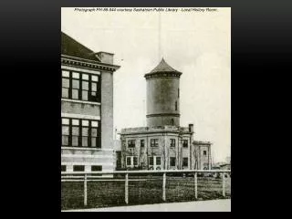
Illinois EcoCache • Manito Opera House - Precinct Building Manito, IL • Brief Description: • Manito Opera House - Precinct Building • Location: • In the village of Manito, Illinois • Latitude / Longitude • N 40° 25.442 • W 089° 46.238 • EcoCache ID: • 17125004 • Difficulty: • 1 out of 5 • Terrain: • 1 out of 5 • Submitting Group: • Midwest Central High School - Teresa Heinhorst Website: • www.midwestcentral.orgDate Submitted • 03/24/2011Significance • One of the historic sites of Manito, Il which was one of the main entertainment sources for the community. • Long Description • The Manito opera house was constructed in 1899. It was at the site of what is now the park on Washington Street. Wood was used to build the building inside and out. The ground floor of the building was used for local entertainment and plays. In 1962 it started falling apart at the end of that year Robert Bailey of Havana purchased the building for $350 and his crews began to tear down almost immediately. When they started tear it down they found that some other things took up residents there also, there was a swarm of bees and about 100 pounds of honey. After the Opera house was torn down in 1962 there was a precinct building where Manito residents voted until the new village hall was built. • Pictures: • Picture 1 • Picture 2 • Picture 3 • Picture 4
In the Newspaper • MCHS Students Use GPS in Local History • The World History students at Midwest Central High School have been learning how to use and incorporate GPS (Global Positioning System) technology to put local history on the map. The students had to research the history of locations in Manito using the old and new Manito History books; they had to find pictures of the old historic site and using a digital camera take a current picture of these sites. The students used the GPS units to find the exact latitude and longitude location and made a waypoint. They used all this information to input into the Illinois Educational Geocaching Association website which will enable anyone to locate our historic sites in Mason County. These sites are ecocaches which is similar to geocaches. Ecocaches are any places where a natural or cultural feature can be found on the landscape such as historic buildings, and cemeteries. Geocaching is hiding of treasures (or a cache) in a location using the GPS device to find the cache. To find Manito ecocaches you can check out the website http://www.ilega.org/ecocaches/illinoismap/Illinoismap.htm. Click on Mason County and you should see several locations our students have been working on. We have also used this information in conjunction with the Manito Historical Society to create a treasure hunt to historic locations in Manito for the Midwest Central fifth graders. This project has allowed us to assist in the development of a historic map of the area that integrates student work with that done by members of the Manito Historical Society. This community to school project has been both an educational and rewarding project.
Community to School • Part of this project is in conjunction with the Manito Historical Society- Research information of historical sites, vintage pictures of the locations and the last part of the project which is providing education of local history to our Midwest Central fifth graders.
Fifth grade Treasure hunt • The students created 5 different clues for the students to locate their historic sites one including the use of GPS technology.
Fifth Grade Field Trip • World History Students will accompany the fifth graders on their treasure hunt to help them with the use of the GPS units and to answer any questions. • The high school students have other roles during the last part of the field trip. • Some students will be helping teach in the old red school. • Some students will act as the prisoners in the Old jail and have to learn and tell the story of the real crime in Manito they committed while in Character. • Other students will dress , act, and give their short life story as a person buried in Oak Grove Cemetery. Ex. (Civil War Veteran) • Other students will help fifth graders to learn to do a cemetery rubbing.
Geocaches in Manito http://www.geocaching.com/seek/cache_details.aspx?guid=235f0c85-fdac-40fc-b89f-27dd05794227