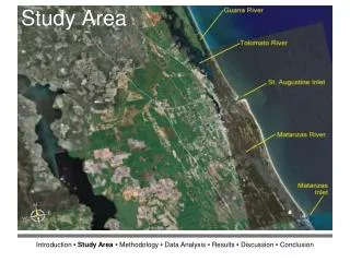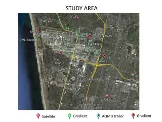
Study Area
Site Suitability Analysis for a Central Wastewater Treatment Plant (S ) In Accra Metropolitan Area Using Geographic Information System


Study Area
E N D
Presentation Transcript
Site Suitability Analysis for a Central Wastewater Treatment Plant(S) In Accra Metropolitan Area Using Geographic Information System Paulina Ansaa Asante (paulina.asante1989@gmail.com)Alex OwusuBarimah(owusuba@yahoo.com)Remote Sensing and GIS Laboratory Department of Geography and Resource Development, University of Ghana, Legon
This study presents the use of Geographic Information Systems (GIS) in selecting suitable sites for the construction of a central wastewater treatment plant(s) • For this purpose, several variables were analyzed using GIS technology. • This method present here, can also be used in checking the suitability of selected sites or new areas for the purpose of constructing wastewater treatment plants.
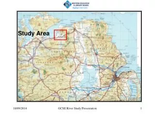
Study Area • The study was conducted in the Accra Metropolitan Area (AMA) • AMA is a primate city in Ghana with a total land surface area of approximately 231km2 • Has a total population of 3.9 million, population density 69.3 persons per hectare and growth rate of 3.36% (GaWC, 2010) • It lacks of wastewater treatment facilities • The study was to help solve the problem of siting wastewater treatment plants
A Suitable Location • Is not likely to pose any health threat to the environment as well as the people. • Large enough for locating central wastewater treatment plant(s). • Accessible • No negative aesthetic effect to the city • Gain the support of the people
Objectives. The study also considered the following sub objectives. • Ascertain the factors that are considered in selecting a site. • Determine what would be the best site(s) based on multi-criteria decision making algorithm • Examine the attitude, knowledge and perceptions of residents on wastewater treatment plants
Methodology: • The study was approached in two ways. • 1. stakeholder interviews and criteria assessment to identify common criteria that need to be considered in suitable site selection. • 2. the application of GIS (multi-criteria decision making) in modelling these factors in order to arrive at locations that are suitable for locating wastewater treatment plants. The result is a composite map, which highlights the areas that satisfy all suitability criteria. ArcGIS software was used
Multi-criteria decision making Variable and Criteria The process was divided into two steps, A. Selection of variables and criteria with stakeholders; Key variables include • slope, • land cover, • distance to existing major roads, • distance to rivers and lagoon, • distance to existing major populated communities and • distance to airport facilities.
Multi-criteria decision making Variable and Criteria • the second step looked at the actual analysis using variables and criteria to determining suitable and not suitable locations • The final analysis of each variable was used to create maps showing only the areas of interest. • The study applies exclusionary criteria.
Methodology: Slope • Mild slopes would result in, higher hydraulic residence times and thus higher pollutant removal capacity. • To minimize pumping costs and improve the overall efficiency of the wastewater treatment plant a maximum slope value of 10% was considered based on officials guidelines.
Methodology: Analyzing the Variables Having examined all the different variables in the study area and maps created for each based on criteria identified, The final analysis was carried out using the overlay function in ArcMap provided by the ArcGIS program. The result is showing the areas that meet all the previously specified criteria and are suitable for the construction of a central wastewater treatment plant in the Accra Metropolitan Area.
Selected Areas for Central Wastewater Treatment Plant in AMA
Major Findings • The total land area of AMA suitable for central wastewater treatment plant is about 20km2. • This is the parcel of land north of AMA • Most residents living around treatment plants have no knowledge about the essence of treatment plants. • They are indifferent
Conclusions • Any final decision at the sub-metro level should be based on more detailed examination on each selected sites, involving a ranking of all possible sites using non-exclusionary criteria. • The opinion of the people in the local communities should be taken into consideration in making the final decision to use any site for the construction of the treatment plant. • Education of the local people is also very vital as it informs them on the essence of the installation of the treatment plants and how they would have to handle them.
End Of Presentation Thank You.