Download
1 / 33
330 likes | 366 Views
Explore how India's physical geography influenced early civilization growth, from mountains dividing the region to monsoon winds vital for agriculture. Discover the impact of rivers, farming, and more in this engaging unit.

E N D
6th Grade UBD - Unit 4 - Geography of India Geography of India
Essential Question • How did physical geography shape Indiancivilization?
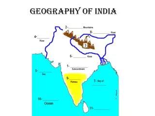
Preview • Mountains and Seas- South Asia is surrounded by two geographic features. There are mountain ranges to the north and large bodies of water to the south. • Rivers, Farming, and Civilization- South Asia gets the water it needs for agriculture from rivers and from the monsoon winds. The monsoon winds bring rain each summer. Having a steady water supply allowed early farmers to grow a steady supply of food for the people of South Asia.
Reach Into Your Background • India is surrounded by two geographic features. There are mountain ranges to the north and large bodies of water to the south. How might these geographic features influence life in India? (5 minutes)
Partner Activity • Work with a neighbor and compare your answer with theirs. What things are the same and what things are different? (3 minutes)
Key Ideas- Mountains and Seas • The Himalayas divide South Asia from Central Asia. • The mountains and ocean that surround India affect its climate. • The monsoon winds are caused by the mountains and the water surrounding India. Monsoon winds create a wet and a dry season. Monsoon winds make agriculture possible. • The mountains and ocean also separate South Asia from the rest of Asia. This has offered some protection from invaders.
Location and Geography of Asia Video- Location and Geography of Asia
Between the Mountains and the Sea • Ancient India, located in SouthAsia, was home to many early civilizations. • Ancient India included territory that makes up the modern-day countries of India, Pakistan, and Bangladesh.
Mountains • The northern boundary of India is lined with vast mountain ranges. • The tall Himalayas, which contain Mount Everest, are located in the northeastern part of India.
Mount Everest • Mount Everest, the world's tallest mountain. • The trek up the mountain involves two weeks of hiking up rough paths in increasingly higher altitudes.
Mount Everest Video- Mount Everest
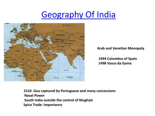
Sea • The southern portion of India is surrounded by the Bay of Bengal and the Arabian Sea. • The Arabian Sea would eventually become an important trade route between South Asia and the rest of the world.
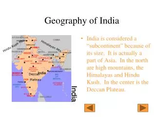
Subcontinent • Although India is part of Asia, it is geographically separated from the rest of the continent by the mountains to the north and the ocean to the south.
Subcontinent • Water and mountains surrounded ancient India. This geographic isolation protected the people who settled in this region. • It was extremely difficult for outside invaders to reach the subcontinent without making dangerous journeys over the mountains or across the ocean.
Key Ideas- Rivers, Farming, and Civilization • The Indus River and the Ganges River flow from the Himalayas to the Indian Ocean. They bring water and rich sediment to the river valleys. • The monsoon winds bring seasons of cool, dry air and warm, moist air. The monsoon rains provide most of the rainfall in South Asia. • The Indus Valley civilization was well developed. It had agriculture, advanced cities, and a written language. The Indus Valley people used technology. An example of this is advanced water drainage systems.
Rivers and River Valleys • Water is necessary for the survival of every civilization. • The two major rivers of the region are the Indus River and the Ganges River.
Rivers and River Valleys • Both the Indus and the Ganges Rivers carry minerals from the Himalayas into the valleys.
Promise and Peril • The rich plains these two rivers create made ancient India a good area for agriculture. • They also supplied water for people, plants, and animals. • This made the Indian subcontinent an ideal location for civilizations to develop.
Promise and Peril • The Indus and the Ganges presented challenges to early settlers. • The rivers flooded regularly. This would destroy many of the crops planted in the rich soil along their banks.
Weather Patterns of Asia Video- Weather Patterns of Asia
Wet and Dry • South Asia’s climate is different from the climate of the rest of Asia. • South Asia’s year is divided into two seasons. There is a warm, wet season and a cool, dry season.
The Seasons • In the winter, the monsoon winds blow from Central Asia into the Indian subcontinent. • During this time, very little rain falls over most of the Indian subcontinent.
The Seasons • In the summer, the monsoon winds change direction. • They bring warm, moist air from the Indian Ocean onto the subcontinent. • During the summer monsoon, it usually rains daily.
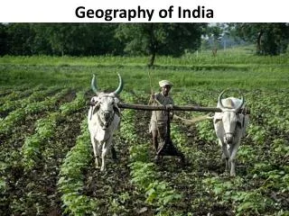
Planting Around Monsoons • Farmers in South Asia depend on the monsoon rains to provide the water they need to grow their crops. • Farmers planted in the summer months, when water was available. They harvested in the fall. If the monsoon rains were late, farmers and their crops suffered.
Civilization in the Indus Valley • Early farmers on the Indian subcontinent usually settled near rivers. • Rivers provided rich fertile soil for planting crops.
Civilization in the Indus Valley • South Asian farmers began to farm in the river valleys because of the fertile land. • They tamed animals for plowing the land and they planted crops. • They formed small farming settlements.
Civilization in the Indus Valley • These settlements were able to produce a steady food supply. They even grew a surplus of food. • A steady food supply allows people to gather in large groups and allowed people to form civilizations.
Civilization in the Indus Valley • The first civilization of ancient India rose along the Indus rivers in modern-day Pakistan. • As farmers grew a surplus of food, other workers began to specialize in occupations other than farming.
Life in Ancient India’s Major Cities • The Indus Valley civilizations that existed from about 2500 to 1700 BCE were complex. • They had written language and well-developed trade. • They had advanced knowledge of mathematics.
Math • One way the people of ancient India applied their mathematical skills was in the design of their cities, which were laid out on a grid pattern. • They used weights and measures when they traded for goods.
Rivers, Farming, and Civilization • The Indus Valley civilization was as advanced as other early civilizations, such as Mesopotamia and Egypt. • Ancient India had a system of writing, city planning that showed an understanding of mathematics, and enough natural resources to survive and grow. • The Indus Valley civilization was also located close enough to other civilizations that its people could trade for resources that they needed but did not have.
Independent Activity • What has been the “muddiest” point so far in this lesson? That is, what topic remains the least clear to you? (4 minutes)
Partner Activity • Work with a neighbor and compare your muddiest point with theirs. Compare what things are the same and what things are different? (3 minutes)