Download
1 / 65
670 likes | 1.67k Views
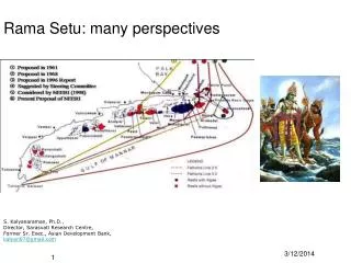
Rama Setu: many perspectives. S. Kalyanaraman, Ph.D., Director, Sarasvati Research Centre, Former Sr. Exec., Asian Development Bank, kalyan97@gmail.com. Perspectives. scientific oceanography (tsunami) historical, cartographic literary archaeological, heritage geopolitical

E N D
Rama Setu: many perspectives S. Kalyanaraman, Ph.D., Director, Sarasvati Research Centre, Former Sr. Exec., Asian Development Bank, kalyan97@gmail.com
Perspectives • scientific • oceanography (tsunami) • historical, cartographic • literary • archaeological, heritage • geopolitical • society, environment • religious, cultural • project, nautical • legal
Computer simulation: Ram Setu saved coastline from tsunami on Dec. 26, 2004
A volcanic canyon west of Rama Setu, 1 m to 3000 m slope Location map. Inset: bathymetry map of the Gulf of Mannar (reproduced from Murty et al., 1994) http://www.Setusamudram.in/htmdocs/Articles/cp_rajendran_2.htm
Canyon below the ocean?Question of stability of any channel on this slope. • Abstract Two suites of slumps from opposite margins of the Gulf of Mannar, between Sri Lanka and southern India, have met and coalesced. The “Eastern Comorin” Slump is the more coherent of the two with a length of 70 to 100 km. The “Colombo” side slump consists of two to four blocks 15 to 35 km in length. Both slump-suites decrease to the south. A paleoslump underlies the western toe of the East Comorin Slump at a depth of some 800 meters. To the south, an enlarging and deepening submarine canyon marks the area of slump coalescence.See William Vestal and Allen Lowrie, Geology and Geophysics Branch-Code 7220, U.S. Naval Oceanographic Office NSTL Station, 39522, MS • http://www.springerlink.com /content/m602j3k746342lnl/
Heatflow in Rama Setu 100 to 180 milliwatt per sq. m. comparable to Himalayan hotspringsWill dredging in the area activate these heat zones? This question has to be answered by a multi-disciplinary team.
Mannar Volcanic rocks 100 m. old in Gulf of Mannar, making Rama Setu an ancient formation
Bore-hole locations on Rama Setu Geomorphology • Consequences of dredging and opening of Rama Setu: • Likely destruction of fragile coral islands by sediments and turbulent tides of Bay of Bengal entering the tranquil Gulf of Mannar • Likely reactivation of sub-sea heatflows • Alternatives: • Realign canal towards Pamban; like Panama Canal, locks could be provided both in the Palk bay side and Gulf of Mannar side so that such calamities could be prevented. • Provide for tsunami-protection walls Source: Former Directors, Geological Survey of India: • Dr. S. Badrinarayanan • Dr. K. Gopalakrishnan
Valmiki ramayana, Sarga 21, YuddhakandamDescribes Rama’s victory over the ocean; he releases the arrow which makes a volcano erupt, resulting in a tsunami.This episode is validated by the heatflow map of Bharatam in the Rama Setu region.
Geological, archaeological evidence: Dept. of Earth Sciences (March 2007) Since the calcareous sand stones and Corals are less dense than normal hard rock and quite compact, probably these were used by the ancients to form a connecting link to Sri Lanka, on the higher elevations of the Adams bridge ridge and this is analogous to modern day causeway. • Around Rameswaram, there are raised Teri formations that supported a rich assemblage of mesolithic – microlithic tools indicating the presence of strong human habitation and activity in these areas as early as 8000 to 9000 years B.P and as recent as 4000 years B.P. On Sri Lanka side there are indications of human habitation extending to late Pleistocene (about 13,000 B.P) based on bone and fossils of human and animal form. • All these point to a flourishing human activity on both sides of Adams Bridge and probably when the sea levels were just right the link between India and Sri Lanka could have been established.
Ancient-Bridge = ‘Adam’s Bridge’ = Sri Rama Sethu Authentic Digital Images of Sri Rama Sethu From NASA Image eXchange <http://nix.ksc.nasa.gov> • More than 35 photographs were taken by NASA Astronauts and Russian Cosmonauts during following period • NASA’s Gemini XI Spacecraft in 1966 • 8 NASA Space Shuttle Missions 1983-1994 • [STS 6, 30, 33, 38, 44, 51, 51-B, 59] • International Space Station 2002-2005 Expedition 6 [24.11.2002 - 04.05.2003] Expedition 10 [13.10.2004 - 24.04.2005) • Image Credits:NASA Johnson Space Center – Earth Sciences and Image Analysis • (NASA-JSC-ES&IA) <http://eol.jsc.nasa.gov/> • Sri Rama Sethu causeway must have been a major engineering feat for its thin trace is still so clearly visible on the present day satellite images. • It has resisted the relentless erosion of the sea for millions of years and it attests to the great engineering skills of the ancient Indian people. • It is the earliest and largest carbon-fibre reinforced civil engineering structure known to man and should be protected as a world heritage site.
Evidence from ISRO and NASA websites A news report date-lined Rameswaram, 15 April 2007 in the New Indian Express (page 7) noted:"... Baalu said the government and the Sethusamudram project officials had written to NASA on the Adam's Bridge, but there has been no reply from NASA." ISRO image gives the answer ! Why ask NASA? Item 1: February 2000 Report of NASA http://www2.jpl.nasa.gov/srtm/srilanka.htmShuttle Radar Topography Mission (SRTM) of NASA aboard space shuttle Endeavour launched in February 2000. "Sri Lanka is shaped like a giant teardrop falling from the southern tip of the vast Indian subcontinent. It is separated from India by the 50km (31mi) wide Palk Strait, although there is a series of stepping-stone coral islets known as Adam's Bridge that almost form a land bridge between the two countries." Item 2: April 1966 Report of NASA http://history.nasa.gov/SP-168/section3b.htmExploring space with a camera by NASA "[193] Gemini XI. This photograph from an altitude of 410 miles encompasses all of India, an area of 1250 000 square miles," GEORGE M. LOW, then the Deputy Director, Manned Spacecraft Center, NASA, notes. "Bombay is on the west coast, directly left of the spacecraft's can-shaped antenna New Delhi is just below the horizon near the upper left. Adam's Bridge between India and Ceylon , at the right, is clearly visible. A cloudless region surrounds the entire subcontinent. Differences in color, green near the west coast, and brown inland, delineate regions of heavy vegetation and semiarid areas." The picture by NASA is available on the NASA website. http://history.nasa.gov/SP-168/p193a.jpg
Thorium/titanium placer deposits due to churning action of ocean currents, with Rama Setu acting like a sieve or cyclotron • Thorium deposits in Kerala (Aluva, Chavara), Tamilnadu (Manavalakurichi) that support nuclear power source for India will be desiccated if Rama Setu is damaged. If another tsunami strikes, the placer deposits will be submerged in the ocean.
Importance of Thorium for Bharat • From BARC website: Thorium deposits - ~ 3,60,000 tonnes • The currently known Indian thorium reserves amount to 358,000 GWe-yr of electrical energy and can easily meet the energy requirements during the next century and beyond. (Thorium reserves can generate 400,000 MW electricity per year for the next 389 years). • India’s vast thorium deposits permit design and operation of U-233 fuelled breeder reactors. • These U-233/Th-232 based breeder reactors are under development and would serve as the mainstay of the final thorium utilization stage of the Indian nuclear programme. http://www.barc.ernet.in/webpages/about/anu1.htm
Oceanography Tsunami perspectives
Tsunami effect: 2,60,000 lives lostDestruction of Aceh island, damage in beaches north of Chennai and NagapattinamSea-bed has risen by about 200 m. in some regions2/3 of the aquatic life and corals devastated in the Biosphere Reserve/Marine National Parks
Next tsunami through channel route will destroy Kerala and Tamilnadu coastline: tsunami energy will funnel through as Ram Setu barrier is dented. This serious consequence should be evaluated by a multi-disciplinary team as recommended by Rameswaram Judge.Be prepared for a probable next tsunami. Geoscientific investigations on the active convergence zone between the east Eurasian and Indo-Australian Plates along Indonesia (GINCO I) FSSONNE cruise SO-137 Fault-lines and earthquake zones http://www.bgr.de/b322/grafik/ginco_fig1_k.pngIndian plate dynamically moves northwards @6 cm. per year resulting in plate tectonics (e.g Bhuj earthquake, Aceh quake).
Prof. Tad S. Murthy’s views • Prof. Tad S Murthy is a tsunami expert who advised Govt. of India on tsunami warning system and edited Tsunami journal for over 20 years • Prof. Tad S Murthy’s objections were cited in PMO’s letter of Jan. 2005 • He said: Change the mouth of the alignment (Bay of Bengal) norwestwards to avoid destruction of Kerala by next tsunami • "The Sethusamudram canal has many characteristics similar to the Alberni canal, and this is the reason I am concerned. In the March 28, 1964, Alaska earthquake tsunami, outside of Alaska the largest tsunami amplitude was at the head of the Alberni canal well inland and not at the open coast as everyone expected. Later, I explained this was due to (a phenomenon known as) quarter wave resonance amplification," Murty explained.” • From Personal Communication, Feb. 2007: “I requested him (Raghupathy) to consider slightly re-orienting the entrance of the Sethu canal on the Bay of Bengal side, so that in future tsunami events, tsunami energy will not be preferentially funnelled into the Sethu canal. Shri Raghupathy assured me that he will look into this matter. When a senior IAS officer like Shri Raghupathy says something, I beleive him and I have no further concerns on this matter.” • http://www.elaw.in/issue/sethu.htm
History Historical, cartography perspectives
Rama Setu: ancient monument of international importance, whether man-made or natural; even a stone or a cave or a river is a monument under the 1958 Act.Madras HC in their order on 19 June 2007 confirmed the reality of Rama Setu as a bridge and as a monument, citing petitioners’ evidences; the court also asked why an alignment which does not touch Rama Setu cannot be chosen.From Setu to Himachalam defines the sovereign Bharatam according to the Suvey of India logo since 1767. Ancient Monuments and Archaeological Sites and Remains Act, 1958, Section 2 (d) "archaeological site and remains" means any area which contains or is reasonably believed to contain ruins or relics of historical or archaeological importance which have been in existence for not less than one hundred years… Section 2 (a) (a) "ancient monument" means any structure, erection or monument, or any tumulus or place of interment, or any cave, rock-sculpture, inscription or monolith, which is of historical, archaeological or artistic interest and which has been in existence for not less than one hundred years… Suggestio falsi, suppressio veri: Ambika Soni New Delhi, Mar 06, 2007: Government on Tuesday said there are no archaeological studies that reveal the existence of a Ram Setu bridge between India and Sri Lanka. However, a NASA satellite picture has shown the existence of a stretch of land bridge in the Palk Strait between the countries, Minister of Tourism and Culture Ambika Soni said in a written reply to the Rajya Sabha today. She informed the house that as there are no archaeological studies to confirm the fact, the government was not planning to take any preservation initiative in this direction. http://zeenews.com/articles.asp?aid=358346&sid=NAT
Malabar Bowen map (1747) drawn by Netherlands shows Ramarcoil I (that is, Rama temple).
Map drawn by Joseph Parks, Australian Botanical explorer (1788) shows Ramar Bridge (Map in Sarasvati Mahal Lib., Thanjavur), the map Hon’ble TR Baalu saw ! Map of 1804, by James Rennel, First Surveyor General of India, renamed Ramar Bridge as Adam’s bridge
Setu, Setubandha RameswaramHampi inscription of Krishnadevaraya Saka 1430 (1508 CE) in Epigraphica Indica refers to Rama Setu Kamba ramayanam in Tamil has a separate sarga called Setubandha padalam. ‘Sethu’ is the waterbody in which SriRama purified himself from ‘Brammahatti dosha’ on his return from Lanka after killing Ravana. It is located in the sea in Rameshwaram area near ‘sethubandhanam’. Rameswaram is called: Setubandha Rameswaram. South Asia in the time of the Khaljis and Tughluqs, c. 1290-1390 http://dsal.uchicago.edu/reference/schwartzberg/pager.html?object=078Schwartzberg Atlas, v. , p. 41. Tulasidas: Ramacharitamanas
Religious and cultural sites, 8th-12th centuries http://dsal.uchicago.edu/reference/schwartzberg/pager.html?object=071Schwartzberg Atlas, p. 34.
Islamic expansion and changing Western views of South Asia, 7th-12th centuries (Al-Biruni’s record) http://dsal.uchicago.edu/reference/schwartzberg/pager.html?object=070 Schwartzberg Atlas, v. , p. 33.
Puranic India (Bharata) http://dsal.uchicago.edu/reference/schwartzberg/pager.html?object=064 Schwartzberg Atlas, v. , p. 27.
( Madras Presidency Administration Report, 1903 and a Travelogue, 1744 refer to the bridge Glossary entry: Adam. …”Called the bridge of Rama… It really joined Ceylon to India until 1480, when a breach was made through rocks during a storm. A subsequent storm enlarged this and foot traffic then ceased…Partly above and partly below water; but when covered has now here above three or four feet of water…” Source: Manual of the Administration of the Madras Presidency./C.D. Maclean (1903). New Delhi, AES, 3 Vols., 2440 p., Contents:Vol. 1: Chapters 1-9 Containing: The Principal Articles of the Manual Arranged so as to Conform to the Order of Subjects in the Yearly Presidency Administration Report. Vol. 2: Appendices Containing: Articles and Statements, Supplementary of the Articles in Vol. 1 Arranged Under General Heads. Vol. 3: Glossary of the Madras Presidency: A Classification of Terminology, a Gazetteer and Economic Dictionary of the Province and Other Information, the Whole Arranged Alphabetically and Indexed. Travelogue A book by Alexander Hamilton, 1744, A New Account of the East Indies: Giving an Exact and Copious Description of the Situation, P. 338 describes his visit to ‘zeloan’ (alt. spelling for Ceylon) by walking on the bridge.
Research report Asiatic Society, 1799, Asiatick Researches: Or, Transactions of the Society Instituted in Bengal, P. 52 refers to the bridge called Setband (alt. spelling, setuband like Allahband; setu-bandha), broken in 3 places. It also notes “The people call it a bridge; or otherwise it appears to have wood growing on it, and to be inhabited.”
Hon’ble Mu. Karunanidhi cites evidence for Rama Setu, there is also evidence from Sangam literature • In a book titled, Ramanathapuram District Gazetteer published in 1972, Mu. Karunanidhi, the then Chief Minister writes a foreword and praises the contents • The book refers to Rama Setu (also called Adam’s bridge or Nala Setu). • Evidence from Sangam literature • 1.kadunter iraaman udanpun.ar seetaiyaivalittakai arakkan vavviya jnaanr-ainilamcer madaran.i kan.d.a kurangincemmukap perunkil.ai izhaippolindaa anguaar-aa a varunakai yinidu per-r-ikume (Pur-anaanoor-u paadal 378) • When Arakkan Ravana abducted Sita who came with Rama, the ornaments removed from her body and thrown by her to the ground, the monkey families adorned themselves erratically with these ornaments. People enjoyed seeing this sight. • 2.venve_r- kavuniyar tonmudu ko_d.imuzhangirum pauvam iranku mun tur-aivelpo_r iraaman arumar-aikku avittapal veezh aalam po_lao_viyavintanr-aal iv azhunkaloore (Akanaanoor-u paadal 70) • Before Sri Rama embarked upon his journey to Sri Lanka, he sat below a big banyan tree on the banks of the sacred Setu (tiruvan.aikkarai) and was engrossed in conversation with his friends. The birds on the banyan tree were chirping. Sri Rama stopped the chirping by his command.
Ancient texts Literary perspectives
‘setu’ in all bharatiya languages means ‘man-made bund’ • Valmiki describes the construction of Sethu in detai (85 shlokas). hastimaatraan mahaakaayaaH paaSaaNaamshca mahaabalaaH parvataamshca samutpaaTya yantraiH parivahanti caValmiki Ramayana 2-22-58Vaanara having huge bodies, with mighty strength uprooted elephant-sized rocks and mountains and transported them by mechanical contrivances (yantraih). • Vedavyasa refers to Nalasetu nalasetur iti khyāto yo 'dyāpi prathito bhuvi rāmasyājñāṃ puraskṛtya dhāryate girisaṃnibhaḥMBh. 3.267.45 .... which even today, popular on earth as Nala's bridge, mountain-like, is sustained out of respect for [Lord] Rama's command. (Nala was son of Vis’wakarma) Kalidasa's Raghuvams’a (sarga 13): Rama, while returning from SriLanka in pushpaka vimaana: "Behold, Sita, My Sethu of mountains dividing this frothy ocean is like the milky way dividing the sky into two parts" Kaavya in Prakrit by Setubandha Kavya by the King Damodara Sen (5th Century). King Pravarasena II (550-600 CE) called “Setu bandha or Ravanavaho, Dasamuha Vadha"
Archaeology, Heritage Archaeological perspectives
Setubandha Part of bharatiya heritage Mentioned in all ancient texts: Ramayana in many versions all over the world, in ancient Sangam literature: Akananooru, Purananooru, Setubandha venerated as sacred tirtha by Alwars and Nayanmars Rameswaram is one of the 12 jyotirlinga sthalams. Pilgrimage to Ganga (Kas’ivis’wanatha) is complete only after the pilgrimate to Rameswaram and Setutirtham.
Kilakkarai and other places produce s’ankha, a cultural symbol venerated in Bharatiya traditions (West Bengal Dev. Corpn. In Kilakarai has an annual turnover of Rs. 100 crores to procure s’ankha
Ancient Setu (Aryachakravarti) coins of Jaffna, 13th century and Parantaka Chola copper plate (10th cent.) Setupati coinage, 16th and 17th century Obverse: Sri Ganapati, seated.Reverse, in Tamil, Se-Tu-Pa-(Ti missing). Tamil script. (Nagaswamy R. 1979. Thiruttani and Velanjeri Copper Plates. State Dept. Of Archaeology, Tamilnadu. Madras. See: L’Hernault F. 1978. L’Iconographie de Subrahmanya au Tamilnad, Institut Francais d’ Indologie. Pondichery, p.111, ph. 63.) The copper plates indicate that Aparajitavarman went to Setutirtha.
S’ankha is unique to Bharatam coastline, not found anywhere else in the world Date of the woman’s burial with ornaments 6500 Years Before Common Era. Wide shell-bangle and shell ornaments 37
Rama Setu in sculptures (9th and 10th centuries CE) • Stone steles from the Ramayana wall carvings at Prambanan Temple, Java, Indonesia (built during the ninth and tenth centuries Common Era). Classical Javanese dance performances of the Ramayana are held seasonally at Prambanan temple. A 2006 earthquake in Central Java, however, caused considerable damage to the World Heritage Site. • Devi Sita talking to Sri Hanuman • Vaanara Sena carrying stones, in their arms and on their heads, to build Rama Setu, followed by Sri Rama, carrying a sword. • Fish and other sea creatures handling stones from Rama's bridge to Lanka, during the construction of Nala Setu (Rama Setu). • Source: http://www.learnnc.org/lp/multimedia/2616
Geopolitics Geopolitical perspectives
Fast track Sethusamudram Channel Project (SSCP), violating HISTORIC WATERS status under the UN Law of the Sea (1958): 1. US Navy operational directive, 23 June 2005: 2. Chairman TCPT replies to PMO 30 June 2005 ; 3. Inauguration of SSCP 2 July 2005. • Waters of Palk Bay between coast and boundary with Sri Lanka claimed as internal waters; waters of Gulf of Mannar between coast and maritime boundary claimed as historic waters. • Agreement between Sri Lanka and India on the Maritime Boundary between the two Countries in the Gulf of Mannar and the Bay of Bengal and Related Matters 23 March 1976 on Historic waters • United Nations Conference on the Law of the Sea (1958), Convention of the Territorial Sea and Contiguous Zone recognizes HISTORIC Waters • This claim is not recognized by the United States. U.S. conducted operational assertions in 1993 and 1994, 1999 in Gulf of Mannar. (jiska laat uski bhains or tadi eduttavan tandal kaaran) Aug 76 Act No. 80 Enables government to declare waters as historic. Jun 79 Law No. 41 • Geopolitics: USA naval bases : Diego garcia, Trincomalee, Straits of MalaccaChina naval bases: Gwadar, Haumtota, Sitwe
Society, environment Society, environment perspectives
Impact on the livelihood of coastal people Once the channel is a reality, it will become an unofficial boundary line on the sea between India and Sri Lanka. The channel would seal fishermen’s entry into Srilanka waters where fish thrive. U. Arulanandam, President, Singaravelar Fishermen's Forum : the project is being implemented to enforce the international boundary line in the waters. http://www.hinduonnet.com/fline/fl2201/stories/20050114005902400.htm
Save marine wealth:Vegetarian sea-cow, green turtle The only place in the world where dugong lives. Dugong is a sea-cow which eats only sea-grass. There are over 3,600 unique aquatic species in the Gulf of Mannar Bioreserve national parks.
Religion Religious, Cultural perspectives
Traditions Setutirtha snaanam as sacred Setutirham for mothers desirous of children No ploughs are used in Ramanathapuram district : peoples’ belief that the earth is sacred since Sri Rama made three s’ivalinga using this earth Any fisherman extracting stone together with algae does prayas’cittam • Skanda Purana (III.1.2.1-114), Vishnu Purana (IV.4.40-49), Agni Purana (V-XI), Brahma Purana (138.1-40) refer to the construction of Rama Setu. Skanda Purana (VI.101.1-44) describes the installation of threee Shiva linga at the end, middle and beginning of Rama Setu and making the same bridge submerged and thereby creating Setu-Teertham. This is also related in Kurma Purana (21.10-61). Garuda Purana (1.81.1-22) lists sacred places including Setubandh and Rameswar. Narada Purana (Uttara Bhag 76.1-20) extols the greatness of Rama-Setu.
Monument of national and international importance Ancient Monuments and Archaeological Sites and Remains Act, 1958 Even a stone, river or cave is a monument Setubandha is a monument, a sacred pilgrimage centre Associated with the social, cultural memory of Sri Rama who ventured to cross the ocrean to rescue Sita devi.
Nautical Project, nautical perspectives