Download
1 / 17
180 likes | 459 Views
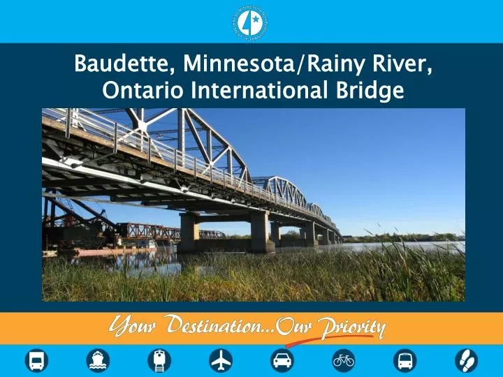
Baudette, Minnesota/Rainy River, Ontario International Bridge. Location. Location. US and Canadian Customs facilities are at each end of the bridge approach Alignment on US side made challenging by US Customs equipment, City park, substation and archeological sites

E N D
Baudette, Minnesota/Rainy River, Ontario International Bridge
Location • US and Canadian Customs facilities are at each end of the bridge approach • Alignment on US side made challenging by US Customs equipment, City park, substation and archeological sites • Alignment on Canadian side expected to be less affected by Customs location, but archeological and other issues may still exist
History • This bridge provides access to Baudette, Minnesota and Rainy River, Ontario, a connection between the United States and Canada as well as a full-service, 24-hour Port of Entry • Originally built in 1959 by the Cities of Baudette, MN and Rainy River, ON • The bridge has a total length of 1,285 feet and accomodates a 2-lane roadway with a width of 24 feet and an open grate steel deck • Operated locally as a toll bridge until 1988, when ownership was taken over by the Minnesota Department of Transportation (MnDOT) and the Ministry of Transportation, Ontario (MTO)
Project Purpose • The current project was initiated to address structural issues and the long-term need to continue providing a safe and reliable river crossing at this location • The bridge is classified as fracture critical (non redundant)
Project Details • Bridge was found ineligible for inclusion on the Ontario Heritage Bridge List • MTO provided a position paper to the MnDOT stating MTO does not consider rehabilitation viable
Project Details • Bridge is eligible for the National Register of Historical Places in the United States • MnDOT is nearly complete with its rehabilitation study • Next steps will be to work through Section 106 of the National Historic Preservation Act and likely Section 4(f) of the Department of Transportation Act
Project Details • In the meantime, concurrent work has begun looking at replacement • Initial discussions were focused on developing project separately • This approach potentially solved some of the bureaucratic concerns, but it created others……
Project Details • Current approach is to have MnDOT lead (with close coordination with MTO) the environmental documentation, preliminary design, structure type study and early stakeholder coordination of the project • Work is underway to develop a cost-sharing agreement • Consultant will be required to either have offices in both the US and Canada, or at least partnering with approved firms on both sides of the border • Handling of detail design and construction will be decided in the future
Project Details • Presidential Permit not required • Congressional Authorized Bridge under International Bridge Act of 1972 • Existing owners of congressional authorized bridges may replace, repair or expand their existing bridges without further State Department approval • Early consultant effort ongoing • Compile agency stakeholder list with contact information • Compile list of permits/approvals needed • Anticipated duration for obtaining permits/approvals • Comparison of design standards/requirements between MnDOT and MTO
Project Details • Potential Agency Stakeholders: • MN SHPO • MN DNR • USACE • FHWA • US Customs • US State Department • US Coast Guard • GSA • Ontario Ministry of the Environment • Department of Fisheries and Oceans • Division of Water Quality • Ontario Ministry of Natural Resources • First Nations • Transport Canada, Navigable Waters • Canadian Border Service Agency
Project Timeline • A detailed critical path schedule has been developed • Schedule shows 300 days of float given a late summer 2013 consultant notice to proceed and letting date of November 2017 • Project needs to be let no later than April 2018 to take advantage of Minnesota bonding dollars • Current schedule only includes MnDOT processes • Need to allow procurement time for detail design consultant