Download
1 / 170
1.7k likes | 1.86k Views
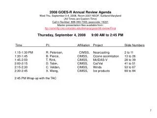
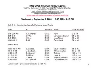
2008 GOES-R Annual Review Agenda Wed-Thu, September 3-4, 2008, Room 2001 NSOF, Suitland Maryland (All Times are Eastern Time) Call in Number: 888-390-7303, passcode: 16221 Master presentation files available from: ftp://rammftp.cira.colostate.edu/demaria/goesr08-review/Final

E N D
2008 GOES-R Annual Review Agenda Wed-Thu, September 3-4, 2008, Room 2001 NSOF, Suitland Maryland (All Times are Eastern Time) Call in Number: 888-390-7303, passcode: 16221 Master presentation files available from: ftp://rammftp.cira.colostate.edu/demaria/goesr08-review/Final Wednesday, September 3, 2008 8:45 AM to 4:15 PM 8:45-9:15 Introduction (Mark DeMaria and Ingrid Guch) Time P.I. Affiliation Project Slide Numbers 9:15-9:30 AM P. Romanov CICS, NDVI 2 to 18 9:30-9:45 D. Vila CICS, Convective System 20 to 36 9:45-10:00 H. Lee CICS, Long Wave 38 to 50 10:00-10:15 Z. Li CICS, Rain+cloud 52 to 66 15 min Break 10:30-10-45 AM L. Grasso, CIRA, Severe weather 68 to 85 10:45-11:00 J. Dostalek, CIRA, Winter weather 87 to 103 11:00-11:15 B. Connell CIRA, Training 105 to 115 11:15-11:30 D. Hillger, CIRA, Hazards 117 to 133 11:30-11:45 J. Knaff, CIRA, Tropical cyclones 135 to 154 11:45-12:00 D. Zupanski CIRA, Data assimilation 156 to 170 Lunch break – presentations resume at 1:00 PM
1. Title Page • Title: Evaluation and improvement of NDVI algorithm for GOES-R • Project Type: Product Improvement Proposal • Status: New • Duration: 3 Years • Leads: Peter Romanov • CICS/University of Maryland • Other Participants: Hui Xu • IMSG
2. Project Summary • Objectives • Evaluate apparent angular anisotropy in NDVI as observed from geostationary satellites • Develop an algorithm for correcting NDVI for angular anisotropy • Develop an improved compositing algorithm for GOES-R NDVI product • Approach • Meteosat SEVIRI will be used as GOES-R prototype. • Anisotropy of NDVI with respect to viewing and illumination geometry will be assessed using SEVIRI data over Europe and Africa • Different daily compositing algorithms will be applied and compared • Kernel-driven models will be used to correct for angular anisotropy • Expected Results and Benefits: • Improved GOES-R ABI NDVI product • Reduced spurious variability in GOES-R NDVI time series • Consistent estimates of NDVI seasonal variation and spatial distribution • Comparability of NDVI derived from polar and geo satellites
3. Motivation/Justification • Supports NOAA Mission Goal(s): Ecosystems, Weather, Climate • Angular anisotropy is inherent to visible and near infrared reflectance observed from satellites, as a result NDVI also depends on viewing and illumination geometry of observations. Angular anisotropy hampers comparison of NDVI observed at different times of the day and at different locations. It causes spurious variability in NDVI time series. • Angular anisotropy should also be accounted for in NDVI daily compositing algorithms. These algorithms use multiple daily observations from geostationary satellites to produce the most cloud-clear NDVI map. • The problem of NDVI angular anisotropy was identified as a high risk area by GOES-R Land Surface Team. Current GOES-R NDVI algorithms does not account for NDVI angular anisotropy
4. Methodology • Use Meteosat SEVIRI as GOES-R prototype • Select several test areas in Europe and Africa characterized by different vegetation cover type • Evaluate angular anisotropy of NDVI for every land surface cover type • Assess diurnal variability of NDVI due to changing illumination conditions • Assess spatial variations of NDVI due to changing viewing geometry. • For every biome identify the range of observation geometries providing NDVI variability within acceptable limits (0.04) • Assess the accuracy of bidirectional correction of NDVI • Correcting visible and near IR reflectances contributing to NDVI • Develop kernel-driven models for direct BRDF correction of NDVI. • Evaluate the effect of BRDF correction • On the seasonal change of NDVI for various biomes • On the derived spatial distribution of NDVI. • Compare NDVI derived from polar orbiting and geostationary satellites
5. Expected Outcomes • Improved algorithm for daily compositing of NDVI data for GOES-R ABI • Assessment of potentials for NDVI angular correction with kernel-driven models. Algorithm for angular correction of NDVI • Results of comparison of NDVI time series derived from polar orbiting and geostationary satellites • Yearly time series for different biomes • Assessment of benefits of frequent observations from geo satellites for monitoring seasonal NDVI change
6. Progress in FY2008 • Polar and geo NDVI has been compared. Benefits of using geostationary satellites for NDVI monitoring have been demonstrated. • Evaluated angular anisotropy of NDVI as observed from geo satellites • Established criteria for max NDVI compositing • Technique to correct geo NDVI maps for satellite zenith angle effect has been developed
MSG weekly MSG daily AVHRR weekly AVHRR weekly (running average) Year 2007 MSG vs AVHRR NDVI Time Series NOAA/AVHRR: GVI dataset, weekly max NDVI compositing MSG/SEVIRI: Daily and weekly max NDVI compositing
NDVI Change Rate • NDVI change rate around the time of max NDVI • Calculated within +/- 2 hours from the time of maximum • Dark green: flat shape • Yellow/red: bowl shape
6.30 10.30 11.30 12 12.30 13.30 17.30 Local Time, hr Time of max NDVI Jul 18-24, 2006 Oct 27 – Nov 2, 2006 Jan 10-16, 2007 Optimal conditions for compositing: Time: 8h to 13h local time Solar elevation: above 200 -250 Time of max NDVI, frequency distribution
80 80 60 60 40 40 Satellite zenith angle AVHRR: Random angle values within 0 to ~60 deg AVHRR NDVI vs MSG NDVI 80 80 60 60 40 40 Satellite zenith angle Satellite zenith angle AVHRR: Random angle AVHRR: Random angle values within 0 to ~60 deg values within 0 to ~60 deg MSG SEVIRI MSG SEVIRI Derived from half Derived from half - - hourly hourly NOAA NOAA - - 18 AVHRR 18 AVHRR images at 4 km resolution images at 4 km resolution (derived from 16 km (derived from 16 km GVIx GVIx ) ) Weekly composites for July 16-22, 2006
MSG NDVI Angle Correction Model Dash lines: Observed Solid lines: Model Proposed geo NDVI satellite zenith angle correction model: NDVICOR = C0 + C1 NDVIMSG + C2 cos(Ɵsat) + C3 NDVIMSG cos(Ɵsat)
7. FY09-10 Milestones • FY09 • Develop and test bidirectional correction algorithm for NDVI • Incorporate NDVI angular correction in the MSG processing system and test in a quasi-operational mode • FY10 • Improved algorithm for NDVI angular correction is incorporated in the MSG processing system • Algorithms are prepared operational implementation
8. Funding Profile (K) • Summary of leveraged funding • none
9. Expected Purchase Items • FY09 • (30K): STAR CICS Grant for 1 person for 2.5 months from Oct 2008 to Oct 2009 - Personal support for Peter Romanov: 30K • FY10 • (31K): STAR CICS Grant for 1 person for 2.5 months from Oct 2009 to Oct 2010 - Personal support for Peter Romanov: 31K
1. FY08 GOES-R3 Project Proposal Title Page • Title: Mesoscale Convective System Climatology using Geostationary Infrared Imagery • Project Type: 2 • Status: continuation of task • Duration: 3 years (1 year) • Leads: • Daniel Vila – CICS/ESSIC/UMD • Ralph Ferraro – NESDIS/STAR/CORP • Other Participants: • Bob Kuligowski – NESDIS/STAR/SMCD
2. Project Summary • Use the cloud tracking / nowcasting methodology selected by the GOES-R Algorithm Working Group (AWG) for application to the ABI to track mesoscale convective systems (MCS’s) in SEVIRI data through their entire life cycle. • Analyze the MCS life cycle events to find a priori indicators that are useful for forecasting changes in MCS intensity and / or that are related to any biases in the AWG-selected quantitative precipitation estimation (QPE) algorithm. • Incorporate any useful findings into the operational GOES-R rainfall nowcasting and / or QPE code.
3. Motivation/Justification • Supports the following NOAA Mission Goal(s): • Weather and Water • Climate • MCS’s are responsible for most of the warm-season rainfall over many regions around the world, and their frequency is the principal factor determining inter-annual climate variability. They also can produce extreme weather such as strong winds, hail, and flash floods. • Previous study of longitudinal MCS climatology over North America has been limited (Augustine et al. 1989; Machado et al. 1998) • Information about the climatology of the MCS life cycle might be useful for improving the nowcasting of MCS evolution. • The GOES-R AWG identified rainfall nowcasting as a high-risk area that need further research. • Expected users: National Weather Service (NWS) and NESDIS Satellite Analysis Branch (SAB) among others.
4. Methodology • Use the cloud tracking methodology selected by the GOES-R Algorithm Working Group (AWG) for application to the ABI to track convective events in SEVIRI data through their entire life cycle. • The SEVIRI database from the AWG Proxy Data Team covering the first 9 days of January, April, July, October 2005 will be used. • Additional data will include corresponding MW rain rates from SSM/I, AMSU, AMSR and TMI, and ground validation data from the AWG Proxy Data Team. • Analyze the MCS life cycle events to find a priori indicators that are useful for forecasting changes in MCS intensity. • Determine if there are any relationships between the MCS life cycle phase and any biases in the QPE from the operational GOES-R algorithm. • Perform appropriate modifications to the AWG-selected nowcasting and / or rain rate retrieval algorithms and validate against the original algorithms using the above dataset. • Work with the AWG to incorporate any useful modifications into the operational algorithm code.
5. Summary of Previous Results • No previous work on MCS climatology has been funded by GOES-RRR, but other relevant work has been performed in different regions of the world. • Figure 1 shows how tracking information can reveal the physical processes involved in convective activity for a given region for use in conceptual models. In this case, the mean diurnal cycle of initiation, maximum extent and dissipation stage of MCS’s for low level jet events (SALLJ, dark gray) and non-low level jet events (NOSALLJ, light gray) in a tropical environment over South America were examined (Salio et al. 2007). Figure 1: Frequency distributions in percent of MCSs for SALLJ (dark gray) and NOSALLJ (light gray) samples of (left) initiation, (middle) maximum extent, and (right) dissipation time in UTC in a tropical environment over South America (from Salio et al, 2007).
6. Expected Outcomes • If useful relationships are found relating MCS life cycle stage to intensity or other changes, these relationships will be incorporated into a test version of the GOES-R nowcasting code, and, if positive impact is demonstrated, incorporated into the operational version of the code. • If useful relationships are found relating MCS life cycle stage to biases in the GOES-R rain rates, then these also will be tested and incorporated into the operational GOES-R rain rate code if results warrant. • In any event, advances will be made in the knowledge of favorable environmental conditions for the development of large MCS’s.
7. Major Milestones • FY08 • Implement a test version of the operational AWG-selected GOES-R nowcasting code. • Use the code to identify and track MCS’s in the AWG Proxy Data Team SEVIRI database. • Develop conceptual models relating MCS life cycle stage and changes in MCS intensity and other characteristics. • FY09 • Incorporate the conceptual models into the test version of the GOES-R nowcasting code. • Test the impact of the nowcasting code modifications and, if results warrant, work with the AWG to incorporate the modifications into the operational nowcasting code. • Develop conceptual models relating MCS life cycle stage to biases in the operational GOES-R QPE. • FY10 • Incorporate the conceptual models into a test version of the GOES-R QPE code. • Test the impact of the QPE code modifications and, if results warrant, work with the AWG to incorporate the modifications into the operational nowcasting code.
Summary of the Current Research ActivitiesTechnique Description The ForTraCC technique (Forecasting and Tracking the evolution of Cloud Clusters) is an algorithm that allows to track the MCS radiative and morphological properties and forecast the evolution of these physical properties (based on cloud top brightness temperature) up to 180 minutes, using infrared satellite imagery (10.8 µm). The main features of this algorithm are the following ones: • Cloud cluster detection methodology based on a size and temperature threshold; • Statistical module to perform morphological and radiative parameters of each MCS; • Tracking technique based on MCS overlapping areas between successive images; and • Forecast module based on statistical information about MCS behavior and the life cycle evolution of each MCS.
Summary of the Current Research ActivitiesValidation Strategies • ForTrACC validation has been followed the guidelines presented in the GOES-R AWG Hydrology Algorithm Intercomparison Test Plan. • Only 10.8 micron infrared band has been validated. • Nowcasts of SEVIRI data will be created at initialization times of every 3 hours beginning at 0000 UTC and cover every 15 minutes out to a lead time of 3 hours. • Four weeks along 2005 and two temperature thresholds (240 K and 210 K) were selected to perform the intercomparison: • 6-9 January 2005, • 6-9 April 2005, • 6-9 July 2005 and • 6-9 October 2005.
Summary of the Current Research ActivitiesValidation Strategies
Summary of the Current Research ActivitiesValidation Strategies
Summary of the Current Research ActivitiesValidation Strategies
8. Funding Profile (K) • Summary of leveraged funding • Leverages QPE and nowcasting development work under the auspices of the GOES-R AWG.
9. Expected Purchase Items • FY08 • (75K): 1 STAR CICS Grant for 1 half-time person (Daniel Vila) for 12 months from Jan 08 through Dec 08 • FY09 • (77K): 1 STAR CICS Grant for 1 half-time person (Daniel Vila) for 12 months from Jan 09 through Dec 09 • FY10 • (80K): 1 STAR CICS Grant for 1 half-time person (Daniel Vila) for 12 months from Jan 10 through Dec 10
Summary of the Current Research ActivitiesTechnique Description
Summary of the Current Research ActivitiesValidation Strategies
1. FY08 GOES-R3 Project Proposal Title Page • Title: Development of Longwave Radiation Budget Products for GOES-R ABI and HES Instruments • Project Type: Development • Status: Renewal • Duration: 3 years • Leads: Hai-Tien Lee (CICS/ESSIC-NOAA) Istvan Laszlo (STAR)
2. Project Summary • Objective: Develop and implement retrieval algorithms of longwave radiation budget parameters for GOES-R ABI and HES. (HES development was suspended since FY2007.) • Products: • OLR – TOA outgoing longwave radiation • DLW – Surface downward longwave radiation • ULW – Surface upward longwave radiation • LCR – Atmospheric layer cooling rate • Method: OLR, DLW and LCR uses HIRS heritage regression model methodology. ULW uses physical derivation. • Adapt and improve upon the heritage POES techniques for the new GOES-R instruments and to resolve problems pertaining to the fixed geostationary satellite observing geometry. • Develop synergy with POES observations to alleviate GOES-R limitations, e.g., lack of sounder, and cloudy condition retrievals. • Work is done at CICS/ESSIC with ORA contribution.
3. Motivation/Justification • Supports NOAA Mission Goals: • Climate • Weather and Water • GOES R3 Plan ver.9, Dec 2006: • Provide accurate description of earth radiation’s diurnal variation at both TOA and surface that is important • in understanding the physical processes of ERB diurnal variations; • to complement POES ERB observations for time integral; • for NWF/GCM diagnosis, particularly for convections. • Deliver GOES-R MRD-2B ERB parameters – OLR, DLW, and ULW. • AWG Radiation Budget AT identified degradation of surface LW flux estimate due to unavailability of HES measurements, and suggested exploring the use of EOS soundings. • TAC recommendation: Demonstrate impact of loosing HES on LW flux, and supported exploration of synergy between ABI and EOS sounding for LW.
4. Methodology • OLR, DLW and LCR – HIRS Multi-spectral regression techniques; ULW – Physical derivation. • Radiative transfer model to simulate radiative flux and satellite radiance observations given a large set of representative atmospheric profiles • Linear/non-linear regression analysis to determine regression coefficients as functions of viewing zenith angles (azimuth symmetry assumed) • Develop methods to incorporate ancillary information and improve accuracy – scene type, cloud properties (cloud base height and temperature), LW broadband surface emissivity, skin temperature, atmospheric temperature and humidity profiles, POES observations/products. • Develop Product Validation and Monitoring plan and QC/QA procedures.
5. Summary of Previous Results • This was a new project, so no results from previous R3 support are available
6. Expected Outcomes • ABI LW radiation budget algorithms (OLR, DLW and ULW) that qualify the threshold requirements. • Improved OLR algorithm that reduces biases over deserts • Investigate source of errors in DLW and ULW retrieval for diurnal dependent biases • Devise methods to estimate broadband emissivity and reflectivity to improve ULW accuracy. • Using POES/EOS observations/products to perform cloudy condition retrievals for DLW and ULW. • Product Validation and Monitoring plan. • QC/QA procedures. • Detailed results of tests and evaluation of quality of LW retrievals. • Publication, ATBD, software and technical documentations.
Illustration of Expected Outcomes Fort Peck ULW Goodwin Creek DLW
7. Major Milestones • FY08 • ABI OLR, DLW and ULW algorithms in Collaborative Environment are implemented. (FORTRAN coding in process) • Operationally generated proxy OLR product are evaluated and validated. (Pending on proxy data availability) • DLW and ULW algorithms are ready. (Preliminary evaluation completed) • Impact of EOS sounding data is analyzed. (Postponed) • ATBD is ready. (Draft for Ver. 1 algorithms completed) • FY09 • Evaluate and validate operationally generated proxy LW ERB product (Continue) • Investigate diurnal dependent errors in DLW and ULW (new) • Investigate OLR bias over deserts (new) • Develop broadband emissivity/reflectivity estimation method (new) • Explore DLW/ULW cloudy sky retrieval methods using POES/EOS observations and products(new) • Initiate development of LCR algorithm. • FY10 • LCR validation/evaluation databases are collected. (pushed) • LCR algorithms are validated, and accuracy is assessed. (pushed) • Reports documenting validation of LCR algorithm are ready for delivery. (pushed) • Second phase of assessments and algorithm improvement are started. • Day one algorithm system is ready. • Final design review for operational day one system for longwave radiation budget products. • ATBD is ready for delivery.
7a. FY08 Accomplishments • The revised SEVIRI OLR algorithm eliminates overall limb-dependent biases and the regional biases in subtropical oceans. But relatively large biases remained over deserts. • CICS and LPLA DLW algorithms were evaluated over land under clear sky condition with GOES Sounder retrievals. • Physical derivation of ULW was evaluated with blackbody and grey body assumptions using GOES Imager and MODIS retrievals over land under clear sky condition. • Diurnal dependent biases seemed to present in DLW and ULW retrievals. Error sources yet to be identified. • Broadband emissivity and reflectivity development underway. • ABI Version 1 OLR, DLW and DLW ATBD Draft completed.
-6 -3 3 6 Wm-2 OLE Validation 7b. FY08 Accomplishments Model C eliminated limb-dependent biases and regional biases over subtropical oceans. But biases over deserts remained. N=99,123 Mean diff= -1.5 Std diff=3.7 RMS diff=4.0 N=99,123 Mean diff= -1.2 Std diff=2.9 RMS diff=3.1 SEVIRI-CERES OLR Comparison of two SEVIRI OLR models SEVIRI OLR vs CERES OLR for June 21-27 and Dec. 11-17, 2004 over Meteosat8 full disk domain collocated with CERES SSF data at view zenith angle matched homogeneous scenes, both day & night.
7c. FY08 Accomplishments ULW Validation DLW Validation N=1210 Mean Diff= -8.4 STD Diff=13.8 RMS Diff=16.2
8. Funding Profile (K) • Summary of leveraged funding • LW Earth Radiation Budget study is supported jointly by the GOES-R Risk Reduction and AWG programs. FY2009 funding contribution from the two programs are to be determined. • Note that the FY08 AWG funding Included 25K support for a senior consultant. This was not included in the original budget projection.
9. Expected Purchase Items • FY07 • (85K): STAR CICS Grant for 1 people (Hai-Tien Lee @ 60%) from Jul 06 to Jun 07 • Research Material 1 K • Travel 2 K (GEWEX RFA meeting, AWG Annual Meeting) • Personnel 55 K • FY08 • (80K): STAR CICS Grant for 1 people (Hai-Tien Lee @ 50%) from Jul 07 to Jun 08 • Publication 3 K • Research Material 2 K • Travel 2 K (GOES-R Users Conference, AWG Annual Meeting) • Hardware 3 K • Personnel 45 K • FY09 • (80K): STAR CICS Grant for 1 people 1 people (Hai-Tien Lee @ 50%) from Jul 08 to Jun 09 • Publication 3 K • Research Material 2 K • Travel 2 K (Sat Met Conference, AWG Annual Meeting) • Personnel 47 K • FY10 • (162K): STAR CICS Grant for 1 people at (Hai-Tien Lee @ 50%) from Jul 09 to Jun 10 • Publication 3 K • Research Material 2 K • Travel 2 K (GOES-R Users Conference, AWG Annual Meeting) • Personnel 50 K Note: Overhead is Included in the total. Itemized expenses are direct cost only.