Understanding Oceanography: The Major Oceans, Salinity, and Ocean Floor Features
This guide delves into the fascinating world of oceanography, highlighting the three major oceans: the Atlantic, Pacific, and Indian. It explores key concepts such as ocean salinity, which contains approximately 35 parts per thousand of dissolved salts, and the classification of oceanic zones, including the surface, thermocline, and deep zones. Additionally, it covers ocean floor topography, detailing features such as submarine canyons, continental shelves, slopes, abyssal plains, trenches, and coral reefs, illustrating the dynamic relationship between land and ocean.

Understanding Oceanography: The Major Oceans, Salinity, and Ocean Floor Features
E N D
Presentation Transcript
THEMAJOROCEANS ATLANTIC, PACIFIC, AND INDIAN
SALINITY THE AMOUNT OF DISSOLVED SALTS IN THE OCEAN WATER (35 PARTS /1000)
96% THE % OF THE OCEAN THAT IS PURE WATER
SURFACE ZONE WHERE THE WATER IS MIXED BY WAVES & CURRENTS ( AT LEAST 100 M DEEP)
THERMOCLINE ZONE OF RAPID TEMPERATURE CHANGE (NO SPECIFIC DEPTH)
DEEP ZONE ZONE FROM THE BOTTOM OF THE THERMOCLINE ON DOWN (NOT FOUND IN ARCTIC OR ANTARTIC OCEANS) WATER TEMPERATURE JUST ABOVE FREEZING
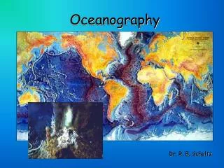
TOPOGRAPHY DESCRIPTION AND SHAPE OF THE OCEAN FLOOR
SUBMARINE CANYONS UNDERWATER CANYONS
SHORELINE BOUNDARY WHERE LAND AND OCEAN MEET
CONTINENTAL SHELF RELATIVELY FLAT PART OF THE CONTINENT MARGIN COVERED BY SHALLOW OCEAN WATER
CONTINENTAL SLOPE THE EDGE OF THE CONTINENTAL SHELF THAT DROPS SHARPLY
CONTINENTAL RISE SEPARATES THE CONTINENTAL SLOPE FROM THE OCEAN FLOOR
CONTINENTAL MARGIN WHERE THE UNDERWATER EDGE OF THE CONTINENT MEETS THE OCEAN FLOOR
ABYSSAL PLAINS LARGE, FLAT AREAS ON THE OCEAN FLOOR
SEAMOUNTS UNDERWATER MOUNTAINS (IF ABOVE THE WATER THEY ARE CALLED ISLANDS)
GUYOTS FLAT TOP SEAMOUNTS
TRENCHES LONG, NARROW CRACKS IN THE OCEAN FLOOR
MID-OCEAN RIDGES UNDERWATER MOUNTAIN RANGES FORMED BY VOLCANIC ACTION
CORAL REEFS LIMESTONE STRUCTURES SURROUNDING VOLCANIC ISLANDS
FRINGING REEF REEF TOUCHES SHORELINE OF THE VOLCANIC ISLANDS
BARRIER REEF REEF SEPARATED FROM THE ISLAND BY A SHALLOW LAGOON